Huber, Oregon

Last updated
Huber
Aerial view Tualatin Hills Nature Park 1998.jpg
Aerial photograph of the Tualatin Hills Nature Park in 1998,
Huber is in the foreground.
Hillsboro Beaverton Oregon - OpenStreetMap.png
Red pog.svg
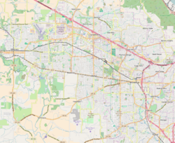
Huber
Location within Washington County, OR [1]
Coordinates: 45°29′31″N122°51′4″W / 45.49194°N 122.85111°W / 45.49194; -122.85111 Coordinates: 45°29′31″N122°51′4″W / 45.49194°N 122.85111°W / 45.49194; -122.85111
Country United States
State Oregon
County Washington
Elevation
197 ft (60 m)
Time zone UTC-8 (Pacific (PST))
  Summer (DST) UTC-7 (PDT)
ZIP codes
97007
GNIS feature ID1166664 [2]

Huber is an unincorporated community in Washington County, Oregon, United States, now mostly located within Aloha near the Tualatin Hills Nature Park.

History

Huber was established in 1910. It is named for Jacob Huber, an early resident of the area. The Huber post office opened in 1916 and was closed on December 31, 1953. [3]

Related Research Articles

Washington County, Oregon County in Oregon, United States

Washington County is one of 36 counties in the U.S. state of Oregon and part of the Portland metropolitan area. The 2020 census recorded the population as 600,372, making it the second most populous county in the state and most populous "Washington County" in the United States. Hillsboro is the county seat and largest city, while other major cities include Beaverton, Tigard, Cornelius, Banks, Gaston, Sherwood, North Plains, and Forest Grove, the county's oldest city. Originally named Twality when created in 1843, the Oregon Territorial Legislature renamed it for the nation's first president in 1849 and included the entire northwest corner of Oregon before new counties were created in 1854. The Tualatin River and its drainage basin lie almost entirely within the county, which shares its boundaries with the Tualatin Valley. It is bordered on the west and north by the Northern Oregon Coast Range, on the south by the Chehalem Mountains, and on the north and east by the Tualatin Mountains, or West Hills.

La Grande, Oregon City in Oregon, United States

La Grande is a city in Union County, Oregon, United States. Originally named "Brownsville," it was forced to change its name because that name was being used for a city in Linn County. Located in the Grande Ronde Valley, the city's name comes from an early French settler, Charles Dause, who often used the phrase "La Grande" to describe the area's beauty. The population was 13,082 at the 2010 census. It is the county seat of Union County. La Grande lies east of the Blue Mountains and southeast of Pendleton.

Shaniko, Oregon City in Oregon, United States

Shaniko is a city located in Wasco County, Oregon, United States, on U.S. Route 97 and about 8 miles (13 km) north of Antelope. The population was 36 at the 2010 census.

Hillsboro, Oregon City in Oregon, United States

Hillsboro is the fifth-largest city in the U.S. state of Oregon and is the county seat of Washington County. Situated in the Tualatin Valley on the west side of the Portland metropolitan area, the city hosts many high-technology companies, such as Intel, locally known as the Silicon Forest. At the 2020 census, the city's population was 106,447.

<i>Oregon Geographic Names</i> Work by Lewis A. McArthur

Oregon Geographic Names is a compilation of the origin and meaning of place names in the U.S. state of Oregon, published by the Oregon Historical Society. The book was originally published in 1928. It was compiled and edited by Lewis A. McArthur. As of 2011, the book is in its seventh edition, which was compiled and edited by Lewis L. McArthur.

Tualatin Valley Farming and suburban region southwest of Portland, Oregon

The Tualatin Valley is a farming and suburban region southwest of Portland, Oregon in the United States. The valley is formed by the meandering Tualatin River, a tributary of the Willamette River at the northwest corner of the Willamette Valley, east of the Northern Oregon Coast Range. Most of the valley is located within Washington County, separated from Portland by the Tualatin Mountains. Communities in the Tualatin Valley include Banks, Forest Grove, Cornelius, Hillsboro, Aloha, Beaverton, Sherwood, Tigard, and Tualatin.

Willamette Stone Small stone obelisk

The Willamette Stone was a small stone obelisk originally installed by the Department of Interior in 1885 in the western hills of Portland, Oregon in the United States to mark the intersection and origin of the Willamette meridian and Willamette baseline. It replaced a cedar stake placed by the Surveyor General of the Oregon Territory in 1851; this stake defined the grid system of sections and townships from which all real property in the states of Oregon and Washington has been measured following the Donation Land Claim Act of 1850. The Willamette meridian runs north–south, and the Willamette baseline runs east–west through the marker. The easternmost northeast corner of Washington County is sited on the marker.

Oysterville, Washington Unincorporated community in Washington, United States

Oysterville is an unincorporated community located along Willapa Bay on the Long Beach Peninsula in Pacific County, Washington, United States. It is approximately 5 miles (8.0 km) from the city of Ocean Park, and 15 miles (24 km) from Long Beach. Founded in 1841 as an oyster fishing village, the community is registered on the National Register of Historic Places as the Oysterville Historic District. It currently has a population of about 20 residents.

Cheshire, Oregon Unincorporated community in the State of Oregon, United States

Cheshire is an unincorporated community in Lane County, Oregon, United States. It is located near the Long Tom River and is southwest of Junction City on Oregon Route 36.

Vida, Oregon Former unincorporated community in Oregon, United States

Vida is an unincorporated community in Lane County, Oregon, United States. It is located on Oregon Route 126 and the McKenzie River.

Tanasbourne, Oregon Neighborhood in Washington County, Oregon, United States

Tanasbourne, Oregon, is a neighborhood in Washington County, Oregon, where NW 185th Avenue and the Sunset Highway intersect. It is located within the Portland metropolitan area. The area sits between Beaverton and Hillsboro, and is generally considered to be south of U.S. 26, north of Walker Road, west of 158th, and east of Cornelius Pass Road. Adjacent to Aloha and part of the West Metro region, Tanasbourne has many shopping areas and is the former home of the defunct Tanasbourne Mall.

Austin is an unincorporated community, considered a ghost town, in Grant County, Oregon, United States. It is located north of Oregon Route 7, near the Middle Fork John Day River in the Malheur National Forest.

Like many other U.S. states, the politics of Oregon largely concerns regional issues. Oregon leans Democratic as a state, with both U.S. senators from the Democratic party, as well as four out of Oregon's five U.S. Representatives. The Democratic candidate for president has won in Oregon in every election since 1988. Both houses of Oregon's legislative assembly have been under Democratic control since the 2012 elections.

Bald Peak State Scenic Viewpoint State park in Oregon, USA

Bald Peak State Scenic Viewpoint is a state park located atop Bald Peak located in Yamhill County, in the United States. The day use only park offers picnic tables and a hiking trail for views of the Willamette Valley and the Cascade Range. The state of Oregon acquired the 26 acres (11 ha) in 1931 after Yamhill and Washington counties requested a park from the state.

Gales Creek, Oregon Unincorporated community in the State of Oregon, United States

Gales Creek is an unincorporated community in Washington County, Oregon, United States on Oregon Route 8 northwest of Forest Grove in the foothills of the Oregon Coast Range.

Mountaindale, Oregon Unincorporated community in the State of Oregon, United States

Mountaindale is an unincorporated community in Washington County, Oregon, United States, about four miles northwest of North Plains. Settled in the 1850s, the small community was the longtime home of the Mountaindale Store. The area is part of Washington County Fire District 2.

Greenville, Washington County, Oregon

Greenville is an unincorporated historic community in Washington County, Oregon, United States. It is located approximately two miles south of Banks on Oregon Route 47.

Bonita, Oregon Unincorporated community in the State of Oregon, United States

Bonita is a former unincorporated community in Washington County, Oregon, United States, now located within the boundaries of the city of Tigard.

Bacona is an unincorporated community in northern Washington County, Oregon, United States.

References

  1. "Huber (in Washington County, OR) Populated Place Profile". HomeTownLocator. Retrieved October 11, 2016.
  2. U.S. Geological Survey Geographic Names Information System: Huber, Oregon
  3. McArthur, Lewis L. (1992). Oregon Geographic Names (sixth edition). Oregon Historical Society Press. p. 428. ISBN   0-87595-236-4.