Bull Mountain, Oregon

Last updated

Bull Mountain, Oregon
Bull Mountain Oregon.JPG
Top of Bull Mountain
USA Oregon location map.svg
Red pog.svg
Bull Mountain, Oregon
Location within the state of Oregon
Usa edcp location map.svg
Red pog.svg
Bull Mountain, Oregon
Bull Mountain, Oregon (the United States)
Coordinates: 45°24′45″N122°49′55″W / 45.41250°N 122.83194°W / 45.41250; -122.83194
Country United States
State Oregon
County Washington
Area
[1]
  Total1.98 sq mi (5.14 km2)
  Land1.98 sq mi (5.14 km2)
  Water0.00 sq mi (0.00 km2)
Elevation
[2]
561 ft (171 m)
Population
 (2020) [3]
  Total9,992
  Density5,036.29/sq mi (1,944.27/km2)
Time zone UTC-8 (Pacific (PST))
  Summer (DST) UTC-7 (PDT)
ZIP codes
97223, 97224
Area code 503
FIPS code 41-09535
GNIS feature ID2584409 [2]

Bull Mountain is an unincorporated community and census-designated place in Washington County, Oregon, United States. Bull Mountain is located mostly on a hill for which the community is named. It is bordered on the east by Tigard, on the south by King City, and Beaverton lies to the north. The north-eastern part of the Bull Mountain hill is now within the Tigard city limits, as the city has steadily annexed portions of the unincorporated region on its boundary. In 2010, the community became a census-designated place with a population of 9,133. [4] Fire protection and EMS services are provided through Tualatin Valley Fire and Rescue. [5]

Contents

Demographics

As of the census of 2020, there were 9,992 people in 3,259 households residing in the city. The population density was 5,016.1 inhabitants per square mile (1,936.7/km2). The racial makeup of the city was 81.4% White, 4.0% African American, 0.8% Native American, 8.4% Asian, 0.9% Pacific Islander, and 3.6% from two or more races. Hispanic or Latino of any race were 5.57% of the population.

There were 3,259 households. The average household size was 2.93.

25.2% of residents were under the age of 18, and 11.8% were 65 years of age or older. The gender makeup of the city was 49% male and 51% female. [6]

Historical population
CensusPop.Note
2020 9,992
U.S. Decennial Census [7] [3]

Annexation and incorporation controversy

Bull Mountain Road Bull Mountain Road in Tigard Oregon.JPG
Bull Mountain Road

The Bull Mountain area has been considered candidate for annexation by the City of Tigard, which includes Bull Mountain in its ultimate planned boundary. The debate over Bull Mountain's future has been rather acrimonious.

In 2004, Tigard proposed to annex the entire area under Oregon Revised Statutes Or. Rev. Stat. § 195.205 (2005) [8] (Urban Service Provider Annexation method) instead of Or. Rev. Stat. § 222.125 (2005) method. [9] At the time, Or. Rev. Stat. § 195.205 was ambiguous regarding the method of counting votes, and Tigard had planned to use a single combined voting method where the unincorporated votes would be counted with the votes of the city voters, and thus the unincorporated voters would be heavily outnumbered. This variation of gerrymandering outraged [10] [11] many of the residents of the unincorporated area, and triggered a campaign against the annexation. A group called "Friends of Bull Mountain" (FOBM) was then formed. The group retained legal counsel Larry Derr and challenged the combined voting method under the provisions of Or. Rev. Stat. § 268 (2005) requiring separate double majority vote counting for annexations within the Portland Metro Urban Growth Boundary. [12]

In the face of this legal challenge Tigard relented and allowed the double majority vote counting method. [13] As a result, the annexation measure [34-98] failed, a majority of city voters (64.71%) [14] favored the annexation, but 88.62% of unincorporated voters rejected the annexation. [14]

As is common in such annexation disputes, a key issue was taxes; many Bull Mountain residents thought that annexation with Tigard would increase their property taxes without a significant increase in public services, and that Tigard was only interested in annexation to expand its tax base. They also felt the ORS-195 combined voting method was "taxation without representation". Some residents of Tigard have complained in response that Bull Mountain residents use Tigard city parks and other services without paying for them.

However, Washington County has been actively encouraging suburban parts of the county to join cities, in order to limit the need for county-provided urban-level services. After the defeat of the referendum, Tigard has been examining small annexations on a case-by-case basis.

Many residents advocated incorporation in order to allow Bull Mountain residents to control their own destiny (and avoid further annexation by Tigard), in spring of 2006 a petition for a ballot measure was filed.

The Washington County Board of Commissioners voted in August 2006 to allow the incorporation ballot initiative to proceed. A feasibility study was conducted by ECONorthwest and it was determined that Bull Mountain has a sufficient tax base to fund city government and services for its residents. The City of Tigard protested the city boundaries, noting that Tigard-owned properties were included in the proposed City of Bull Mountain, and asked that Washington County adjust the boundaries. That request was denied. Tigard also filed a request to annex 61.5 acres (249,000 m2) which are part of the proposed Bull Mountain boundaries. Many in Bull Mountain complained that Tigard's annexation attempt is little more than an 11th-hour attempt to acquire a large segment of land without due respect for the incorporation process and proposed incorporation boundary. The effort was challenged legally in the Washington County courts. This legal challenge was rejected by the state Land Use Board of Appeals: "the city had not unlawfully obtained consent to the annexation," and the petition for appeal was dismissed by the Oregon Court of Appeals. [15]

The referendum on the incorporation question was on the November 2006 ballot and failed by a vote of 1,734 to 1,887. [16]

Friends of Bull Mountain

The Friends of Bull Mountain (FOBM) is a grassroots community organization in the U.S. state of Oregon acting as local advocates for meaningful citizen involvement and responsible land use planning in keeping with the vision of the Bull Mountain Community Plan. [17] The FOBM group played a key role [10] [11] in defeating the attempt by city of Tigard to annex Bull Mountain.

After the 2004 annexation defeat, FOBM worked closely with Oregon House Representative Jerry Krummel who successfully introduced legislation based on ideas and testimony provided by FOBM. [18] Notable changes in the 2005 legislature included House Bill 2484 which codified double-majority vote for all "Service Provider" annexations under ORS-195. Also, HB-2477 eliminated the three-mile (5 km) veto which allowed cities to prevent incorporation of a new city within three miles (5 km). The enactment of HB-2477 allowed the Bull Mountain community to attempt incorporation.

Related Research Articles

<span class="mw-page-title-main">Beaverton, Oregon</span> City in Oregon, United States

Beaverton is a city in Washington County, in the U.S. state of Oregon with a small portion bordering Portland in the Tualatin Valley. The city is among the main cities that make up the Portland metropolitan area. Its population was 97,494 at the 2020 census, making it the 2nd most populous city in the county and the 7th most populous city in Oregon. Beaverton is an economic center for Washington County along with neighboring Hillsboro. It is home to the world headquarters of Nike, Inc., although it sits outside of city limits on unincorporated county land.

<span class="mw-page-title-main">Tigard, Oregon</span> City in Oregon, United States

Tigard is a city in Washington County, Oregon, United States. The population was 54,539 at the 2020 census, making it the 12th most populous city in Oregon. Incorporated in 1961, the city is located south of Beaverton and north of Tualatin, and is part of the Portland metropolitan area. Interstate 5 and Oregon Route 217 are the main freeways in the city, with Oregon Route 99W and Oregon Route 210 serving as other major highways. Public transit service is provided by TriMet, via several bus routes and the WES Commuter Rail line.

<span class="mw-page-title-main">Washington County, Oregon</span> County in Oregon, United States

Washington County is one of 36 counties in the U.S. state of Oregon and part of the Portland metropolitan area. The 2020 census recorded the population as 600,372, making it the second most populous county in the state and most populous "Washington County" in the United States. Hillsboro is the county seat and largest city, while other major cities include Beaverton, Tigard, Cornelius, Banks, Gaston, Sherwood, North Plains, and Forest Grove, the county's oldest city. Originally named Twality when created in 1843, the Oregon Territorial Legislature renamed it for the nation's first president in 1849 and included the entire northwest corner of Oregon before new counties were created in 1854. The Tualatin River and its drainage basin lie almost entirely within the county, which shares its boundaries with the Tualatin Valley. It is bordered on the west and north by the Northern Oregon Coast Range, on the south by the Chehalem Mountains, and on the north and east by the Tualatin Mountains, or West Hills.

<span class="mw-page-title-main">Durham, Oregon</span> City in Oregon, United States

Durham is a city in Washington County, Oregon, United States. Incorporated in 1966, the city is surrounded by Tigard and Tualatin and is adjacent to the Bridgeport Village shopping complex. The population was 1,351 at the 2010 census.

<span class="mw-page-title-main">Millcreek, Utah</span> City in Utah, United States

Millcreek is a city in Salt Lake County, Utah, United States, and is part of the Salt Lake City Metropolitan Statistical Area. The population as of the 2020 Census was 63,380. Prior to its incorporation on December 28, 2016, Millcreek was a census-designated place (CDP) and township.

<span class="mw-page-title-main">Burien, Washington</span> City in Washington, United States

Burien is a suburban city in King County, Washington, United States, located south of Seattle on Puget Sound. As of the 2020 census, making it the 25th most populous city in Washington, Burien's population was 52,066, which is a 56.3% increase since incorporation in 1993. An annexation in 2010 increased the city's population significantly.

<span class="mw-page-title-main">Fairwood, King County, Washington</span> Census-designated place in Washington, United States

Fairwood is an unincorporated community and census-designated place (CDP) in King County, Washington, United States. As of the 2010 census the population was 19,102.

<span class="mw-page-title-main">Eastgate, Bellevue</span> Neighborhood in King, Washington, United States

Eastgate is a neighborhood of Bellevue, Washington, United States. The population was 4,958 at the 2010 census. It was annexed by Bellevue in 2012.

<span class="mw-page-title-main">Tualatin, Oregon</span> City in Oregon, United States

Tualatin is a city located primarily in Washington County in the U.S. state of Oregon. A small portion of the city is also located in neighboring Clackamas County. It is a southwestern suburb in the Portland Metropolitan Area that is located south of Tigard. The population was 27,942 at the 2020 census.

<span class="mw-page-title-main">Tualatin River</span> River in Oregon, United States

The Tualatin River is a tributary of the Willamette River in Oregon in the United States. The river is about 83 miles (134 km) long, and it drains a fertile farming region called the Tualatin Valley southwest and west of Portland at the northwest corner of the Willamette Valley. There are approximately 500,000 people residing on 15 percent of the land in the river's watershed.

<span class="mw-page-title-main">Portland metropolitan area, Oregon</span> Metropolitan statistical area in the United States

The Portland metropolitan area is a metro area with its core in the U.S. states of Oregon and Washington. It has 5 principal cities the largest being Portland, Oregon. The U.S. Office of Management and Budget (OMB) identifies it as the Portland–Vancouver–Hillsboro, OR–WA Metropolitan Statistical Area, a metropolitan statistical area used by the United States Census Bureau (USCB) and other entities. The OMB defines the area as comprising Clackamas, Columbia, Multnomah, Washington, and Yamhill Counties in Oregon, and Clark and Skamania Counties in Washington. The area had a population of 2,512,859 at the 2020 census, an increase of over 12% since 2010.

<span class="mw-page-title-main">Damascus, Oregon</span> Unincorporated community in the state of Oregon, United States

Damascus is a census-designated place and former city in Clackamas County, Oregon, United States. Established in 1867, it was incorporated in 2004 in an effort to enable local land use decision-making control by the community. Its residents voted to disincorporate in 2016, and, after a legal challenge, its disincorporation was completed in 2020. Damascus is located east of Happy Valley and Interstate 205 and west of Boring. The population was 11,050 residents as of the 2020 census.

<span class="mw-page-title-main">Tigard-Tualatin School District</span> School district in Oregon, USA

The Tigard-Tualatin School District (23J) is a school district serving part of the suburban Portland metropolitan area in Oregon including all or portions of the cities of Tigard, Tualatin, Durham, and King City, as well as most of the unincorporated communities of Metzger and Bull Mountain.

<span class="mw-page-title-main">Government Camp, Oregon</span> Census-designated place in Oregon, United States

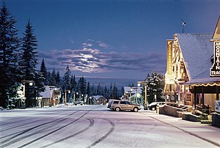
Government Camp is an unincorporated community and census-designated place located in Clackamas County, Oregon, United States, on the base of Mount Hood and north of Tom Dick and Harry Mountain. It is the only town within 5 miles (8 km) of Mount Hood and therefore is the de facto "mountain town" or "ski town". It is the gateway to several ski resorts, with the most popular being Timberline Lodge and Mount Hood Skibowl. Government Camp also has its own, smaller ski resort, Summit Pass.

Klahanie is a planned community in Sammamish, Washington, United States. The population was 10,674 at the 2010 census. Prior to its annexation by the city of Sammamish in 2016, Klahanie was a census-designated place (CDP) in unincorporated King County.

Clean Water Services is the water resources management utility for more than 600,000 residents in urban Washington County, Oregon and small portions of Multnomah County, Oregon and Clackamas County, Oregon, in the United States. Clean Water Services operates four wastewater treatment facilities, constructs and maintains flood management and water quality projects, and manages flow into the Tualatin River to improve water quality and protect fish habitat. They are headquartered in Hillsboro.

<span class="mw-page-title-main">Fanno Creek</span> River in Oregon, United States

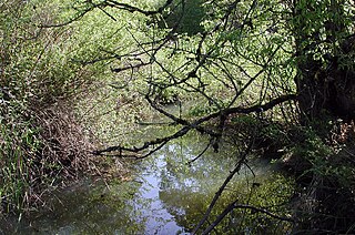
Fanno Creek is a 15-mile (24 km) tributary of the Tualatin River in the U.S. state of Oregon. Part of the drainage basin of the Columbia River, its watershed covers about 32 square miles (83 km2) in Multnomah, Washington, and Clackamas counties, including about 7 square miles (18 km2) within the Portland city limits.

<span class="mw-page-title-main">San Tan Valley, Arizona</span> Unincorporated community in the state of Arizona, United States

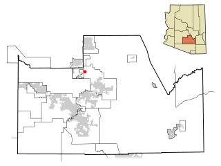
San Tan Valley is an unincorporated community and census-designated place in northern Pinal County, Arizona, United States. With 99,894 residents as of the 2020 census, it is the largest unincorporated community in Pinal County.

Tualatin Hills Park & Recreation District (THPRD) is a special parks district located in the eastern part of Washington County in the U.S. state of Oregon. Created in 1955, the district covers all of the city of Beaverton and many of those communities surrounding Beaverton in the Portland metropolitan area. The district covers an area of 50 square miles (130 km2) and serves a population of about 220,000, making it the largest parks district in Oregon. Tualatin Hills operates over 200 facilities totaling 2,100 acres (850 ha), including eight swimming centers. The district has an annual budget of $40 million and is overseen by a five-person board of directors.

<span class="mw-page-title-main">Tualatin Valley Fire and Rescue</span> Regional fire district in Oregon

Tualatin Valley Fire & Rescue (TVF&R) is a special-purpose government fire fighting and emergency services district in the Portland metropolitan area of Oregon. Established in 1989 with a merger between Washington County Fire District 1 and the Tualatin Rural Fire Protection District, it primarily provides fire and emergency medical services in eastern Washington County, but also provides services in neighboring Multnomah, Clackamas, and Yamhill counties. It serves unincorporated areas along with the cities of Beaverton, Tigard, Tualatin, West Linn, Wilsonville, and Sherwood, among others. With over 400 firefighters and 27 fire stations, the district is the second largest fire department in the state and has an annual budget of $197 million.

References

  1. "ArcGIS REST Services Directory". United States Census Bureau. Retrieved October 12, 2022.
  2. 1 2 U.S. Geological Survey Geographic Names Information System: Bull Mountain, Oregon
  3. 1 2 "Census Population API". United States Census Bureau. Retrieved October 12, 2022.
  4. Tims, Dana (April 12, 2011). "Washington County's 2010 Census data include a few surprises". The Oregonian . Retrieved April 12, 2011.
  5. "About TVF&R". Tualatin Valley Fire & Rescue. Retrieved March 13, 2014.
  6. "QuickFacts: Bull Mountain CDP, Oregon". U.S. Census Bureau. Retrieved September 3, 2023.
  7. "Census of Population and Housing". Census.gov. Retrieved June 4, 2016.
  8. Oregon Revised Statutes, Chapter 195 — Local Government Planning Coordination
  9. Oregon Revised Statutes, Chapter 222 — City Boundary Changes; Mergers; Consolidations; Withdrawal
  10. 1 2 Testimony submitted for the Annexation Hearing of July 27, 2004
  11. 1 2 Minutes of the Annexation Hearing of July 27, 2004
  12. OCVA Jan 2005 Newsletter
  13. "City of Tigard Resolution 04-64" (PDF). Archived from the original (PDF) on September 28, 2007. Retrieved February 9, 2007.
  14. 1 2 "Nov 2004 Election Results for Washington County, Oregon". Archived from the original on November 17, 2004. Retrieved February 9, 2007.
  15. Friends of Bull Mountain v. City of Tigard, 208 Or.App. 189, 144 P.3d 965 (2006)
  16. http://www.co.washington.or.us/deptmts/at/election/results/nov06.htm Archived 2007-01-16 at the Wayback Machine co.washington.or.us
  17. Bull Mountain Community Plan Archived September 27, 2007, at the Wayback Machine
  18. Jerry Krummel News Release 8 August 2006 [ dead link ]
General