Laurel, Oregon

Last updated

Laurel, Oregon
Laurel Valley Store - Oregon.JPG
Laurel Valley Store
USA Oregon location map.svg
Red pog.svg
Laurel, Oregon
Location within the state of Oregon
Usa edcp location map.svg
Red pog.svg
Laurel, Oregon
Laurel, Oregon (the United States)
Coordinates: 45°25′6.42″N122°59′30.37″W / 45.4184500°N 122.9917694°W / 45.4184500; -122.9917694
Country United States
State Oregon
County Washington
Settled1872
Elevation
[1]
197 ft (60 m)
Time zone UTC-8 (Pacific (PST))
  Summer (DST) UTC-7 (PDT)
GNIS feature ID1122976 [1]

Laurel is an unincorporated community in Washington County, Oregon, United States. Settled in 1872, the community is located between Hillsboro and Newberg, in the southern portion of the Tualatin Valley in the foothills of the Chehalem Mountains. The community retains its agricultural heritage. [2] Laurel is served by the Hillsboro School District and includes the century-old Laurel Valley Store building, which is in the process of being turned into a restaurant. As an unincorporated community, Laurel has no defined boundaries or population statistics of its own.

Contents

History

When Euro-American settlers came to what is now Washington County, the area was inhabited by the Atfalati Native American group. Smallpox epidemics struck the Atfalati and by the mid-1830s, only 10 percent of the tribe was left. An 1855 government treaty removed the remaining Atfalati to the Grand Ronde Indian Reservation, where there are still about 20 individuals who identify themselves as Atfalati. [3]

In 1872, the Mulloy family settled the area that is now Laurel. [4] Laurel received its name in the spring of 1879 when a number of citizens in the surrounding area met at the Union Schoolhouse, which was located a quarter mile east of the crossroads, to petition for a post office. C. W. Williams, who then lived on what was later the Mainland place, suggested the name of Laurel and there being many trees in the vicinity that they thought were Laurel trees, the name seemed appropriate and was accepted. (Later it was discovered that those were Madrone trees and not Laurel trees.) In May 1879, the Laurel post office was established with Alfred Mulloy, Sr. as postmaster. [4] Mail was delivered once per week until 1881 when deliveries increased to twice per week. [4] The population was 150 people in 1880, but dropped to 29 in the 1900 census. [5] The post office was closed in 1935. [6]

The Laurel Valley Store was opened in 1893 by Gus, Maud, and Jacob Messinger. In 1913 Ewell and Ella Turner purchased the store and in 1913 moved the store building and attached residence a short distance South and erected the present Laurel store building with residence attached. [7] The last manager of the store was Hyun Chung Lee who in 2017 sold the store to Sean and Quin Denfeld. Renovation work is currently in progress.

On June 14, 1856 the Laurel School District became the third elementary district formed in Washington County. The first building, a small one-room schoolhouse was built in 1858 and was located north of the Laurel intersection. In 1881 the present location was chosen for a new building and in 1925 the current building was built with an addition made in 1952. In 1962 voters of Laurel and Farmington View voted to consolidate the districts and Laurel's students were moved to Farmington. Seventh and eighth graders went to a junior high school in Hillsboro. Laurel School was made into apartments. [8]

A telephone line was extended to Laurel in 1904 from Hillsboro with four customers. [4] The population grew to 50 residents in 1910. [5]

In 1923, Laurel Community Hall was constructed for about $5,000. The purpose of the hall was "to promote sociability and friendship amongst its members and all people of the community." Finis Brown was the founder. The hall was dedicated on February 2, 1924; the mortgage was paid off in 1928. 400 people came to one of the fund raising chicken dinners and they paid $1.00 each. The hall has been used as a school gym, dance hall, Farmers Union meeting site, school Christmas programs and graduations, family gatherings, and is now the location of the Laurel Valley School of Dance. [4]

Churches

In 1876, community members started a congregation at Mountain Top with W.C. Kantner as preacher. [9] A Baptist church was also started that year by the Brown, Steventon, Shamly, and Messinger families. [4] The Mulloy family donated 2 acres (8,100 m2) to the church in 1878 for a chapel and cemetery, and a church was built and named the Mount Olive Baptist Church during the summer. [4] The cemetery was laid out in 1880. [4]

Church in the community Laurel, Oregon church.JPG
Church in the community

Laurel Church had its beginnings around 1888 when J.M. Beaumont, an Evangelical preacher, started preaching at the Baptist church. [4] [9] In 1892, the church was transferred to the Hillsboro mission of the church from the Newberg mission. [9] In 1897, Rosilla and George Hathorn donated land and a new church was built, named Bethany United Evangelical Church. [9] In 1800, the United Brethren Church was organized by Phillip Otterbein, with the churches merging in 1946. [9]

In 1947, Lester Moore began as the church's first full-time pastor. [9] On September 22, 1948, the original church building burned down. [9] A new structure was erected, and a dedication ceremony was held on January 29, 1950. [9] In 1960, a new parsonage was added, followed by an expansion started in 1974. The multi-purpose building where services are now held was dedicated in 1997. [9]

Present

The community has several agricultural farms and plant nurseries, although most of its residents commute to Portland, Hillsboro, or Beaverton for work. The Laurel Valley School of Dance has provided dance lessons in the Laurel Hall for over 30 years. [10] The old school building has been turned into the Laurel Apartments. Children attend schools in the Hillsboro School District, with Farmington View serving as the elementary school. [11] Fire protection services are provided by Washington County Fire District 2. [12]

The two main cross streets in Laurel are SW Laurel Road, and SW Campbell Road. These used to be Laurel Road North, Laurel Road South, Laurel Road East, and Laurel Road West. [7] These were changed to their present name when the county got rid of the old route/box number of addresses and implemented the present street address system, which is more common in the western United States. Laurel is located along the Washington County Scenic Loop. [7]

At the northwest corner of the main intersection in Laurel is the largest contiguous walnut orchard in Oregon's Washington County.[ citation needed ] Laurel Valley Store is located at the same intersection and has been in operation since 1893. [7] [13] The current two-story building was constructed in 1913. [14]

Related Research Articles

<span class="mw-page-title-main">Tigard, Oregon</span> City in Oregon, United States

Tigard is a city in Washington County, Oregon, United States. The population was 54,539 at the 2020 census. As of 2007, Tigard was the state's 12th largest city. Incorporated in 1961, the city is located south of Beaverton and north of Tualatin, and is part of the Portland metropolitan area. Interstate 5 and Oregon Route 217 are the main freeways in the city, with Oregon Route 99W and Oregon Route 210 serving as other major highways. Public transit service is provided by TriMet, via several bus routes and the WES Commuter Rail line.

<span class="mw-page-title-main">Cedar Mill, Oregon</span> Unincorporated community in the state of Oregon, United States

Cedar Mill is a suburb in the Portland, Oregon metropolitan area of the United States; it is a census-designated place and an unincorporated community in Washington County, north of U.S. Route 26 and west of the Willamette Stone. It received its name from a sawmill on Cedar Mill Creek, which cut Western Redcedars that were once the dominant tree in the area. The mill's pond was near the intersection of 119th and Cornell Road, and could still be seen into the 1960s, although the mill itself had ceased operating in 1891. The name was established in 1874 with the opening of a U.S. post office named Cedar Mill. As of the 2010 census, the community population was 14,546.

<span class="mw-page-title-main">Hillsboro, Oregon</span> City in Oregon, United States

Hillsboro is the fifth-largest city in the U.S. state of Oregon and is the county seat of Washington County. Situated in the Tualatin Valley on the west side of the Portland metropolitan area, the city hosts many high-technology companies, such as Intel, locally known as the Silicon Forest. At the 2020 census, the city's population was 106,447.

Portland Community College (PCC) is a public community college in Portland, Oregon. It is the largest post-secondary institution in the state and serves residents in the five-county area of Multnomah, Washington, Yamhill, Clackamas, and Columbia counties. As of the 2021–2022 academic year, PCC enrolls more than 50,000 full-time (40%) and part-time (60%) students.

<span class="mw-page-title-main">Tualatin Valley</span> Farming and suburban region southwest of Portland, Oregon

The Tualatin Valley is a farming and suburban region southwest of Portland, Oregon. The valley is formed by the meandering Tualatin River, a tributary of the Willamette River at the northwest corner of the Willamette Valley, east of the Northern Oregon Coast Range. Most of the valley is located within Washington County, separated from Portland by the Tualatin Mountains. Communities in the Tualatin Valley include Banks, Forest Grove, Cornelius, Hillsboro, Aloha, Beaverton, Sherwood, Tigard, and Tualatin.

<span class="mw-page-title-main">Orenco, Oregon</span> Neighborhood in Washington County, Oregon, United States

Orenco is a former company town in Washington County, Oregon, United States, located between Hillsboro and Aloha. The former community of Orenco now forms the Orenco neighborhood in Hillsboro, which is the site of the Orenco Station housing development.

<span class="mw-page-title-main">Oregon Route 219</span> Highway in Oregon

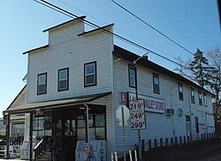
Oregon Route 219 is an Oregon state highway which runs between the cities of Hillsboro and Woodburn, Oregon, in the United States. The Hillsboro-Silverton Highway continues further south to Silverton, signed as OR 214. The highway mainly serves local residents and agricultural traffic; despite its proximity to the Portland area it lies outside the Portland Urban Growth Boundary and so maintains its character as a country road.

The Tualatin Valley Highway No. 29 is an Oregon highway which passes through the Tualatin Valley, between the cities of McMinnville and Beaverton. Between McMinnville and Forest Grove, the highway is signed as Oregon Route 47; between Forest Grove and Beaverton it is signed as Oregon Route 8. Oregon 8 becomes Canyon Road in Beaverton east of Hocken Road.

<span class="mw-page-title-main">Hillsboro School District</span> School district in Oregon, United States

The Hillsboro School District 1J is a unified school district located in Hillsboro, Oregon, United States. The district operates 26 elementary schools, four middle schools, and four high schools. Founded in 1851, the school district covers Hillsboro, Scholls, Reedville, North Plains, West Union, and other area communities. Total enrollment as of the 2019–2020 school year is 20,269 students, the fourth largest in the state.

<span class="mw-page-title-main">Laurelwood, Oregon</span> Unincorporated community in the state of Oregon, United States

Laurelwood is an unincorporated community in Washington County, Oregon, United States. The community is located southwest of the Portland metropolitan area near Oregon Route 47 along Laurelwood Road, to the east of the city of Gaston and Wapato Lake. Laurelwood, a farming community, has a population of approximately 500 people. Settled in the 1860s, the community was home to Laurelwood Academy from 1904 until 2007. A large portion of the community is of the Seventh-day Adventist faith.

<span class="mw-page-title-main">West Union, Oregon</span> Unincorporated community in the state of Oregon, United States

West Union is an unincorporated community in Washington County, Oregon, United States. Founded in 1851, the community had the first school district in the county; it also contains the oldest cemetery in the state and the oldest Baptist church west of the Rocky Mountains. It is located north of Hillsboro near the intersection of West Union Road and Cornelius Pass Road north of the Sunset Highway. The name comes from a grove of five oak trees that was used as a meeting place of early settlers, or the "union of the west." West Union had a post office from 1874 to 1894.

<span class="mw-page-title-main">Tualatin Plains</span> Region in Oregon, United States

The Tualatin Plains are a prairie area in central Washington County, Oregon, United States. Located around the Hillsboro and Forest Grove areas, the plains were first inhabited by the Atfalati band of the Kalapuya group of Native Americans. Euro-American settlement began in the 1840s.

<span class="mw-page-title-main">Glencoe, Oregon</span> Unincorporated community in the state of Oregon, United States

Glencoe is a neighborhood and former community in Washington County, Oregon, United States. Founded in 1842, the town, which was north of Hillsboro, died off after 1910 when neighboring North Plains was created to the west. Most of Glencoe is now a part of North Plains. Glencoe gives its name to the road connecting Hillsboro to North Plains, as well as the name of the second high school built in Hillsboro, Glencoe High School.

<span class="mw-page-title-main">Dilley, Oregon</span> Unincorporated community in the state of Oregon, United States

Dilley is an unincorporated community in Washington County, Oregon, United States. It is located south of Forest Grove and north of the city of Gaston on Oregon Route 47 in the Portland metropolitan area. Settled in the late 1840s, the community was platted in 1874 after the arrival of the railroad. The population of the area in 2000 was approximately 2,000.

<span class="mw-page-title-main">Oregon Chorale</span>

The Oregon Chorale is an American concert choir based in Hillsboro in the U.S. state of Oregon. Founded in 1985 as the Washington County Chorale, the 60 person group performs in the Portland metropolitan area, as well as tours in Europe. The group presents music ranging from classical and opera music to folk and contemporary numbers.

<span class="mw-page-title-main">Farmington, Oregon</span> Unincorporated community in the state of Oregon, United States

Farmington is an unincorporated community in Washington County, Oregon, United States. It is located on the Tualatin River, a tributary of the Willamette, about eight miles southwest of Beaverton, at the intersection of Oregon Route 10 and River Road. It is about two miles east of the junction of OR 10 with Oregon Route 219. Farmington was one of the earliest settlements in Oregon and was prominent for a time as an important milling and grain-shipping point on the Tualatin when steamships were the principal means of shipping grain along the Willamette River. Farmington was the site of an early Christian Church, founded by 1845 pioneers in Sarah and Philip Harris, who arrived in Oregon via the Meek Cutoff. At that time the locale was called "Bridgeport". Baptisms were in the Tualatin River.

<span class="mw-page-title-main">David Thomas Lenox</span> American judge

David Thomas Lenox was an American pioneer who settled in the Oregon Country where he organized the first Baptist Church west of the Rocky Mountains. A native of New York, he lived in Illinois and Missouri before he was captain of the first wagon train over the Oregon Trail to what became the state of Oregon. He also organized several schools and churches, and served as a judge and justice of the peace. In Oregon, he settled on the Tualatin Plains near what is now Hillsboro and later lived in Eastern Oregon.

<span class="mw-page-title-main">Mountaindale, Oregon</span> Unincorporated community in the state of Oregon, United States

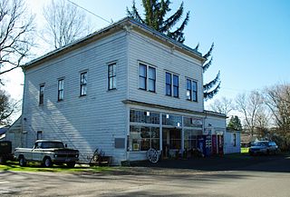
Mountaindale is an unincorporated community in Washington County, Oregon, United States, about four miles northwest of North Plains. Settled in the 1850s, the small community was the longtime home of the Mountaindale Store. The area is part of Washington County Fire District 2.

<span class="mw-page-title-main">Sonrise Church</span> Church in Oregon, United States

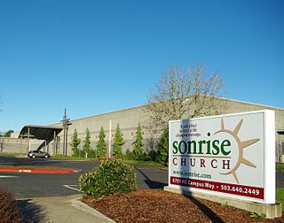
Sonrise Church is a Conservative Baptist church in Hillsboro in the U.S. state of Oregon. Founded in 1980 as Sonrise Baptist Church, the church is located in the Orenco neighborhood and has about 1,200 worshipers at its main campus, a former industrial building.

<span class="mw-page-title-main">Tualatin Valley Fire and Rescue</span> Regional fire district in Oregon

Tualatin Valley Fire & Rescue (TVF&R) is a special-purpose government fire fighting and emergency services district in the Portland metropolitan area of Oregon. Established in 1989 with a merger between Washington County Fire District 1 and the Tualatin Rural Fire Protection District, it primarily provides fire and emergency medical services in eastern Washington County, but also provides services in neighboring Multnomah, Clackamas, and Yamhill counties. It serves unincorporated areas along with the cities of Beaverton, Tigard, Tualatin, West Linn, Wilsonville, and Sherwood, among others. With over 400 firefighters and 27 fire stations, the district is the second largest fire department in the state and has an annual budget of $197 million.

References

  1. 1 2 "Laurel, Oregon". Geographic Names Information System . United States Geological Survey, United States Department of the Interior . Retrieved July 29, 2008.
  2. Mandel, Michelle. Scenic sojourn. The Oregonian , November 4, 1999.
  3. "Lookout" (PDF). Laurel Community Church. Retrieved July 2, 2010.[ permanent dead link ]
  4. 1 2 3 4 5 6 7 8 9 Mulloy, E.C. "Laurel receives post office in 1879 after long wait". Hillsboro Argus , October 19, 1976, Communities, p. 12.
  5. 1 2 Moffat, Riley Moore (1996). Population History of Western U.S. Cities and Towns, 1850-1990. Scarecrow Press. p. 212.
  6. Benson, Robert L. (October 19, 1976). "Business and Industry: Post offices, zip codes listed". Hillsboro Argus . p. 11.
  7. 1 2 3 4 Gardner, Fran. Laurel Valley Store has survived nearly a Century. The Oregonian , August 1, 1991.
  8. "Farmington View School History". Hillsboro School District. Archived from the original on January 30, 2010. Retrieved December 23, 2009.
  9. 1 2 3 4 5 6 7 8 9 Felton, Charles. "Evangelical mission work started Laurel Church in early 1870s". Hillsboro Argus , October 19, 1976, Schools and Churches, p. 6.
  10. Luedloff, Rebecca. Neighborhood Roundup – Metro West Hillsboro. The Oregonian , July 26, 2007.
  11. Farmington View Elementary Attendance Boundary Area effective fall 2008. Archived 2008-10-29 at the Wayback Machine Hillsboro School District. Retrieved on July 29, 2008.
  12. Tareen, Sophia. Fire district will lay off one-third of its staff. The Oregonian , November 25, 2004.
  13. Luedloff, Rebecca. Neighborhood Roundup – Metro West Hillsboro. The Oregonian , November 23, 2006.
  14. "Site Information: Laurel Valley Store". Oregon Historic Sites Database. Oregon Parks and Recreation Department. Retrieved August 23, 2008.