Scholls, Oregon

Last updated

Scholls, Oregon
Scholls Grange - Scholls, Oregon.JPG
Scholls Grange
USA Oregon location map.svg
Red pog.svg
Scholls, Oregon
Location within the state of Oregon
Usa edcp location map.svg
Red pog.svg
Scholls, Oregon
Scholls, Oregon (the United States)
Coordinates: 45°24′29″N122°55′20″W / 45.40806°N 122.92222°W / 45.40806; -122.92222
Country United States
State Oregon
County Washington
Elevation
151 ft (46 m)
Time zone UTC-8 (Pacific (PST))
  Summer (DST) UTC-7 (PDT)
ZIP code
97140
Area code(s) 503 and 971
GNIS feature ID1158471 [1]

Scholls, Oregon is an unincorporated community in Washington County, Oregon, United States. It is located along the southern shore of the Tualatin River, near the intersection of Oregon Routes 210 and 219. Scholls is located approximately seven miles north of Newberg, seven miles west of Tigard and eight miles south of Hillsboro. The area around Scholls is primarily agricultural.

Contents

History

Groner Elementary School Groner Elementary School - Scholls, Oregon.JPG
Groner Elementary School

According to Oregon Geographic Names , the community was named after local pioneer Peter Scholl, who took up a donation land claim in 1847. Scholls was once the site of an important ferry (Scholls Ferry) crossing the Tualatin River between Scholls and nearby Kinton. While the ferry has long since been replaced with a bridge, OR 210 is still known locally as Scholls Ferry Road.

Peter Scholl was a relative of Daniel Boone, probably related through Boone's grandson Alphonso Boone, an Oregon pioneer who built Boones Ferry. A general store has operated in the community since the 1890s, and was purchased by the Petrich family in 1964. [2] The original Petrichs General Store burned down in 1994. [2]

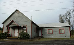
"Scholls Ferry" post office was established in 1871, and the name changed to "Scholls" in 1895. Scholls' ZIP Code is 97123.

Campo Azul

Campo Azul was a migrant camp located on a farm near Scholls (on the east side of Scholls Ferry Road, on the north bank of the Tualatin River). The camp, which was founded in the 1970s, was named for the color of the housing units which were on the 133-acre (0.54 km2) farm. Historically farmworkers, and in some cases their children, lived on the farm and worked on surrounding area farms. For many decades, as many as 90 or so adults and children lived at the camp. According to The Oregonian, the camp had initially been considered as a location for the New Thought church Living Enrichment Center. [3] Upon the death of Loraine Boggs, the ownership of the camp was in dispute. [4] Only after various legal negotiations was ownership of the farm settled. [5] The farm was sold in 2004, and by 2009 the new owners began operating a U-pick Pumpkin Patch and a livestock sheep operation. Today, the farm is also a rustic venue for private events and celebrations; and a place for community farming. [6]

Related Research Articles

<span class="mw-page-title-main">Tigard, Oregon</span> City in Oregon, United States

Tigard is a city in Washington County, Oregon, United States. The population was 54,539 at the 2020 census, making it the 12th most populous city in Oregon. Incorporated in 1961, the city is located south of Beaverton and north of Tualatin, and is part of the Portland metropolitan area. Interstate 5 and Oregon Route 217 are the main freeways in the city, with Oregon Route 99W and Oregon Route 210 serving as other major highways. Public transit service is provided by TriMet, via several bus routes and the WES Commuter Rail line.

<span class="mw-page-title-main">Washington County, Oregon</span> County in Oregon, United States

Washington County is one of 36 counties in the U.S. state of Oregon and part of the Portland metropolitan area. The 2020 census recorded the population as 600,372, making it the second most populous county in the state and most populous "Washington County" in the United States. Hillsboro is the county seat and largest city, while other major cities include Beaverton, Tigard, Cornelius, Banks, Gaston, Sherwood, North Plains, and Forest Grove, the county's oldest city. Originally named Twality when created in 1843, the Oregon Territorial Legislature renamed it for the nation's first president in 1849 and included the entire northwest corner of Oregon before new counties were created in 1854. The Tualatin River and its drainage basin lie almost entirely within the county, which shares its boundaries with the Tualatin Valley. It is bordered on the west and north by the Northern Oregon Coast Range, on the south by the Chehalem Mountains, and on the north and east by the Tualatin Mountains, or West Hills.

<span class="mw-page-title-main">Cedar Hills, Oregon</span> Unincorporated community in the state of Oregon, United States

Cedar Hills is a census-designated place and neighborhood in Washington County, Oregon, United States south of U.S. Route 26 and west of Oregon Route 217 and within the Portland metropolitan area. Construction began in 1946.

<span class="mw-page-title-main">Cedar Mill, Oregon</span> Unincorporated community in the state of Oregon, United States

Cedar Mill is a suburb in the Portland, Oregon metropolitan area of the United States; it is a census-designated place and an unincorporated community in Washington County, north of U.S. Route 26 and west of the Willamette Stone. It received its name from a sawmill on Cedar Mill Creek, which cut Western Redcedars that were once the dominant tree in the area. The mill's pond was near the intersection of 119th and Cornell Road, and could still be seen into the 1960s, although the mill itself had ceased operating in 1891. The name was established in 1874 with the opening of a U.S. post office named Cedar Mill. As of the 2020 census, the community population was 17,259.

<span class="mw-page-title-main">Durham, Oregon</span> City in Oregon, United States

Durham is a city in Washington County, Oregon, United States. Incorporated in 1966, the city is surrounded by Tigard and Tualatin and is adjacent to the Bridgeport Village shopping complex. The population was 1,351 at the 2010 census.

<span class="mw-page-title-main">Garden Home–Whitford, Oregon</span> CDP in Oregon, United States

Garden Home-Whitford is a census-designated place (CDP) consisting of the neighborhoods of Garden Home and the smaller Whitford area in Washington County, Oregon, United States. They are located in the southwest hills of Portland, near Beaverton. As of the 2020 census, the CDP population was 7,081.

<span class="mw-page-title-main">Hillsboro, Oregon</span> City in Oregon, United States

Hillsboro is a city in the U.S. state of Oregon and is the county seat of Washington County. Situated in the Tualatin Valley on the west side of the Portland metropolitan area, the city hosts many high-technology companies, such as Intel, locally known as the Silicon Forest. The population was 106,447 at the 2020 census, making Hillsboro the fifth-most populous city in Oregon.

<span class="mw-page-title-main">Wilsonville, Oregon</span> City in Oregon, United States

Wilsonville is a city primarily in Clackamas County, Oregon, United States. A portion of the northern section of the city is in Washington County. It was founded as Boones Landing because of the Boones Ferry which crossed the Willamette River at the location; the community became Wilsonville in 1880. The city was incorporated in 1969 with a population of approximately 1,000. The population was 13,991 at the 2000 census, and grew to 19,509 as of 2010. Slightly more than 90% of residents at the 2000 census were white, with Hispanics comprising the largest minority group.

<span class="mw-page-title-main">Tualatin River</span> River in Oregon, United States

The Tualatin River is a tributary of the Willamette River in Oregon in the United States. The river is about 83 miles (134 km) long, and it drains a fertile farming region called the Tualatin Valley southwest and west of Portland at the northwest corner of the Willamette Valley. There are approximately 500,000 people residing on 15 percent of the land in the river's watershed.

<span class="mw-page-title-main">Tualatin Valley</span> Farming and suburban region southwest of Portland, Oregon

The Tualatin Valley is a farming and suburban region southwest of Portland, Oregon. The valley is formed by the meandering Tualatin River, a tributary of the Willamette River at the northwest corner of the Willamette Valley, east of the Northern Oregon Coast Range. Most of the valley is located within Washington County, separated from Portland by the Tualatin Mountains. Communities in the Tualatin Valley include Banks, Forest Grove, Cornelius, Hillsboro, Aloha, Beaverton, Sherwood, Tigard, and Tualatin.

<span class="mw-page-title-main">Oregon Route 210</span> Highway in Oregon

Oregon Route 210 is a state highway which runs between the community of Scholls, Oregon and the Raleigh Hills neighborhood west of Portland, terminating at the Sylvan overpass on Highway 26. It has become an important route for both commuters and agriculture through Washington County. Oregon Route 210 is signed from east-to-west; though in actuality it runs in a northeast-to-southwest direction.

<span class="mw-page-title-main">Oregon Route 219</span> Highway in Oregon

Oregon Route 219 is an Oregon state highway which runs between the cities of Hillsboro and Woodburn, Oregon, in the United States. The Hillsboro-Silverton Highway continues further south to Silverton, signed as OR 214. The highway mainly serves local residents and agricultural traffic, despite its proximity to the Portland area it lies outside the Portland Urban Growth Boundary, and maintains its character as a country road.

<span class="mw-page-title-main">Oregon Route 141</span> Highway in Oregon

Oregon Route 141, known as the Beaverton–Tualatin Highway No. 141, is an Oregon state highway which runs from the city of Wilsonville to the southern edge of Beaverton. The highway is 10.46 miles (16.83 km) long.

<span class="mw-page-title-main">Tualatin River National Wildlife Refuge</span> Wetlands and lowlands sanctuary in the U.S. state of Oregon

The Tualatin River National Wildlife Refuge is a 1,856 acres (751 ha) wetlands and lowlands sanctuary in the northwestern part of the U.S. state of Oregon. Established in 1992 and opened to the public in 2006, it is managed by the United States Fish and Wildlife Service. Located in southeastern Washington County, 15 miles (24 km) southwest of Portland, the refuge is bordered by Sherwood, Tualatin and Tigard. A newer area, extending into northern Yamhill County, is located further west near the city of Gaston surrounding the former Wapato Lake.

<span class="mw-page-title-main">Kinton, Oregon</span> Unincorporated community in the state of Oregon, United States

Kinton is an unincorporated community in Washington County, Oregon, United States. It is located near the northern shore of the Tualatin River, near the intersection of Oregon Route 210 and River Road, a major county arterial that runs northwest towards Hillsboro. Kinton is located approximately eight miles north of Newberg, six miles southwest of Beaverton, and seven miles southeast of Hillsboro. The community was once the site of a ferry crossing the Tualatin River between Kinton and nearby Scholls. While the ferry has long since been replaced with a bridge, OR 210 is still known locally as Scholls Ferry Road. Kinton is in Oregon's wine country, with several notable wineries in the area.

<span class="mw-page-title-main">Reedville, Oregon</span> Unincorporated community in the state of Oregon, United States

Reedville is an unincorporated community in Washington County, Oregon, United States, located between Hillsboro and Aloha. Oregon Route 8 runs through the area. The community is served by the Hillsboro School District, with some portions of the area within the city limits of Hillsboro.

<span class="mw-page-title-main">Jackson Bottom Wetlands Preserve</span> Protected area of Oregon

Jackson Bottom Wetlands Preserve in Hillsboro, Oregon, United States, is a 635-acre (257 ha) wetlands area along the Tualatin River in Washington County, Oregon. Located on the south end of the city along Highway 219, this lowland area is a designated Important Bird Area and hosts such birds as buffleheads, dusky Canada geese, and tundra swans.

Historic ferries in Oregon are water transport ferries that operated in Oregon Country, Oregon Territory, and the state of Oregon, United States. These ferries allowed people to cross bodies of water, mainly rivers such as the Willamette in the Willamette Valley, and the Columbia, in order to transport goods, move people, and further communications until permanent bridges were built to allow faster crossing of the water. The early ferries were used by wagons and pedestrians, while later ones transported trains and then automobiles. Oregon has a few automobile ferries still in operation.

<span class="mw-page-title-main">Dilley, Oregon</span> Unincorporated community in the state of Oregon, United States

Dilley is an unincorporated community in Washington County, Oregon, United States. It is located south of Forest Grove and north of the city of Gaston on Oregon Route 47 in the Portland metropolitan area. Settled in the late 1840s, the community was platted in 1874 after the arrival of the railroad.

<span class="mw-page-title-main">Farmington, Oregon</span> Unincorporated community in the state of Oregon, United States

Farmington is an unincorporated community in Washington County, Oregon, United States. It is located on the Tualatin River, a tributary of the Willamette, about eight miles southwest of Beaverton, at the intersection of Oregon Route 10 and River Road. It is about two miles east of the junction of OR 10 with Oregon Route 219. Farmington was one of the earliest settlements in Oregon and was prominent for a time as an important milling and grain-shipping point on the Tualatin when steamships were the principal means of shipping grain along the Willamette River. Farmington was the site of an early Christian Church, founded by 1845 pioneers in Sarah and Philip Harris, who arrived in Oregon via the Meek Cutoff. At that time the locale was called "Bridgeport". Baptisms were in the Tualatin River.

References

  1. "Scholls, Oregon". Geographic Names Information System . United States Geological Survey, United States Department of the Interior.
  2. 1 2 Martin, Fiona (September 10, 1994). "Scholls residents mourn loss of landmark". The Oregonian. pp. A1.
  3. An Uncertain Future for Migrant Camp The Oregonian
  4. Housing Authority Minutes for December 3, 2002, regarding Campo Azul [ dead link ]
  5. Acquisition of Boggs Farm and Campo Azul
  6. Bill Oram (October 14, 2009). "Camp Azul migrant housing could become farm community | OregonLive.com". oregonlive.com. Retrieved November 22, 2012.