Reedville, Oregon

Last updated
Reedville, Oregon
Neighborhood
Harvey the Giant Rabbit at Harvey Marine - Reedville, Oregon.jpg
Harvey Rabbit on TV Highway
Hillsboro Beaverton Oregon - OpenStreetMap.png
Red pog.svg
Reedville, Oregon
Location within the Hillsboro area
USA Oregon location map.svg
Red pog.svg
Reedville, Oregon
Reedville, Oregon (Oregon)
Usa edcp location map.svg
Red pog.svg
Reedville, Oregon
Reedville, Oregon (the United States)
Coordinates: 45°29′52″N122°54′4″W / 45.49778°N 122.90111°W / 45.49778; -122.90111 Coordinates: 45°29′52″N122°54′4″W / 45.49778°N 122.90111°W / 45.49778; -122.90111
Country United States
State Oregon
County Washington County
City Hillsboro
Time zone UTC-8 (PST)
  Summer (DST) UTC-7 (PDT)
ZIP code
97003, 97078, and 97123
Area code(s) 503 and 971

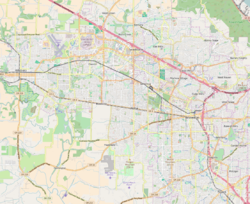
Reedville is an unincorporated community in Washington County, Oregon, United States, located between Hillsboro and Aloha. Oregon Route 8 (also known as the Tualatin Valley Highway) runs through the area. The community is served by the Hillsboro School District, with some portions of the area within the city limits of Hillsboro.

Contents

History

Reedville was named for Simeon Gannett Reed, who was a member of the Oregon Steam Navigation Company, and a prominent figure in Columbia River transportation in 1859-1879. Reed and business partner William S. Ladd operated an 8,000-acre (32 km2) plus hobby farm in the area where they raised livestock and held harness races. [1] His property became the endowment of Reed College after the death of his wife Amanda Reed. Reedville post office was established in 1877 and ran until 1954. [2]

In 2003, Hillsboro opened the Reedville Creek Park, which included the city’s first skate park. [3] By 2004, parts of the community had been annexed into Hillsboro, which led to readdressing of several streets from the county based street numbering to the Hillsboro-based numbering system. [4]

In 2016, ground broke on a new subdivision called Reed's Crossing in South Hillsboro. [5] It is located just south of the intersection of Oregon Route 8 and Cornelius Pass Road. A commercial center called Reed's Crossing Town Center and a 23 acre Reed's Crossing Greenway park are expected to be in the new subdivision.

Sites of interest

Related Research Articles

Aloha, Oregon Unincorporated community in the State of Oregon, United States

Aloha is a census-designated place and unincorporated community in Washington County, Oregon, United States. By road it is 10.9 miles (17.5 km) west of downtown Portland. As of the 2010 Census, the population was 49,425. Fire protection and EMS services are provided through Tualatin Valley Fire and Rescue. and Metro West Ambulance.

Hillsboro, Oregon City in Oregon, United States

Hillsboro is the fifth-largest city in the U.S. state of Oregon and is the county seat of Washington County. Situated in the Tualatin Valley on the west side of the Portland metropolitan area, the city hosts many high-technology companies, such as Intel, locally known as the Silicon Forest. At the 2020 census, the city's population was 106,447.

Tualatin River River in Oregon, United States

The Tualatin River is a tributary of the Willamette River in Oregon in the United States. The river is about 83 miles (134 km) long, and it drains a fertile farming region called the Tualatin Valley southwest and west of Portland at the northwest corner of the Willamette Valley. There are approximately 500,000 people residing on 15 percent of the land in the river's watershed.

Tualatin Valley Farming and suburban region southwest of Portland, Oregon

The Tualatin Valley is a farming and suburban region southwest of Portland, Oregon in the United States. The valley is formed by the meandering Tualatin River, a tributary of the Willamette River at the northwest corner of the Willamette Valley, east of the Northern Oregon Coast Range. Most of the valley is located within Washington County, separated from Portland by the Tualatin Mountains. Communities in the Tualatin Valley include Banks, Forest Grove, Cornelius, Hillsboro, Aloha, Beaverton, Sherwood, Tigard, and Tualatin.

Oregon Route 8 Highway in Oregon

Oregon Route 8, also known as Oregon Highway 8, is an Oregon state highway which serves the western suburbs of Portland. The road is locally known as Canyon Road and Tualatin Valley Highway, and travels through the center of the Tualatin Valley. Oregon 8 is located entirely within Washington County. The portion of the route from US 26 to Oregon Route 47 is part of the National Highway System, listed as a principal arterial.

Orenco, Oregon Neighborhood in Washington County, Oregon, United States

Orenco is a former company town in Washington County, Oregon, United States, located between Hillsboro and Aloha. The former community of Orenco now forms the Orenco neighborhood in Hillsboro, which is the site of the Orenco Station housing development.

Tualatin Valley Highway

The Tualatin Valley Highway No. 29 is an Oregon highway which passes through the Tualatin Valley, between the cities of McMinnville and Beaverton. Between McMinnville and Forest Grove, the highway is signed as Oregon Route 47; between Forest Grove and Beaverton it is signed as Oregon Route 8. Oregon 8 becomes Canyon Road in Beaverton east of Hocken Road.

Hillsboro School District School district in Oregon, United States

The Hillsboro School District 1J is a unified school district located in Hillsboro, Oregon, United States. The district operates 26 elementary schools, four middle schools, and four high schools. Founded in 1851, the school district covers Hillsboro, Scholls, Reedville, North Plains, West Union, and other area communities. Total enrollment as of the 2019–2020 school year is 20,269 students, the fourth largest in the state.

Tanasbourne, Oregon Neighborhood in Washington County, Oregon, United States

Tanasbourne, Oregon, is a neighborhood in Washington County, Oregon, where NW 185th Avenue and the Sunset Highway intersect. It is located within the Portland metropolitan area. The area sits between Beaverton and Hillsboro, and is generally considered to be south of U.S. 26, north of Walker Road, west of 158th, and east of Cornelius Pass Road. Adjacent to Aloha and part of the West Metro region, Tanasbourne has many shopping areas and is the former home of the defunct Tanasbourne Mall.

Noble Woods Park

Noble Woods Park is a wooded city park in Hillsboro, Oregon, United States. Located on approximately 40 acres (160,000 m2) along Rock Creek, the nature park with wetlands and forests is situated between West Baseline Road on the north and Southwest Borwick Road to the south near the Orenco neighborhood. The city acquired the land for the park in 1992 and opened the park in the eastern section of the city in 1998. Noble Woods has two entrances, a picnic area, and hiking trails.

West Union, Oregon Unincorporated community in the State of Oregon, United States

West Union is an unincorporated community in Washington County, Oregon, United States. Founded in 1851, the community had the first school district in the county; it also contains the oldest cemetery in the state and the oldest Baptist church west of the Rocky Mountains. It is located north of Hillsboro near the intersection of West Union Road and Cornelius Pass Road north of the Sunset Highway. The name comes from a grove of five oak trees that was used as a meeting place of early settlers, or the "union of the west." West Union had a post office from 1874 to 1894.

Tualatin Plains Region in Oregon, United States

The Tualatin Plains are a prairie area in central Washington County, Oregon, United States. Located around the Hillsboro and Forest Grove areas, the plains were first inhabited by the Atfalati band of the Kalapuya group of Native Americans. Euro-American settlement began in the 1840s.

Glencoe, Oregon Unincorporated community in the State of Oregon, United States

Glencoe is a neighborhood and former community in Washington County, Oregon, United States. Founded in 1842, the town, which was north of Hillsboro, died off after 1910 when neighboring North Plains was created to the west. Most of Glencoe is now a part of North Plains. Glencoe gives its name to the road connecting Hillsboro to North Plains, as well as the name of the second high school built in Hillsboro, Glencoe High School.

Cornelius Pass Road is an arterial road over Cornelius Pass in the Tualatin Mountains west of Portland, Oregon, United States, also extending several miles to the south. Running north–south, the road stretches between U.S. Route 30 (US 30) on the north and Kinnaman Street, just south of Oregon Route 8 (OR 8), on the south. The road passes through Washington and Multnomah counties, crossing the Tualatin Mountains at Cornelius Pass, 581 feet (177 m) above sea level. TriMet's MAX Light Rail line travels over the road on a bridge. The section between US 30 in Burlington and U.S. Route 26 in Hillsboro is Oregon Route 127 , known in the Oregon state highway system as Cornelius Pass Highway No. 127.

Rood Bridge Park

Rood Bridge Park is a municipal park in southeast Hillsboro, Oregon, United States. Opened in 1999, the park encompasses 60 acres (24 ha) on the north bank of the Tualatin River at its confluence with Rock Creek. Rood Bridge is near Hillsboro High School and sits across the river from Meriwether National Golf Course. The park is the city’s largest, and contains tennis courts, a meeting facility, trails, a canoe launch, and a rhododendron garden among other features.

Reedville Creek Park

Reedville Creek Park is a municipal park in the Reedville neighborhood of Hillsboro, Oregon, United States. Opened in 2003, the 9.6-acre (39,000 m2) park is along Cornelius Pass Road at Francis Street in the southeast area of the city. The park includes basketball courts, children’s play equipment, a picnic shelter, tennis courts, and sports fields among other amenities. Reedville Creek was the first and is the only park in Hillsboro with a skatepark.

Turner Creek Park

Turner Creek Park is a municipal park in Hillsboro in the U.S. state of Oregon. Opened about 1990, the 12.5-acre (51,000 m2) park is located in the middle of the city along Turner Creek near southwest 32nd Avenue between Tualatin Valley Highway and Main Street. The park includes a playground, restrooms, several sports facilities, and natural areas with trails.

Witch Hazel, Oregon Neighborhood in Washington County, Oregon, United States

Witch Hazel is a neighborhood of the city of Hillsboro in Washington County, Oregon, United States. Formerly an unincorporated community, and considered a separate populated place by the United States Geological Survey, it is on the Tualatin Valley Highway and the Southern Pacific railroad line a mile (1.6 km) west of Reedville.

Tualatin Hills Park & Recreation District (THPRD) is a special parks district located in the eastern part of Washington County in the U.S. state of Oregon. Created in 1955, the district covers all of the city of Beaverton and many of those communities surrounding Beaverton in the Portland metropolitan area. The district covers an area of 50 square miles (130 km2) and serves a population of about 220,000, making it the largest parks district in Oregon. Tualatin Hills operates over 200 facilities totaling 2,100 acres (850 ha), including eight swimming centers. The district has an annual budget of $40 million and is overseen by a five-person board of directors.

Tualatin Valley Fire and Rescue Regional fire district in Oregon

Tualatin Valley Fire & Rescue (TVF&R) is a special-purpose government fire fighting and emergency services district in the Portland metropolitan area of Oregon. Established in 1989 with a merger between Washington County Fire District 1 and the Tualatin Rural Fire Protection District, it primarily provides fire and emergency medical services in eastern Washington County, but also provides services in neighboring Multnomah, Clackamas, and Yamhill counties. It serves unincorporated areas along with the cities of Beaverton, Tigard, Tualatin, West Linn, Wilsonville, and Sherwood, among others. With over 400 firefighters and 27 fire stations, the district is the second largest fire department in the state and has an annual budget of $197 million.

References

Reedville Creek Park Reedville Creek Park.JPG
Reedville Creek Park
  1. Terry, John. Oregon’s Trails: Reeds’ desires, riches yield premier legacy of learning. The Oregonian , July 6, 2003.
  2. McArthur, Lewis A.; Lewis L. McArthur (2003) [1928]. Oregon Geographic Names (Seventh ed.). Portland, Oregon: Oregon Historical Society Press. ISBN   0-87595-277-1.
  3. Readying the ramps. The Oregonian , November 14, 2002.
  4. Bermudez, Esmeralda. Reedville readies for readdressing. The Oregonian , April 29, 2004.
  5. Oregonian/OregonLive, Allan Brettman The. "Massive South Hillsboro project breaks ground; welcome mat out for 20,000 people". OregonLive.com. Retrieved 2019-01-26.
  6. "Harvey the Giant Rabbit". roadsideamerica.com. Retrieved 2006-11-04.
  7. "Reedville Creek Park". Parks & Facilities. City of Hillsboro. Archived from the original on 2008-10-19. Retrieved 2009-01-17.