
Blackford County is located in the east central portion of the U.S. state of Indiana. The county is named for Judge Isaac Blackford, who was the first speaker of the Indiana General Assembly and a long-time chief justice of the Indiana Supreme Court. Created in 1838, Blackford County is divided into four townships, and its county seat is Hartford City. Two incorporated cities and one incorporated town are located within the county. The county is also the site of numerous unincorporated communities and ghost towns. Occupying only 165.58 square miles (428.9 km2), Blackford County is the fourth smallest county in Indiana. As of the 2010 census, the county's population was 12,766 people in 5,236 households. Based on population, the county is the 8th smallest county of the 92 in Indiana. Although no interstate highways are located in Blackford County, three Indiana state roads cross the county, and an additional state road is located along the county's southeast border. The county has two railroad lines. A north–south route crosses the county, and intersects with a second railroad line that connects Hartford City with communities to the west.

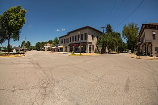
Hartford City is a city in the U.S. state of Indiana, and the county seat of Blackford County. Located in the northeast central portion of the state, the small farming community experienced a 15-year “boom” beginning in the late 1880s. The Indiana Gas Boom was caused by the discovery of natural gas in the area, and it caused the community to transition from an agricultural economy to one that also included manufacturing. The boom brought residents, retail establishments, and craftspeople. The increased population meant construction of new roads, schools, and churches. After the boom came a long period of growth and stability. Agriculture remained as the fundamental industry.
Charlestown is a city in Clark County, Indiana, United States. The population was 7,585 at the 2010 census.

Gas City is a city in Grant County, Indiana, along the Mississinewa River. The population was 5,965 at the 2010 census.

Sweetser is a town in Franklin, Pleasant and Richland townships, Grant County, Indiana, United States. The population was 1229 at the 2010 census.

Bloomfield is a town in Richland Township, Greene County, Indiana, United States. The population was 2,405 at the 2010 census. The city is the county seat of Greene County.

Plainfield is a town in Guilford, Liberty, and Washington townships, Hendricks County, Indiana, United States. The population was 27,631 at the 2010 census, and in 2019 the estimated population was 35,287.

Morocco is a town in Beaver Township, Newton County, in the U.S. state of Indiana. The population was 1,129 at the 2010 census.
Rushville is a city in Rushville Township, Rush County, in the U.S. state of Indiana. The population was 6,341 at the 2010 census. The city is the county seat of Rush County. It, like the county, was named in honor of Dr. Benjamin Rush, who signed the Declaration of Independence.

Talbot is an unincorporated community in Hickory Grove Township, Benton County, in the U.S. state of Indiana. It is part of the Lafayette, Indiana Metropolitan Statistical Area.
Collamer is an unincorporated community in Cleveland Township, Whitley County, Indiana, United States, located on the Eel River and at the intersection of Indiana State Road 14 and Whitley County road 900 W. Smith Rambo platted the town February 9, 1846. Collamer is named after Jacob Collamer, 13th United States Postmaster General.

Harrison Township is one of nine townships in Wells County, Indiana, United States. As of the 2010 census, its population was 8,531 and it contained 3,702 housing units.
Stockdale is an unincorporated community in Paw Paw Township, Wabash County and Miami County, in the U.S. state of Indiana.

Brimfield is an unincorporated community in Orange Township, Noble County, in the U.S. state of Indiana.

Converse is an unincorporated community in Jackson Township, Blackford County, in the U.S. state of Indiana. Although not much of the community remains, the U.S. Geological Survey considers it a populated place. The community existed as a "flag" station along a railroad, and is named after railroad executive Joel N. Converse. Like many communities in Blackford County, this village declined after the end of the Indiana Gas Boom, which ended in the early 20th century.
Renner is an extinct American village in Indiana's Blackford County. Although Renner has been listed as a “populated place” by the U.S. Geological Survey, this description is misleading. Renner was a railroad stop on the Pittsburgh, Cincinnati and St. Louis Railroad. The land around the railroad stop was originally used to supply timber for railroad crossties, and eventually became a livestock farm. Housing for the families of the employees of the livestock farm was also located nearby. Although it is not known for certain, Renner is thought to have been named for railroad executive John W. Renner. Renner was an executive of the Pittsburgh, Cincinnati and St. Louis Railroad, and later the Pennsylvania Railroad, and retired with over 50 years of railroad experience. Another community, Rennerdale, Pennsylvania, was named in his honor in 1895.
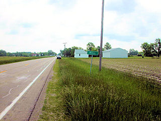
Roll is an unincorporated community in Washington Township, Blackford County, in the U.S. state of Indiana. Nearly all of the community's businesses have been closed for years. Although the Blackford County Historical Society lists Roll as a ghost town, homes are still maintained in the area, and it is still listed as a populated place by the U.S. Geological Survey. The rural community is located on Indiana State Road 18, about one mile west of its intersection with Indiana State Road 3.

Donaldson is an unincorporated community in West Township, Marshall County, Indiana.

Perryville is an unincorporated community in Hartford Township, Adams County, in the U.S. state of Indiana.
Hoover Mill is an unincorporated community in Clay Township, Wayne County, in the U.S. state of Indiana.

