Trenton, Indiana

Last updated
Trenton, Indiana
Trenton Indiana.jpg
Trenton, Indiana
Map of Indiana highlighting Blackford County.svg
Blackford County's location in Indiana
Map of Blackford County, Indiana.svg
Red pog.svg
Trenton
Location in Blackford County
Coordinates: 40°27′00″N85°14′20″W / 40.45000°N 85.23889°W / 40.45000; -85.23889 Coordinates: 40°27′00″N85°14′20″W / 40.45000°N 85.23889°W / 40.45000; -85.23889
Country United States
State Indiana
County Blackford
Township Jackson
Established1847
Elevation
[1]
899 ft (274 m)
Time zone UTC-5 (Eastern (EST))
  Summer (DST) UTC-4 (EDT)
ZIP code
47348
Area code 765
FIPS code 18-76436 [2]
GNIS feature ID 444871

Trenton is an unincorporated town in Jackson Township, Blackford County, in the U.S. state of Indiana. [3] Nearly all of the community's businesses have been closed for many years. Although the Blackford County Historical Society lists this community as a ghost town, homes are still maintained in the area. [4]

Contents

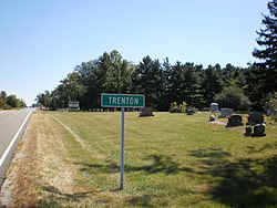
Trenton is located east of Hartford City on Indiana State Road 26. Platted in 1845, it is one of the older communities in Blackford County. [5] The community had its own Post Office from 1856 until 1907. [6] Because there was another Trenton in Randolph County during the 19th century, Blackford County’s Trenton post office used the name Priam. [5] [7] Therefore, many older maps show the community as "Priam" instead of Trenton.

Trenton participated in the Indiana Gas Boom, and had two of Blackford County's many gas companies (Marion Creek Natural Gas Company and Trenton Natural Gas Company) that existed during the 1890s. [8] The Gas Boom gradually ended during the beginning of the 20th century, and many small communities never recovered. During the next few decades, the quality of automobiles and roads improved—indirectly contributing to the decline of many small communities as consumers drove to larger cities. [9]

Trenton, Indiana Trenton, Indiana.jpg
Trenton, Indiana

History

Trenton is located in Jackson Township in Blackford County. Jackson Township's population was only 154 in 1840, as there was no rail connection and the land suffered from poor drainage. [10] Trenton was platted on January 20, 1845, by Robert H. Laning, Ezekiel Laning, Basel Anderson and William Cortright. [5] Cortright was the landowner. [11]

When Blackford County's railroads were constructed in the late 1860s, Trenton was bypassed—as the nearest rail line was four miles south of the small town. During the 1880s, the community was boosted by the Indiana Gas Boom, and the community had two gas companies of its own. Eventually, the community had as many as 25 residences. In addition to its post office, the village also had a tannery, blacksmith shops, saw and tile mills and its own physicians. [10] It also had two churches, two general stores and a drug store. [11] The Trenton school was constructed in the 1870s, and its last version closed in 1964. [12]

The Gas Boom gradually ended during the beginning of the 20th century, and many small communities never recovered. Improvements to the automobile and highways, which coincided with the end of the Gas Boom, may have also contributed to the decline of the county's smaller communities as consumers became willing to travel to larger cities. [13]

Geography

Located in the Jackson Township portion of Blackford County, Trenton is situated on Indiana State Road 26. The community is located 60 miles (97 km) south of Fort Wayne and 80 miles (130 km) northeast of Indianapolis. [14] Trenton is part of East Central Indiana and Northern Indiana. Future Northern Indiana, including what became Jackson Township and Trenton, was flattened by two glaciers millions of years ago. [15] These glaciers are also responsible for the rich Blackford County farmland, which includes the land surrounding Trenton. [16]

Climate and weather

Hartford City, Indiana (approximately 7 miles west of Trenton)
Climate chart (explanation)
J
F
M
A
M
J
J
A
S
O
N
D
 
 
2
 
 
33
18
 
 
1.9
 
 
38
22
 
 
2.8
 
 
49
31
 
 
3.4
 
 
62
41
 
 
3.8
 
 
72
50
 
 
4.3
 
 
81
60
 
 
4.3
 
 
84
63
 
 
4.1
 
 
82
62
 
 
2.9
 
 
76
54
 
 
2.5
 
 
65
43
 
 
3.4
 
 
50
34
 
 
2.7
 
 
38
23
Average max. and min. temperatures in °F
Precipitation totals in inches
Source:The Weather Channel [17]
Metric conversion
J
F
M
A
M
J
J
A
S
O
N
D
 
 
50
 
 
1
−8
 
 
49
 
 
3
−6
 
 
71
 
 
9
−1
 
 
86
 
 
17
5
 
 
97
 
 
22
10
 
 
110
 
 
27
16
 
 
109
 
 
29
17
 
 
103
 
 
28
17
 
 
73
 
 
24
12
 
 
63
 
 
18
6
 
 
86
 
 
10
1
 
 
69
 
 
3
−5
Average max. and min. temperatures in °C
Precipitation totals in mm

Trenton has a typical Midwestern humid continental seasonal climate. There are four distinct seasons, with winters being cold with moderate snowfall, while summers can be warm and humid. [18] In recent years, average temperatures in nearby county seat Hartford City have ranged from a low of 18 °F (−8 °C) in January to a high of 84 °F (29 °C) in July, although a record low of −26 °F (−32 °C) was recorded in January 1994 and a record high of 103 °F (39 °C) was recorded in June 1988. Average monthly precipitation ranged from 1.94 inches (49 mm) in February to 4.33 inches (110 mm) in June. [17] The biggest snow storm in recent memory was the Great Blizzard of 1978, which occurred on January 26–27, 1978. A federal state of emergency was declared for Indiana at that time. [18]

Nearby cities

Related Research Articles

<span class="mw-page-title-main">Blackford County, Indiana</span> County in Indiana, United States

Blackford County is located in the east central portion of the U.S. state of Indiana. The county is named for Judge Isaac Blackford, who was the first speaker of the Indiana General Assembly and a long-time chief justice of the Indiana Supreme Court. Created in 1838, Blackford County is divided into four townships, and its county seat is Hartford City. Two incorporated cities and one incorporated town are located within the county. The county is also the site of numerous unincorporated communities and ghost towns. Occupying only 165.58 square miles (428.9 km2), Blackford County is the fourth smallest county in Indiana. As of the 2020 census, the county's population was 12,112. Based on population, the county is the 8th smallest county of the 92 in Indiana. Although no interstate highways are located in Blackford County, three Indiana state roads cross the county, and an additional state road is located along the county's southeast border. The county has two railroad lines. A north–south route crosses the county, and intersects with a second railroad line that connects Hartford City with communities to the west.

<span class="mw-page-title-main">Hartford City, Indiana</span> City in Indiana, United States

Hartford City is a city in the U.S. state of Indiana, and the county seat of Blackford County. Located in the northeast central portion of the state, the small farming community underwent a dramatic 15-year economic boom beginning in the late 1880s. The Indiana Gas Boom resulted from the discovery and exploitation of natural gas in the area. The rural economy was transformed to one that included manufacturing. The boom attracted workers and residents, retail establishments, and craftspeople. The increased population was a catalyst for the construction of roads, schools, and churches. After the boom came a long period of growth and stability. Agriculture remained as the basis for the economy.

<span class="mw-page-title-main">Montpelier, Indiana</span> City in Indiana, United States

Montpelier is a city in Harrison Township, Blackford County, in the U.S. state of Indiana. This small rural community, the county's first to be platted, was established by settlers from Vermont, and is named after Vermont's capital city of Montpelier.

<span class="mw-page-title-main">East Central Indiana</span>

East Central Indiana is a region in Indiana east of Indianapolis, Indiana, and borders the Ohio state line. The Indiana Gas Boom, which took place during the 1890s, changed much of the area from small agricultural communities to larger cities with economies that included manufacturing. Companies such as Ball Corporation and Overhead Door once had their headquarters in the region. Glass manufacturing was the first industry to be widespread in the area, because of the natural gas. As the glass industry faded, many of the skilled workers became employed at auto parts factories in cities such as Muncie and Anderson. With the decline of the American automobile industry, East Central Indiana became part of the Rust Belt. Many communities have been forced to reinvent themselves with a focus on services or a return to agriculture.

<span class="mw-page-title-main">Harrison Township, Blackford County, Indiana</span> Township in Indiana, United States

Harrison Township is one of four townships in Blackford County, Indiana. As of the 2010 census, its population was 2,640 and it contained 1,196 housing units. The township was named after William Henry Harrison, hero of the Battle of Tippecanoe, former governor of the Indiana Territory, and ninth President of the United States.

<span class="mw-page-title-main">Jackson Township, Blackford County, Indiana</span> Township in Indiana, United States

Jackson Township is one of four townships in Blackford County, Indiana. As of the 2010 census, its population was 1,354 and it contained 596 housing units. The township was named after Andrew Jackson, the Brevet Major General of the Battle of New Orleans and the seventh President of the United States.

<span class="mw-page-title-main">Licking Township, Blackford County, Indiana</span> Township in Indiana, United States

Licking Township is one of four townships in Blackford County, Indiana. As of the 2010 census, its population was 7,899 and it contained 3,885 housing units. The township was named after Lick Creek and a salt lick in the area. The first settlers in what became Blackford County arrived in the Lick Creek area in 1831.

<span class="mw-page-title-main">Washington Township, Blackford County, Indiana</span> Township in Indiana, United States

Washington Township is one of four townships in Blackford County, Indiana. As of the 2010 census, its population was 873 and it contained 374 housing units. County Commissioners named the township after George Washington in 1833, and it was part of Jay County. In 1838, Washington Township became part of the newly organized Blackford County.

<span class="mw-page-title-main">Converse, Blackford County, Indiana</span> Unincorporated community in Indiana, United States

Converse is an unincorporated community in Jackson Township, Blackford County, in the U.S. state of Indiana. Although not much of the community remains, the U.S. Geological Survey considers it a populated place. The community existed as a "flag" station along a railroad, and is named after railroad executive Joel N. Converse. Like many communities in Blackford County, this village declined after the end of the Indiana Gas Boom, which ended in the early 20th century.

<span class="mw-page-title-main">Millgrove, Indiana</span> Unincorporated community in Indiana, United States

Millgrove is an unincorporated community in Jackson Township, Blackford County, in the U.S. state of Indiana. Nearly all of the community's businesses have been closed for many years. Although the Blackford County Historical Society lists this community as a ghost town, homes are still maintained in the area.

<span class="mw-page-title-main">Renner, Indiana</span> Ghost town in Indiana, United States

Renner is an extinct American village in Indiana's Blackford County. Although Renner has been listed as a “populated place” by the U.S. Geological Survey, this description is misleading. Renner was a railroad stop on the Pittsburgh, Cincinnati and St. Louis Railroad. The land around the railroad stop was originally used to supply timber for railroad crossties, and eventually became a livestock farm. Housing for the families of the employees of the livestock farm was also located nearby. Although it is not known for certain, Renner is thought to have been named for railroad executive John W. Renner. Renner was an executive of the Pittsburgh, Cincinnati and St. Louis Railroad, and later the Pennsylvania Railroad, and retired with over 50 years of railroad experience. Another community, Rennerdale, Pennsylvania, was named in his honor in 1895.

<span class="mw-page-title-main">Roll, Indiana</span> Unincorporated community in Indiana, United States

Roll is an unincorporated community in Washington Township, Blackford County, in the U.S. state of Indiana. Nearly all of the community's businesses have been closed for years. Although the Blackford County Historical Society lists Roll as a ghost town, homes are still maintained in the area, and it is still listed as a populated place by the U.S. Geological Survey. The rural community is located on Indiana State Road 18, about one mile west of its intersection with Indiana State Road 3.

<span class="mw-page-title-main">History of Hartford City, Indiana</span> City in Indiana, United States

Hartford City, Indiana, began in the late 1830s as a few log cabins clustered near a creek. The community became the county seat of Blackford County. Located in the north east-central portion of the state, the small farming community experienced a 15-year "boom" beginning in the late 1880s caused by the discovery of natural gas. The Indiana Gas Boom caused the community to transition from an agricultural economy to one that also included manufacturing. During the 1890s, Hartford City was the home of the nation's largest window glass company and the nation's largest producer of lantern globes.

<span class="mw-page-title-main">First Presbyterian Church (Hartford City, Indiana)</span> Historic church in Indiana, United States

The First Presbyterian Church of Hartford City is a Presbyterian church in Hartford City, Indiana, United States. The edifice is the oldest church building in a small city that at one time was a bustling community with as many as ten glass factories – and over 20 saloons. Located at the corner of High and Franklin Streets, the church is part of the Hartford City Courthouse Square Historic District. The church was added to the National Register of Historic Places in 1986.

<span class="mw-page-title-main">Hartford City Courthouse Square Historic District</span> Historic district in Indiana, United States

The Hartford City Courthouse Square Historic District is located in Hartford City, Indiana. Hartford City has a population of about 7,000 and is the county seat of Blackford County and the site of the county courthouse. The National Park Service of the United States Department of the Interior added the Hartford City Courthouse Square Historic District to the National Register of Historic Places on June 21, 2006 — meaning the buildings and objects that contribute to the continuity of the district are worthy of preservation because of their historical and architectural significance. The District has over 60 resources, including over 40 contributing buildings, over 10 non-contributing buildings, 1 contributing object, 8 non-contributing objects, and two other buildings that are listed separately in the National Register.

<span class="mw-page-title-main">Blackford County Courthouse</span> United States historic place

The Blackford County Courthouse is a historic building located in Hartford City, Indiana, the county seat of Blackford County. The building stands on a public square in the city's downtown commercial district. Built during the Indiana Gas Boom, most of the construction work was completed in 1894. The current courthouse was preceded by another courthouse building on the same site, which was declared inadequate by a judge in 1893, and was torn down. Following the condemnation of the original courthouse, the county's judicial activities were temporarily located in a building across the street.

<span class="mw-page-title-main">Mollie, Indiana</span> Extinct village in Indiana, United States

Mollie is an extinct American village in Blackford County, Indiana, that flourished during the Indiana Gas Boom from the 1880s until the 1920s. The region around Mollie experienced an economic "boom" period because of the discovery of gas and crude oil. Mollie was a stop along the Fort Wayne, Cincinnati, and Louisville Railroad—and happened to be near the region's oil fields, a convenient location for the area's oil workers.

<span class="mw-page-title-main">Timeline of Blackford County, Indiana</span>

This is a timeline and interactive map of Blackford County, Indiana. The timeline (below) lists important events in Blackford County history. An adjacent (right) interactive map contains links to various locations around the county.

<span class="mw-page-title-main">Hartford City Glass Company</span> American glass manufacturing company

Hartford City Glass Company was among the top three window glass manufacturers in the United States between 1890 and 1899, and continued to be one of the nation's largest after its acquisition. It was also the country's largest manufacturer of chipped glass, with capacity double that of its nearest competitor. The company's works was the first of eight glass plants that existed in Hartford City, Indiana during the Indiana Gas Boom. It became the city's largest manufacturer and employer, peaking with 600 employees.

References

Citations

  1. "US Board on Geographic Names". United States Geological Survey. 2007-10-25. Retrieved 2008-01-31.
  2. "U.S. Census website". United States Census Bureau . Retrieved 2008-01-31.
  3. "Trenton, Indiana". Geographic Names Information System . United States Geological Survey . Retrieved March 1, 2020.
  4. Blackford County Historical Society's "Ghost Towns in Blackford County, Indiana".
  5. 1 2 3 Biographical and historical record of Jay and Blackford Counties...., pp. 758.
  6. A History of Blackford County..., p. 17.
  7. "Post Offices". Randolph County Historical Society. Retrieved 2011-07-09.
  8. Blatchley, p. 405.
  9. A History of Blackford County..., p. 130.
  10. 1 2 Historic Landmarks Foundation of Indiana, p. 77.
  11. 1 2 A History of Blackford County..., p. 128.
  12. A History of Blackford County..., p. 132.
    • Greene, Dick (August 6, 1974). "Seen and Heard in Our Neighborhood". The Muncie Star. The automobile and improved roads affected Millgrove as it has many another community, making it easy for people to travel to larger communities, particularly to county seats, to do their trading. The need for local facilities declined as they became centralized in the more populous areas.
  13. Mileage calculated by Mapquest.
  14. A History of Blackford County..., pp. 8-9.
  15. A History of Blackford County..., p. 10.
  16. 1 2 "Monthly Averages for Hartford City, Indiana". The Weather Channel. Retrieved 2011-01-27.
  17. 1 2 Purdue University's Iclimate.org web site.

References