Hope Valley, Derbyshire

Last updated

The Hope Valley viewed from Mam Tor Hope Valley, Derbyshire.jpg
The Hope Valley viewed from Mam Tor

The Hope Valley is a rural area centred on the village of Hope, Derbyshire, in the Peak District in the northern Midlands of England.

Contents

The name also applies to the post town that includes the surrounding villages.

Valley

Looking over Hathersage from Higger Tor Hope valley 03.jpg
Looking over Hathersage from Higger Tor
Hope Valley, between Edale and Hope, with the Hope Valley Line visible Hope Valley, 09,05.jpg
Hope Valley, between Edale and Hope, with the Hope Valley Line visible

Although the Hope Valley appears to be a single valley, the name of the river changes several times. The head of the valley lies below Mam Tor at Castleton, widely regarded as the capital of the valley. From here, the Peakshole Water flows to Hope, where it enters the lower reaches of the River Noe, which has flowed from Edale. The Noe then flows to Shatton near Bamford, before entering the River Derwent, which has travelled about ten miles from Bleaklow. The valley is now technically the Derwent Valley, but the term "Hope Valley" is still used as the Derwent flows through Hathersage and Grindleford. Other streams in the area include the Burbage Brook, which runs down from Burbage Valley through Padley Gorge and into the River Derwent near Grindleford station.

The area is a popular tourist destination, particularly as the Hope Valley Line railway from Sheffield to Manchester runs through it, from the western end of the Totley Tunnel near Grindleford to the eastern end of the Cowburn Tunnel near Edale.

In the centre of the valley is a long-established cement factory, the UK's biggest, run by Hope Construction Materials. [1] It is somewhat infamous locally because it is a prominent industrial operation in the middle of a National Park and is very visible from many locations. However, the factory provides valuable local employment outside the tourism sector.

The Hope Valley College is the only secondary school in the Hope Valley. Castleton Church of England Primary School (one of several primary schools in the valley) and the surrounding area was featured in Channel 4's new (in October 2017) ident which shows images of the valley from Mam Tor. [2] [3]

History

There is evidence that Hope has been extremely significant in the region throughout its long history. The village is mentioned in the Domesday Book of 1086 as having both a priest and a church, the only place in north Derbyshire to have such status at the time. St. Peter's Church, opposite the Old Hall public house, dates from around the 13th century.

The parish of Hope covered two thirds of the Royal Hunting Forest of north Derbyshire and was one of the largest parishes in the country. From earlier times there are traces of a Roman fort at Brough, just to the east of the village. Its Roman name Navio was later replaced with the Old English word for fort, Brough. Many ancient relics from the site can be seen in Buxton Museum. It is thought that the fort was probably built to protect Roman lead-mining interests in the Peak District.

The village is built on the A6187 Sheffield to Castleton road, near the junction of the B6049 that runs northward from Tideswell to Edale. This minor road closely follows the route of the old Portway, which was an ancient trading route used by Jaggers, a local term for men driving packhorses carrying salt and other goods from Cheshire. Names such as Saltergate Lane and Jaggers Lane probably originate from this period.

Post town

The Hope Valley post town lies in the postal area of Sheffield. It encompasses the S32 and S33 postal districts, and includes the following villages: [4]

Related Research Articles

Rock climbing is a popular activity in the Peak District; particularly on edges such as Stanage or Froggatt. Generally the climbing style is free climbing and the rock is either gritstone or limestone. Climbing has been practised in the Peak District since the late 19th century; James W. Puttrell is generally credited with starting the sport. The first climbing guidebook to the area was Some Gritstone Climbs, by John Laycock, published in 1913. There are over 10,000 routes in the Peak District. One of the most famous Peak District climbers, and a pioneer of many new routes, is Ron Fawcett. The climb known as "Master's Edge", on Millstone Edge, near Hathersage, is a testament to his skill and strength. The climb is graded E7 6c and rises 19m up the near vertical edge.

The Upper Derwent Valley is an area of the Peak District National Park in England. It largely lies in Derbyshire, but its north eastern area lies in Sheffield, South Yorkshire. Its most significant features are the Derwent Dams, Ladybower, Derwent and Howden, which form Ladybower Reservoir, Derwent Reservoir and Howden Reservoir respectively.

<span class="mw-page-title-main">Mam Tor</span> Hill near Castleton in the High Peak of Derbyshire, England

Mam Tor is a 517 m (1,696 ft) hill near Castleton in the High Peak of Derbyshire, England. Its name means "mother hill", so called because frequent landslips on its eastern face have resulted in a multitude of "mini-hills" beneath it. These landslips, which are caused by unstable lower layers of shale, also give the hill its alternative name of Shivering Mountain.

<span class="mw-page-title-main">River Derwent, Derbyshire</span> River in Derbyshire, England

The Derwent is a river in Derbyshire, England. It is 50 miles (80 km) long and is a tributary of the River Trent, which it joins south of Derby. Throughout its course, the river mostly flows through the Peak District and its foothills.

<span class="mw-page-title-main">Derwent Reservoir (Derbyshire)</span> Reservoir in Derbyshire, England

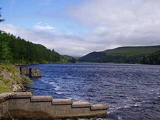
Derwent Reservoir is the middle of three reservoirs in the Upper Derwent Valley in the north of Derbyshire, England. It lies approximately 10 miles (16 km) from Glossop and 10 miles (16 km) from Sheffield. The River Derwent flows first through Howden Reservoir, then Derwent Reservoir and finally through Ladybower Reservoir. Between them they provide practically all of Derbyshire's water, as well as to a large part of South Yorkshire and as far afield as Nottingham and Leicester.

<span class="mw-page-title-main">River Noe</span> River in England

The River Noe is a tributary of the River Derwent in Derbyshire, England. It flows approximately 12 miles (19 km) from its source, the confluence of two streams running off Kinder Scout in the Peak District, east through Edale and then southeast through the village of Hope.

<span class="mw-page-title-main">Edale</span> Village and parish in the Peak District, England

Edale is a village and civil parish in the Peak District, Derbyshire, England, whose population was 353 at the 2011 Census. Edale, with an area of 7,030 acres (2,840 ha), is in the Borough of High Peak.

<span class="mw-page-title-main">Castleton, Derbyshire</span> Human settlement in England

Castleton is a village in the High Peak district of Derbyshire, England, at the western end of the Hope Valley on the Peakshole Water, a tributary of the River Noe, between the Dark Peak to the north and the White Peak to the south. The population was 642 at the 2011 Census.

<span class="mw-page-title-main">Hope, Derbyshire</span> Human settlement in England

Hope is a village and civil parish in the Derbyshire Peak District, in England. The population at the 2011 Census was 864. It lies in the Hope Valley, at the point where Peakshole Water flows into the River Noe. To the north, Win Hill and Lose Hill stand either side of the Noe.

<span class="mw-page-title-main">Hathersage</span> Village in Derbyshire, England

Hathersage is a village and civil parish in the Peak District in Derbyshire, England. It lies slightly to the north of the River Derwent, approximately 10 miles (16.1 km) south-west of Sheffield.

<span class="mw-page-title-main">High Peak, Derbyshire</span> Place in England

High Peak is a local government district with borough status in Derbyshire, England. The borough compromises high moorland plateau in the Dark Peak area of the Peak District National Park. The district stretches from Holme Moss in the north to Sterndale Moor in the south and from Hague Bar in the west to Bamford in the east. The population of the borough taken at the 2011 Census was 90,892. The borough is unusual in having two administrative centres for its council, High Peak Borough Council. The offices are based in both Buxton and Glossop. The borough also contains other towns including Chapel-en-le-Frith, Hadfield, New Mills and Whaley Bridge.

<span class="mw-page-title-main">Bamford</span> Human settlement in England

Bamford is a village in the Peak District, Derbyshire, England, close to the River Derwent. To the north-east is Bamford Edge, and to the north-west the Ladybower, Derwent and Howden Reservoirs. At the 2011 census, it had a population of 1,241.

<span class="mw-page-title-main">Win Hill</span>

Win Hill is a hill north west of Bamford in the Derbyshire Peak District of England. Its summit is 462 m (1,516 ft) above sea level and it is bounded by the River Derwent to the east, the River Noe to the south west and Ladybower Reservoir to the north, with a ridge running north west linking it to Kinder Scout. The Roman road from Glossop over the Snake Pass crosses the ridge to the north and descends to Hope and the old Roman base of Brough in the Hope Valley, with the Hope Cross, a marker post dating from 1737, at the highest point of the road.

<span class="mw-page-title-main">Peakshole Water</span> River in England

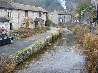
Peakshole Water is a stream in the Derbyshire Peak District named after its source, Peak Cavern. It flows through the village of Castleton to join the River Noe in nearby Hope. Despite its name, much of its flow actually emerges from the Russet Well, a resurgence in a garden on the east side of the gorge below the main Peak Cavern entrance, described as the "main resurgence of the Castleton area", which drains a series of swallets on the other side of the Pennine watershed below Rushup Edge. The resurgence has been explored by cave divers to a depth of 82 feet (25 m) but further exploration was halted by a constriction.

<span class="mw-page-title-main">A6187 road</span>


The A6187 is a secondary route in the Peak District, Derbyshire and South Yorkshire, England. It starts in Castleton, runs in an easterly direction past Fox House Inn where it joins the A625 road. It is 13.6 miles long.

<span class="mw-page-title-main">Higger Tor</span> Tor in England

Higger Tor or Higgar Tor is a gritstone tor in the Dark Peak, in the north of the Peak District National Park in England. It overlooks the Burbage Valley and the Iron Age hill fort of Carl Wark to the southeast.

<span class="mw-page-title-main">Burbage Brook</span> River in England

Burbage Brook is an upper tributary stream of the River Derwent in the Peak District of England.

<span class="mw-page-title-main">St John the Baptist's Church, Bamford</span> Church in Bamford, England

St John the Baptist church is a C of E church in Bamford in the Hope Valley, Derbyshire, England.

<span class="mw-page-title-main">Derwent Valley Heritage Way</span> Long distance footpath in England

The Derwent Valley Heritage Way (DVHW) is a 55 miles (89 km) waymarked footpath along the Derwent Valley through the Peak District. The walk starts from Ladybower Reservoir in the Peak District National Park via Chatsworth, the scenery around the Derbyshire Dales, and through the Derwent Valley Mills World Heritage Site. It follows the Riverside Path through Derby and continues onwards to the historic inland port of Shardlow. Journey's end is at Derwent Mouth where the River Derwent flows into the River Trent.

<span class="mw-page-title-main">Vale of Edale</span> Valley in the Peak District of England

The Vale of Edale is the upper valley of the River Noe, in the Derbyshire Peak District of England. The village of Edale lies in the middle of the valley.

References

  1. "Hope Construction Materials celebrates successful first year". Global Cement. 6 January 2014. Retrieved 16 June 2014.
  2. "Castleton C of E Primary School - Home". www.castletonschool.co.uk. Retrieved 8 August 2018.
  3. "Channel 4 reveals 'Giant' rebranding with new idents designed to "champion diversity and provoke change"". Radio Times. Retrieved 8 August 2018.
  4. "Postcode Finder | Post Office". www.postoffice.co.uk. Retrieved 8 August 2018.

Coordinates: 53°20′50″N1°44′44″W / 53.34727°N 1.74550°W / 53.34727; -1.74550