It is proposed that this article be deleted because of the following concern: If you can address this concern by improving, copyediting, sourcing, renaming, redirecting, or merging the page, please edit this page and do so. You may remove this message if you improve the article or otherwise object to deletion for any reason. Although not required, you are encouraged to explain why you object to the deletion, either in your edit summary or on the talk page. If this template is removed, do not replace it . The article may be deleted if this message remains in place for seven days, i.e., after 00:27, 13 February 2026 (UTC). Find sources: "Hopewell, Lee County, Alabama" – news · newspapers · books · scholar · JSTOR |
This article relies largely or entirely on a single source .(February 2024) |
The topic of this article may not meet Wikipedia's general notability guideline .(February 2024) |
Hopewell, Alabama | |
|---|---|
 Hopewell United Methodist Church | |
 Hopewell  Hopewell | |
| Coordinates: 32°31′30″N85°18′09″W / 32.52500°N 85.30250°W | |
| Country | United States |
| State | Alabama |
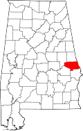
| County | Lee |
| Elevation | 686 ft (209 m) |
| Time zone | UTC-6 (CST) |
| • Summer (DST) | UTC-6 (EDT) |
| GNIS feature ID | 156493 [1] |
Hopewell is an unincorporated community in Lee County, Alabama, United States.