The Gold Country is a historic region in the northern portion of the U.S. state of California, that is primarily on the western slope of the Sierra Nevada. It is famed for the mineral deposits and gold mines that attracted waves of immigrants, known as the 49ers, during the 1849 California Gold Rush.
Antioch is a neighborhood of Nashville located approximately 12 miles (19 km) southeast of Downtown Nashville. It is served by the Metropolitan Government of Nashville and Davidson County.

State Route 49 is a north–south state highway in the U.S. state of California that passes through many historic mining communities of the 1849 California gold rush and it is known as the Golden Chain Highway. The highway's creation was lobbied by the Mother Lode Highway Association, a group of locals and historians seeking a single highway to connect many relevant locations along the Gold Rush to honor the 49ers. One of the bridges along SR 49 is named for the leader of the association, Archie Stevenot.
Unison is an unincorporated community village in Loudoun County, Virginia. It is located approximately five miles from Middleburg in the Loudoun Valley close to the Fauquier County border.

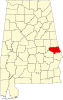
Salem is an unincorporated community east-centrally located in Lee County, Alabama, United States. It lies along U.S. Routes 280 and 431 between Opelika and Phenix City. It is part of the Auburn Metropolitan Area.

The Bottle is a community located in the northern corporate limits of Auburn, Alabama, United States. The Bottle is located at the intersection of U.S. Highway 280 and Alabama Highway 147, five miles (8.0 km) north of downtown Auburn, and adjacent to the Auburn University North Fisheries Research Complex.
You Bet is a small unincorporated community in Nevada County, California. You Bet is located in the Sierra Nevada foothills, 7 miles (11.3 km) east of Grass Valley and 5.5 miles (8.9 km) northeast of Chicago Park.

Bolling is an unincorporated community in Butler County, Alabama, United States.

Havilah is an unincorporated community in Kern County, California. It is located in the mountains between Walker Basin and the Kern River Valley, 5 miles (8.0 km) south-southwest of Bodfish at an elevation of 3,136 feet (956 m).
Shands was a settlement in Nevada County in the U.S. state of California, located on the San Juan Ridge, about 21⁄2 miles west of Graniteville, and just northeast of the intersection of the present-day North Bloomfield – Graniteville Road and Spanish Mine Road, near Cherry Hill. The site is at an elevation of 4636 feet.
Cherokee is a former gold mining community in Nevada County, California. The community has also been known as Patterson, Melrose, and Tyler. It is located on the San Juan Ridge about 4 miles east of North San Juan. Its elevation is 2,516 ft (767 m) above sea level.
Little York is the name of one of the first gold mining towns established in Nevada County, California as well as the name of the township in which it was situated. The town was located on the Lowell Ridge between Steephollow Creek and the Bear River, about 13 miles east of Nevada City, California and about 1 mile southwest of Dutch Flat, California at an elevation of about 2800 feet.
Greenwood, also known as Laflin,, is a ghost town in Lawrence County, South Dakota, United States. According to the book “Deadwood Saints and Sinners” by Jerry L. Bryant and Barbara Fifer, Robert Flormann died of pneumonia in Nome, Alaska, on July 4, 1900 and is buried in Seattle, page 168.
Maitland, originally called Garden City and sometimes misspelled Midland, is a ghost town in Lawrence County, South Dakota, United States. It was a mining community that boomed during the Black Hills Gold Rush, but was abandoned by about 1915.
Galena is an unincorporated community in Lawrence County, South Dakota, United States. It is often considered to be a ghost town, even though a few families still live in the area. It is not tracked by the U.S. Census Bureau.
Arkwright was an unincorporated community in Shelby County, Alabama, United States. The community lies near the banks of the Coosa River and is now within the city limits of Vincent. Arkwright was founded in 1907 and was named for Preston Stanley Arkwright, who served as founder and president of Georgia Railway and Power Company and as an official with the Atlanta, Birmingham and Atlantic Railway. At one point, the community was home to a railroad station, post office, bank, cotton gin, gristmill, general store, furniture store, and school. The post office was in operation from 1909 to 1926. In 1924, the railroad company raised the railroad bed, eliminating the need for a depot. The population soon began to decline and the post office was closed shortly afterwards. The Arkwright Baptist Church and Arkwright Heritage Area, which includes multiple structures and cemeteries, were added to the Alabama Register of Landmarks and Heritage in 2011.
Sulphur Springs is an unincorporated community in DeKalb County, in the U.S. state of Alabama.
Hybart is an unincorporated community in Monroe County, in the U.S. state of Alabama. Hybart is located at 31°49′36″N87°22′56″W. It is located at the intersection of Alabama State Route 41 and Monroe County Road 56, in the northwestern part of Monroe County, just a short distance from its border with Wilcox County, Alabama. Hybart is the host of a locally famous Alabama turkey hunting competition called the Butterball which has appeared in Mobile Bay Magazine. The area is also known for being a good hunting spot for whitetail deer, turkey, quail, dove, and duck. Hybart is on the northwestern edge of the Red Hills region of southwestern Alabama, a hilly, wooded, and still largely undeveloped part of the state, geologically distinct from the Gulf Coastal Plain to its south, and the Black Belt region to its north. Within the Red Hills region, the Forever Wild Land Trust of Alabama owns two large tracts of land a few miles to the southeast of Hybart. Recreational opportunities in these tracts include hunting, woods road hiking/exploration, wildflower viewing, photography, and bird and wildlife watching. The Red Hills tracts are open to visitors year-round.

Ralston is an unincorporated community in McIntyre Township, Lycoming County, Pennsylvania, United States. The community is located along Pennsylvania Route 14, 18.5 miles (29.8 km) north of Williamsport. Ralston has a post office with ZIP code 17763.
Poplar is an unincorporated community in Mitchell County, North Carolina, United States. The community is located along North Carolina Highway 197 (NC 197), at the banks of the Hollow Poplar Creek and between the southern slopes of the Unaka Range and the North Toe River. It is also the last community along the CSX Blue Ridge Subdivision before crossing into Tennessee towards Erwin.