Marvyn, Alabama

Last updated
Marvyn, Alabama
MarvynAL.JPG
Marvyn's abandoned service station located at the intersection of Alabama Highway 51 and U.S. Highway 80.
USA Alabama location map.svg
Red pog.svg
Marvyn
Usa edcp location map.svg
Red pog.svg
Marvyn
Coordinates: 32°26′21″N85°21′51″W / 32.43917°N 85.36417°W / 32.43917; -85.36417 Coordinates: 32°26′21″N85°21′51″W / 32.43917°N 85.36417°W / 32.43917; -85.36417
Country United States
State Alabama
County Lee
Elevation
499 ft (152 m)
Time zone UTC-6 (CST)
  Summer (DST) UTC-6 (EDT)
GNIS feature ID122351 [1]

Marvyn, also spelled Marvin, is an unincorporated community located in southern Lee County, Alabama, United States. It sits at the crossroads of Alabama Highway 51 and U.S. Highway 80, and in the Lee County "panhandle" between Russell County and Macon County. It is part of the Columbus, Georgia-Alabama Metropolitan Area.

Contents

History

Marvyn was originally located in Russell County, but was granted to Lee County in 1923 in exchange for Phenix City. A soil series is named after Marvyn, as it was first described in the area. The Marvyn soil series is described as a "fine-loamy, siliceous, thermic Typic Hapludults. [2]

Geography

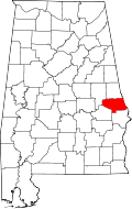
Marvyn is located at the junction of U.S. Route 80 and Alabama State Route 51 in the southern part of the county. Via US-80, Phenix City is 22 mi (35 km) east, and Tuskegee is 22 mi (35 km) west. Via AL-51, Opelika, the county seat of Lee County, is 15 mi (24 km) north, and Hurtsboro is 15 mi (24 km) south.

Demographics

Historical population
CensusPop.Note
1880 241
U.S. Decennial Census [3]

Marvyn appeared on the U.S. Census in 1880 with a population of 241 residents. At the time it was located in Russell County. This was the only time it was listed on the census rolls as a separate community.

Related Research Articles

<span class="mw-page-title-main">Montgomery County, Alabama</span> County in Alabama, United States

Montgomery County is located in the State of Alabama. As of the 2020 census, its population was 228,954, making it the fifth-most populous county in Alabama. Its county seat is Montgomery, the state capital. Montgomery County is included in the Montgomery, AL Metropolitan Statistical Area.

<span class="mw-page-title-main">Lee County, Alabama</span> County in Alabama, United States

Lee County is a county located in east central Alabama. As of the 2020 census the population was 174,241. The county seat is Opelika, and the largest city is Auburn. The county was established in 1866 and is named for General Robert E. Lee (1807–1870), who served as General in Chief of the Armies of the Confederate States in 1865. Lee County comprises the Auburn-Opelika, AL Metropolitan Statistical Area, which is included in the Columbus-Auburn-Opelika, GA-AL Combined Statistical Area.

<span class="mw-page-title-main">Macon County, Alabama</span> County in Alabama, United States

Macon County is a county located in the east central part of the U.S. state of Alabama. As of the 2020 census, the population was 19,532. Its county seat is Tuskegee. Its name is in honor of Nathaniel Macon, a member of the United States Senate from North Carolina.

<span class="mw-page-title-main">Russell County, Alabama</span> County in Alabama, United States

Russell County is a county in the southeastern part of the U.S. state of Alabama. As of the 2020 census, the population was 59,183. Its county seat is Phenix City. Its name is in honor of Colonel Gilbert C. Russell, who fought in the wars against the Creek Indians.

<span class="mw-page-title-main">Muscogee County, Georgia</span> County in Georgia, United States

Muscogee County is a county located on the central western border of the U.S. state of Georgia; its western border with the state of Alabama is formed by the Chattahoochee River. As of the 2020 census, the population was 206,922. Its county seat and only city is Columbus, with which it has been a consolidated city-county since the beginning of 1971.

<span class="mw-page-title-main">Chattahoochee County, Georgia</span> County in Georgia, United States

Chattahoochee County, also known as Cusseta-Chattahoochee County, is a county located on the western border in central Georgia. As of the 2020 census, the population was 9,565. The county seat is Cusseta, with which the county shares a consolidated city-county government. The city of Cusseta remains a geographically distinct municipality within Chattahoochee County. The county was created on February 13, 1854.

<span class="mw-page-title-main">Phenix City, Alabama</span> City in Alabama, United States

Phenix City is a city in Lee and Russell counties in the U.S. state of Alabama, and the county seat of Russell County. As of the 2020 Census, the population of the city was 38,817.

<span class="mw-page-title-main">Smiths Station, Alabama</span> City in Alabama, United States

Smiths Station is a city in Lee County, Alabama. It is part of the Columbus metropolitan area, Georgia. At the time of the 2000 census, it was still a census-designated place (CDP), and its population was 6,756. The area that incorporated as Smiths Station in 2001 was much smaller than the CDP, and contained a population of 4,926 by the 2010 census. Smiths Station, known to locals as "Smiths", is a bedroom community of Columbus, Georgia and Phenix City, Alabama. Smiths Station High School has an enrollment of over 1,800 students and is the 11th-largest high school in the state.

<span class="mw-page-title-main">Columbus, Georgia</span> Consolidated city-county in the United States

Columbus is a consolidated city-county located on the west-central border of the U.S. state of Georgia. Columbus lies on the Chattahoochee River directly across from Phenix City, Alabama. It is the county seat of Muscogee County, with which it officially merged in 1970. Columbus is the second-largest city in Georgia, and fields the state's fourth-largest metropolitan area. At the 2020 census, Columbus had a population of 206,922, with 328,883 in the Columbus metropolitan area. The metro area joins the nearby Alabama cities of Auburn and Opelika to form the Columbus–Auburn–Opelika Combined Statistical Area, which had an estimated population of 486,645 in 2019.

<span class="mw-page-title-main">U.S. Route 80</span> Numbered Highway in the United States

U.S. Route 80 or U.S. Highway 80 (US 80) is a major east–west United States Numbered Highway in the Southern United States, much of which was once part of the early auto trail known as the Dixie Overland Highway. As the "0" in the route number indicates, it was originally a cross-country route, from the Pacific Ocean to the Atlantic Ocean. Its original western terminus was at Historic US 101 in San Diego, California. However, the entire segment west of Dallas, Texas, has been decommissioned in favor of various Interstate Highways and state highways. Currently, the highway's western terminus is at an interchange with Interstate 30 (I-30) on the Dallas–Mesquite, Texas city line. Its eastern terminus is in Tybee Island, Georgia near the Atlantic Ocean. Between Jonesville, Texas and Kewanee, Mississippi, US 80 runs parallel to or concurrently with Interstate 20. It also currently runs through Dallas, Texas; Shreveport, Louisiana; Jackson, Mississippi; Montgomery, Alabama; Columbus, Georgia; Macon, Georgia; and Savannah, Georgia.

<span class="mw-page-title-main">U.S. Route 280</span> Highway in the United States

U.S. Route 280 is a spur of U.S. Highway 80. It currently runs for 392 miles (631 km) from Blitchton, Georgia, at US 80 to Birmingham, Alabama at I-20/I-59. For much of its route, US 280 travels through rural areas and smaller cities in southern Georgia and east central Alabama. Once the highway approaches Birmingham, it is a major suburban route. Numerous shopping centers are located on US 280 throughout northern Shelby County and southern Jefferson County.

<span class="mw-page-title-main">Beauregard, Alabama</span> Unincorporated community in Alabama, United States

Beauregard is an unincorporated community located in central Lee County, Alabama, United States. It is located east of Auburn and south of Opelika.

<span class="mw-page-title-main">U.S. Route 80 in Alabama</span> U.S. Highway in Alabama

U.S. Route 80 (US 80) is a major U.S. Highway in the American state of Alabama. The Alabama Department of Transportation internally designates the majority of US 80 throughout the state as State Route 8 (SR 8), save for parts of the route throughout Selma and near the Mississippi border. Serving as the main east to west highway through Alabama's Black Belt region, US 80 became well known as the main route for the 1965 Selma to Montgomery marches; it was the route along which the Civil Rights demonstrators walked, from Selma to Alabama, and the Edmund Pettus Bridge in Selma was the site of Bloody Sunday. The highway was also once a major transcontinental highway reaching from Tybee Island, Georgia, to San Diego, California, but has since been truncated to Dallas, Texas because it was largely replaced by the Interstate Highway System.

<span class="mw-page-title-main">Interstate 85 in Alabama</span> Section of Interstate Highway in Alabama, United States

Interstate 85 (I-85) is a part of the Interstate Highway System that runs from Montgomery, Alabama, to Petersburg, Virginia. In Alabama, the Interstate Highway runs 80 miles (130 km) from I-65 in Montgomery northeast to the Georgia state line near Valley. I-85 is the primary highway between Montgomery and Atlanta. The Interstate also connects Montgomery with Tuskegee, Auburn, Opelika, and, indirectly, Phenix City and Columbus, Georgia.

<span class="mw-page-title-main">Alabama State Route 26</span>

State Route 26 (SR 26) is a 14.560-mile-long (23.432 km) state highway in Russell County in the southeastern part of the U.S. state of Alabama. The western terminus of the highway is at its intersection with SR 51, and the eastern terminus of the highway is at its intersection with U.S. Route 431 (US 431) at the unincorporated community of Seale, approximately 20 miles (32 km) southwest of Phenix City.

<span class="mw-page-title-main">Alabama State Route 186</span>

State Route 186 is a 3.829-mile (6.162 km) state highway in Macon County. The western terminus of the route is at an interchange with Interstate 85 (I-85) approximately 9 miles (14 km) west of Auburn. The eastern terminus of the route is at its junction with US 29/US 80 approximately 8 miles (13 km) east of Tuskegee.

<span class="mw-page-title-main">Seale, Alabama</span> Unincorporated community in Alabama, United States

Seale is an unincorporated community in Russell County, Alabama, United States. It was the county seat from 1868 until 1935, and is currently home to Russell County High School and middle school. The former Russell County courthouse, built in 1868, is located in the town.

<span class="mw-page-title-main">Columbus–Auburn–Opelika combined statistical area</span> CSA in the United States

The Columbus–Auburn–Opelika, GA–AL Combined Statistical Area is a trading and marketing area made up of six counties in Georgia and two in Alabama. The statistical area includes two metropolitan areas: the Columbus metropolitan area and the Auburn–Opelika metropolitan area. As of the 2020 Census, the CSA had a population of 483,104.

<span class="mw-page-title-main">Pittsview, Alabama</span> Unincorporated community in Alabama, United States

Pittsview, at one time known as Pittsboro, is an unincorporated community in Russell County, Alabama, United States.

Cottonton is an unincorporated community in Russell County, Alabama, United States.

References

  1. U.S. Geological Survey Geographic Names Information System: Marvyn, Alabama
  2. Claude E. Boyd (31 July 1995). Bottom Soils, Sediment, and Pond Aquaculture. Springer Science & Business Media. p. 56. ISBN   978-0-412-06941-3.
  3. "U.S. Decennial Census". Census.gov. Archived from the original on May 7, 2015. Retrieved June 6, 2013.