
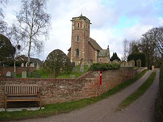
Ainderby Quernhow is a village and civil parish in North Yorkshire, England. The village is situated on the B6267 Thirsk to Masham road just east of the A1(M) and is about five miles west of Thirsk. The population of the civil parish was estimated at 70 in 2014.
Ainderby Miers with Holtby is a civil parish in North Yorkshire, England. The population taken at the 2011 Census was less than 100. Information is now kept with the parish of Hackforth. However, in 2015, North Yorkshire County Council estimated that the population of the parish was 20. The parish is bounded to the east by the A1(M) motorway, and is about 3 miles (5 km) south of Catterick, and 4 miles (6.4 km) north of Bedale. It includes the hamlets of Ainderby Miers and Holtby Grange.

Borrowby is a village and civil parish in the North Yorkshire district of North Yorkshire, England. The village is situated in the North York Moors National Park, inland but near the coast, between Whitby and Saltburn-by-the-Sea. The population of the civil parish was estimated at 50 in 2014. According to the 2001 UK census, Borrowby parish had a population of 56.

Thrintoft is a village and civil parish in the former Hambleton District of North Yorkshire, England. It is situated close to the River Swale, 3 miles (5 km) west of Northallerton.

Melmerby is a village and civil parish in North Yorkshire, England, that lies 3.7 miles (6 km) north of Ripon and 0.6 miles (1 km) west of the A1(M) motorway. The population was 386 in the 2011 census.

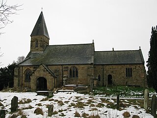
Pickhill is a village in North Yorkshire, England, 6 miles (10 km) west of Thirsk. It is a part of the civil parish of Pickhill with Roxby.

Holme is a small village and civil parish in the Hambleton District of North Yorkshire, England. It is located near Pickhill, Sinderby and Ainderby Quernhow, on the west bank of the River Swale. The population of the civil parish was estimated at 60 in 2014.

Melmerby is a village and civil parish in North Yorkshire, England. It lies in Coverdale in the Yorkshire Dales about 3 miles (4.8 km) south-west of Leyburn. Its neighbours are the villages of Carlton and Agglethorpe. The population of the civil parish was estimated at 40 in 2015.

Wath is a village and civil parish 3.7 miles (6 km) north of Ripon in North Yorkshire, England. The population of the parish was estimated at 210 in 2015.

Healey is a small village and civil parish in the Harrogate district of North Yorkshire, England. It is situated in the valley of the River Burn, to the immediate west of Fearby. It is about three miles west of Masham in the Nidderdale Area of Outstanding Natural Beauty. There are several holiday cottages and four Grade II Listed buildings, one of which is Healey Mill, a former corn mill.

Hanlith is a small village and civil parish in the Craven district of North Yorkshire, England. It is situated near Kirkby Malham and the tourist attraction of Malham Cove. It is about 10 miles (16 km) north west of Skipton, and consists of only 13 houses. Its population was estimated at 40 in 2015.

Warlaby is a small village and civil parish in the Hambleton District of North Yorkshire, England. The population of the civil parish taken at the 2011 Census was less than 100. Details are included in the civil parish of Ainderby Steeple. In 2015, North Yorkshire County Council estimated the population to be around 50 people. It is near the A684 and Morton-on-Swale. It is 1.6 miles (2.5 km) west of Northallerton.
North Otterington is a civil parish with no village centre on the east bank of the River Wiske, in the Hambleton District of North Yorkshire, England. North Yorkshire County Council estimated its population in 2011 to be 40 and 30 in 2015. Details are also included in the civil parish of Ainderby Steeple. It is on the A167 road 3 miles (4.8 km) south of Northallerton; South Otterington is further south on the same road.

Middleton Quernhow is a settlement and civil parish in North Yorkshire, England. The parish is included in the Wathvale Ward with a population of 3,479. North Yorkshire County Council estimated that the population of the parish was 60 in 2015. It is very near the A1(M) road and is 4 miles (7 km) north of Ripon.
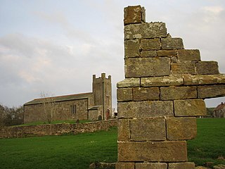
Roxby is a village and civil parish in the Scarborough district of North Yorkshire, England. It is located near Staithes.
Hartwith cum Winsley is a civil parish in former Harrogate district, North Yorkshire, England. Historically it was a township in the ancient parish of Kirkby Malzeard in the West Riding of Yorkshire, a detached part of that parish. It became a separate civil parish in 1866, and was transferred to North Yorkshire in 1974.

Howgrave is a civil parish in the Hambleton District of North Yorkshire, England. It is a very small parish, with an area of only 323 acres (131 ha) and an estimated population in 2014 of only 10. There is no modern village in the parish. The site of the deserted medieval village of Howgrave lies in the west of the parish, 0.3 miles (0.5 km) west of the village of Sutton Howgrave.
Norton Conyers is a civil parish in North Yorkshire, England, 3 miles (5 km) north of Ripon. There is no modern village in the parish. Most of the parish is occupied by the grounds of Norton Conyers House, which cover the site of a deserted medieval village.
Ellerton Abbey is a civil parish in the Richmondshire district of North Yorkshire, England. It is located on the River Swale in lower Swaledale, 6 miles (10 km) south-west of Richmond. The population of the parish was estimated at 20 in 2016. The parish consists of farmland, a few scattered houses and an area of moorland which is part of the army training area associated with Wathgill Camp. The parish includes the site of the deserted medieval village of Ellerton, not to be confused with the modern village of Ellerton-on-Swale 11 miles to the east, but there is no modern village in the civil parish.

Walburn is a hamlet and civil parish in North Yorkshire, England. It is located in lower Swaledale, 5 miles (8 km) south-west of Richmond. The population of the parish was estimated at 10 in 2016.
