
Friedrich Wolfgang Beckey, known as Fred Beckey, was an American rock climber, mountaineer and book author, who in seven decades of climbing achieved hundreds of first ascents of some of the tallest peaks and most important routes throughout Alaska, the Canadian Rockies and the Pacific Northwest. Among the Fifty Classic Climbs of North America, seven were established by Beckey, often climbing with some of the best known climbers of each generation.

Mount Stuart is a mountain in the Cascade Range, in the U.S. state of Washington. It is the second highest non-volcanic peak in the state, after Bonanza Peak and seventh-highest overall. Mount Stuart is the highest peak in the Stuart Range, and it is located in the central part of the Washington Cascades, south of Stevens Pass and east of Snoqualmie Pass in the Alpine Lakes Wilderness.

Mount Hunter or Begguya is a mountain in Denali National Park in Alaska. It is approximately eight miles (13 km) south of Denali, the highest peak in North America. "Begguya" means child in the Dena'ina language. Mount Hunter is the third-highest major peak in the Alaska Range.

Goode Mountain is one of the major peaks of the North Cascades in the U.S. state of Washington. Named for topographer Richard Urquhart Goode of the United States Geological Survey, it is the highest peak located in North Cascades National Park, between the Skagit River and Lake Chelan. It is the fourth-highest non-volcanic peak in Washington, and the twelfth-highest summit overall.

Jack Mountain is the 17th highest mountain in Washington state. It is one of the 10 non-volcanic peaks in Washington State over 9,000 feet (2,700 m). It towers dramatically over the south end of Ross Lake, rising 7,450 ft (2,270 m) above the lakeshore in only 3 horizontal miles (4.8 km). Nohokomeen Glacier nearly fills the cirque on the upper north slopes of the mountain.

Mount Index is a peak in the central part of the Cascade Range of Washington state. It lies just south of the Skykomish River and U.S. Route 2, at the western edge of the Cascades. Despite its low elevation relative to peaks higher in the Cascades, it is a famous and dramatic landmark due to its topographic prominence. It comprises three pointed spires which rise steeply from a very low base. The main peak is the southernmost of the three, while the North Peak rises even more steeply above the valley. For example, it rises more than 4,250 ft (1,300 m) above the lower slopes on the northeast side in less than 1 horizontal mile (1.6 km).
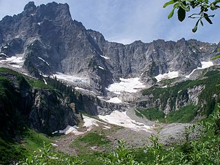
Slesse Mountain, usually referred to as Mount Slesse, is a mountain just north of the US-Canada border, in the Cascade Mountains of British Columbia, near the town of Chilliwack. It is notable for its large, steep local relief. For example, its west face drops over 1,950 m (6,398 ft) to Slesse Creek in less than 3 km (2 mi). It is also famous for its huge Northeast Buttress; see the climbing notes below. The name means "fang" in the Halkomelem language. Notable nearby mountains include Mount Rexford and Canadian Border Peak in British Columbia, and American Border Peak, Mount Shuksan, and Mount Baker, all in the US state of Washington.

Silver Star Mountain is an 8,876-foot (2,705-metre) mountain located in Okanogan County, Washington. The mountain is part of the Methow Mountains, a subset of the Cascade Range. Silver Star is the dominant feature in the Washington Pass area and visible from the North Cascades Highway. It was first climbed by Lage Wernstedt in 1926.

Sahale Mountain is a jagged, glaciated mountain, in North Cascades National Park, in northern Washington state. The summit of Sahale Mountain is referred to as Sahale Peak. It is 0.3 miles (0.48 km) south of its higher neighbor, Boston Peak, and the saddle between the two is 80 feet (24 m) lower than Sahale's summit. Quien Sabe Glacier is to the west of the ridge between the two peaks while Davenport Glacier is in a cirque east of this ridge and above Horseshoe Basin. Sahale Glacier is south of the summit and east of Sahale Arm, a ridge that extends southwest from Sahale to Cascade Pass. The name Sahale may originate from a Northwest Native American word meaning "high place," "falcon," or "sacred."

Eldorado Peak is a 8,868-foot (2,703 m) peak, and is the 25th highest peak in Washington. The mountain is located in the North Cascades of Washington, approximately 27 miles (43 km) east of Concrete. It is located in North Cascades National Park at the head of Marble Creek and just west of the Inspiration Glacier. Other glaciers in the immediate vicinity include Eldorado Glacier and McAllister Glacier; thus Eldorado is flanked by the largest continuous non-volcanic ice sheet in the lower 48 states.

Liberty Bell Mountain is located in the North Cascades, State of Washington, United States, approximately one mile south of Washington Pass on the North Cascades Highway. Liberty Bell is the most northern spire of the Liberty Bell Group, a group of spires that also includes Concord Tower, Lexington Tower, North Early Winters Spire, and South Early Winters Spire.
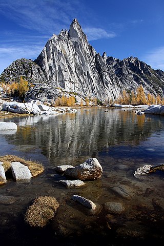
Prusik Peak is an 8,008-foot (2,441-metre) granite summit located at the west end of The Temple in Chelan County of Washington state. Prusik Peak is part of The Enchantments within the Alpine Lakes Wilderness and is often the iconic photographic image of both areas. Prusik Peak belongs to the Stuart Range which is a subset of the Cascade Range. The toponym honors Dr. Karl Prusik (1896–1961) who was an Austrian mountaineer, known as the inventor of the prusik, a rope knot which happened to be used to gain access to the summit horn during the first ascent by Fred Beckey in 1948. Precipitation runoff drains into Icicle Creek which is a tributary of the Wenatchee River.

Dorado Needle is an 8,440+ ft mountain summit located in North Cascades National Park in Skagit County of Washington state. The peak lies 0.73 miles north of Eldorado Peak and 1.33 mi (2.14 km) southeast of Perdition Peak. It can be seen from the North Cascades Highway west of Marblemount at a road pullout along the Skagit River. The first ascent of the peak was made in July 1940 by Lloyd Anderson, Karl Boyer, and Tom Gorton via the Northwest Ridge. Precipitation runoff and glacier meltwater from the mountain drains into tributaries of the Skagit River.

Cathedral Peak is an 8,606-foot (2,623-metre) mountain summit located in Okanogan County in Washington state. It is part of the Okanogan Range which is a sub-range of the North Cascades. The mountain is situated in the Pasayten Wilderness, on land administered by the Okanogan–Wenatchee National Forest. The nearest higher peak is Grimface Mountain, 2.6 miles (4.2 km) to the north in Cathedral Provincial Park in Canada. The Pacific Northwest Trail traverses below the south slope of Cathedral Peak as it crosses Cathedral Pass. Less than a mile to the opposite side of the pass stands Amphitheater Mountain. Precipitation runoff from Cathedral Peak drains west into Cathedral Fork, or east into Cathedral Creek.

Castle Peak is a prominent 8,343-foot (2,543-metre) mountain summit located in the Hozameen Range of the North Cascades, on the shared border between Okanogan County and Whatcom County of Washington state. The mountain is situated one mile (1.6 km) south of the Canada–United States border, on the Cascade crest, in the Pasayten Wilderness, on land managed by the Okanogan–Wenatchee National Forest. The nearest higher peak is Jack Mountain, 14.8 miles (23.8 km) to the south-southwest. Castle Peak is the second highest summit of the Hozameen Range following Jack Mountain. Castle Peak is the sixth-highest mountain in the Pasayten Wilderness. Precipitation runoff from the mountain drains east into Castle Creek, a tributary of the Similkameen River, or west into tributaries of the Skagit River. Topographic relief is significant as the summit rises nearly 3,000 feet above Crow Creek in 0.75 mile (1.2 km).

Alpaca Peak is a 2,083-metre (6,834-foot) granitic mountain located in the North Cascades of southwestern British Columbia, Canada. It is situated 8 km (5 mi) northwest of Coquihalla Summit, and 1.47 km (1 mi) southwest of Vicuna Peak, its nearest higher peak. Precipitation runoff from the peak drains west into headwaters of the East Anderson River, or east into headwaters of the Coldwater River. The mountain was named for the alpaca, as part of the ungulate names theme for several other nearby peaks that were submitted by Philip Kubik of the 1965 first ascent party. The mountain's name was officially adopted on March 23, 1976, by the Geographical Names Board of Canada.
Gemse Peak, is a 1,890-metre (6,200-foot) granitic horn located in the North Cascades of southwestern British Columbia, Canada. It is situated 12 km (7 mi) west-northwest of Coquihalla Summit, 3.5 km (2 mi) west of Alpaca Peak, and 2.5 km (2 mi) northeast of Steinbok Peak. Precipitation runoff from the peak drains into tributaries of the Anderson River. The mountain was named for the gemse, the chamois of Germany, as part of the ungulate names theme for several other nearby peaks that were submitted by Philip Kubik of the 1974 first ascent party. The mountain's name was officially adopted on February 5, 1976, by the Geographical Names Board of Canada.
Ingalls Peak is a 7,662-foot (2,335-metre) triple-summit mountain located in the Alpine Lakes Wilderness, along the common border of Kittitas County and Chelan County, in Washington state. Ingalls Peak is the highest point in the Teanaway area of the Wenatchee Mountains. It is situated 2 mi (3.2 km) west of Mount Stuart, and immediately west of Lake Ingalls, on land managed by Wenatchee National Forest. Its subpeaks are the South Peak and the East Peak. Precipitation runoff from the peak drains north into Jack Creek, a tributary of Icicle Creek; west into Fortune Creek; or east into Ingalls Creek, a tributary of the Wenatchee River. This peak, the lake, creek, and pass are named for Captain Benjamin Ingalls of the United States Cavalry who led an 1855 survey of this area and is credited with discovering gold in the region.

White Goat Mountain is a 7,800+ ft mountain summit located in the Glacier Peak Wilderness of the North Cascades in Washington state. The mountain is situated in Chelan County, on land managed by Wenatchee National Forest. Its nearest higher neighbor is Tupshin Peak, 0.7 mi (1.1 km) to the northeast, and Devore Peak is 1.02 mi (1.64 km) to the south. Precipitation runoff from the peak drains to nearby Lake Chelan via Company and Devore Creeks. The first ascent was made September 10, 1940, by Everett and Ida Zacher Darr, Joe Leuthold, and Eldon Metzger. A herd of mountain goats beneath the peak was their inspiration for so naming this geographical feature.

Edward Peak, also known as The Mole, is a 7,280-foot (2,219-metre) granite summit located in Chelan County of Washington state. It is set within the Alpine Lakes Wilderness, on land managed by Okanogan-Wenatchee National Forest. Edward Peak belongs to the Stuart Range which is a subset of the Cascade Range. It is situated 1.9 miles (3.1 km) north of The Temple, and the nearest town is Leavenworth, 7 miles (11 km) to the northeast. Precipitation runoff from the mountain drains north into Icicle Creek via Rat Creek.


