
North Petherton is a small town and civil parish in Somerset, England, situated on the edge of the eastern foothills of the Quantocks, and close to the edge of the Somerset Levels. The town has a population of 6,730. The parish includes Hamp, Melcombe, Woolmersdon and Huntworth.
Durston is a village and civil parish in Somerset, England, situated on the A361 road 5 miles (8.0 km) north east of Taunton and 6 miles (9.7 km) south of Bridgwater in the Somerset West and Taunton district. The parish lies on undulating ground between the lowest slopes of the Quantock Hills and the valley of the River Tone at the Curry and Hay Moors. The village has a population of 136.
A rhyne (Somerset), rhine/rhyne (Gloucestershire), or reen is a drainage ditch, or canal, used to turn areas of wetland at around sea level into useful pasture.
Chedzoy is a civil parish village 3 miles (4.8 km) east of Bridgwater in the Sedgemoor district of Somerset.

Goathurst is a small village and civil parish in the English county of Somerset, around 3 miles from the town of Bridgwater. The parish includes the hamlets of Andersfield and Huntstile. The village is on the route of the Samaritans Way South West.

Spaxton is a small village and civil parish on the Quantocks in the Sedgemoor district of Somerset, South West England.

Durleigh is a village and civil parish on the outskirts of Bridgwater in the Sedgemoor district of Somerset, England. According to the 2011 Census, it had a population of 548. Its nearest town is Bridgwater, which lies approximately 1.6 miles (2.6 km) north-east from the village.

The Church of St Mary is the parish church of Cannington, Somerset, England.
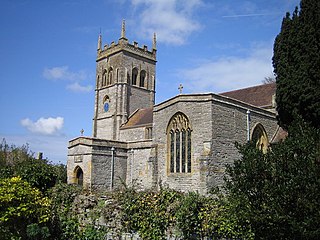
The Church of St Margaret in Spaxton, Somerset, England has some parts from the 12th and 13th centuries but is predominantly from the 15th century, and was restored in 1895. It has been designated as a Grade I listed building.
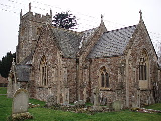
The Church of St Mary in North Petherton, Somerset, England dates from the 15th century and has been designated as a grade I listed building. It is on the Heritage at Risk Register due to the condition of the roof and north aisle parapet.

The Corn Exchange and market house in Bridgwater, Somerset, England was built in 1834 by John Bowen and extended in 1875, by Charles Knowles. It has been designated as a Grade I listed building.

The Hundred of North Petherton is one of the 40 historical Hundreds in the ceremonial county of Somerset, England, dating from before the Norman conquest. Although the Hundreds have never been formally abolished, their functions ended with the establishment of county courts in 1867 and the introduction of districts by the Local Government Act 1894. The name of the hundred derives from the name of the large royal estate that covered much of the area in 1086, recorded variously as Nortpetret in the Domesday Book, Nortpedret in Liber Exoniensis and Nort Peretu in the associated tax returns. This, in turn, was derived from the area's location to the northern end of the River Parrett.
The Hundred of South Petherton is one of the 40 historical Hundreds in the ceremonial county of Somerset, England, dating from before the Norman conquest during the Anglo-Saxon era although exact dates are unknown. Each hundred had a 'fyrd', which acted as the local defence force and a court which was responsible for the maintenance of the frankpledge system. They also formed a unit for the collection of taxes. The role of the hundred court was described in the Dooms (laws) of King Edgar. The name of the hundred was normally that of its meeting-place.
The Hundred of Martock is one of the 40 historical Hundreds in the ceremonial county of Somerset, England, dating from before the Norman conquest during the Anglo-Saxon era although exact dates are unknown. Each hundred had a 'fyrd', which acted as the local defence force and a court which was responsible for the maintenance of the frankpledge system. They also formed a unit for the collection of taxes. The role of the hundred court was described in the Dooms (laws) of King Edgar. The name of the hundred was normally that of its meeting-place.
Alfred of Spain was a Norman lord recorded in the Domesday Book. He held land mainly in Somerset but also in Devon, Dorset, Wiltshire, Gloucestershire and Herefordshire. He was not from Spain but from Épaignes in Normandy. The Domesday scribes rendered his name into Latin as Alvredi De Ispania as a kind of word play and in English his name is written variously Alfred or Alvredof or de Spain, Hispania or Ispania. It has been suggested that he may have built the castle at Nether Stowey or possibly an earlier one which has disappeared at Over Stowey. Much of his land was the pre-conquest estate of a Saxon lord Alfwy although the important manor of Stowey had been held by King Harold.

Walford is a small village 3 miles (5 km) north east of Taunton in Somerset, England. Most of the village, including Walford Cross at the junction of the A38 and the A361, lies in the civil parish of Creech St Michael. The western part of the village, including Walford House, is in the civil parish of West Monkton. The village lies close to the A38 and the M5 motorway.

Petherton Park was a Deer park around North Petherton within the English county of Somerset.
The Manor of Sydenham was a historic manor in Somerset, England, situated about 1/4 mile north-east of the centre of historic Bridgwater. Sydenham House, the manor house, a grade II listed building situated in the parish of Wembdon, was built in the early 16th century and refronted and rebuilt after 1613. In 1937 British Cellophane Ltd set up production and built extensive factories on 59 acres of land adjacent to the manor house. Production ceased in 2005 and between 2010 and 2015 the industrial site was razed to the ground. In 2015 the razed site is owned by EDF Energy, which in 2012 purchased the manor house with the former factory site, intended for construction of temporary accommodation for 1,000 workers on the proposed new Hinkley Point C nuclear power station 12 miles away. The Manor House is situated to the north side of the A39 Bath Road. Its owners were on the losing side in the Civil War and again in the Monmouth Rebellion.

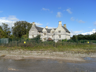
West Bower Manor in Durleigh within the English county of Somerset was largely built in the 15th century. It is a Grade II* listed building.

The Anglican Church of St Peter in North Newton within the English county of Somerset has a tower believed to date from Saxon times. It is a Grade II* listed building.
