Hundred of North Petherton

Last updated
North Petherton
Andersfield Hundred.png
Map including the Hundred of North Petherton
Area
23,150 acres (9,370 ha) excluding Bridgwater
History
  Createdunknown; before 1066
Status Hundred
   HQ North Petherton
Subdivisions
  TypeTown, parishes
  Units Bridgwater, Bawdrip, Chedzoy, Chilton Trinity, Durston, St Michael Church, Pawlett, North Petherton, Thurloxton, Wembdon

The Hundred of North Petherton is one of the 40 historical Hundreds in the ceremonial county of Somerset, England, dating from before the Norman conquest. Although the Hundreds have never been formally abolished, their functions ended with the establishment of county courts in 1867 [1] and the introduction of districts by the Local Government Act 1894. [2] The name of the hundred derives from the name of the large royal estate (later expanded by Henry II to become the Royal Forest of North Petherton [3] ) that covered much of the area in 1086, recorded variously as Nortpetret in the Domesday Book, Nortpedret in Liber Exoniensis and Nort Peretu in the associated tax returns. [4] This, in turn, was derived from the area's location to the northern end of the River Parrett.

Contents

The hundred was administered from North Petherton, which had been the hundred meeting place and at the centre of the royal estate during Saxon times. [3]

11th century

A large royal estate existed at North Petherton in 1084 and constituted a hundred; assessed at 38 hides, 3 virgates, and ½ ferling. [5] At the time of the Norman invasion the hundred covered a large area corresponding, today, roughly to a north–south corridor along the M5 motorway from Junction 25 near Taunton, to north of Junction 23 at Stretcholt, and east–west from Athelney to Goathurst. According to the Domesday Book it included the 37 places in the table below. [6] Although the settlement of North Petherton had what was then considered to be a very large population, [7] it paid little tax as much of it, including the Manor of North Petherton, was held by the king. [8] [9] The Manor and hundred were granted at fee farm by Henry I to John of Erleigh (d. circa 1162). The North Petherton hundred, the former royal estate, was held by the family of John of Erleigh as was the manor of North Petherton until 1371 when his descendant another John of Erleigh was licensed to alienate the hundred and manor to John and Margery Cole. [5]

PlaceTax paid (geld units)Number of households
(North) Petherton 0.865
(West) Monkton 1556
Newton (West Newton and North Newton)438
Creech (St Michael) 10.536
Bridgwater 532
Bawdrip 227
Bower (East Bower and West Bower)1.323
Adsborough 221
Horsey 219
Woolmersdon 0.918
Durston 2.817
Perry 3.217
Lyng 113
Hadworthy 112
Hamp 112
Wembdon 212
Melcombe 0.410
Clayhill 19
Huntworth 19
Sandford 1.29
Stretcholt 19
Bradney 18
Shearston 0.58
Huntstile 0.37
Pawlett 0.36
Pignes 1.36
Waldron 16
Crandon 0.55
Crook 0.34
Walpole 0.84
Chilton (Trinity) 0.53
Rime 0.11
Athelney 00
Dunwear 0.30
Shovel 0.30
St Michael Church 0.50
Sydenham 0.30

13th & 14th century

By 1285 the Hundred of North Petherton is known to have included the villages and hamlets of North Petherton, West Newton, Bawdrip, Horsey, Woolmersdon, Durston, Perry, Wembdon, Clayhill, Huntworth, Sandford, East and West Stretcholt, Shearston, Pawlett, Pignes, Crandon, Chilton, Dunwear and Sydenham – all of which had been included at the time of the Domesday Book – together with Chedzoy, Tuckerton and Thurloxton which had not received separate mentions in Domesday; by 1303 Ford, Wood and Kidsbury were also named separately within the hundred. [8]

The status of various places also changed over the intervening years. Although Lyng and Bridgwater had been included in the hundred at the time of Domesday, by 1275 Lyng held the status of a free manor and Bridgwater borough was described as a separate hundred; however by 1316 they had both returned to the jurisdiction of the Hundred of North Petherton. [8]

16th century

In addition to changes in status, some places also moved to other hundreds. Having been part of the Hundred of North Petherton at the time of Domesday, after a period of as a free manor Creech St Michael became part of Andersfield Hundred in 1569, while Lyng is also listed in Andersfield Hundred in 1640. [10] At some point Sydenham also left North Petherton Hundred and became part of Andersfield Hundred, before leaving it again in 1652. [10]

19th century

By 1868 the town of Bridgwater and the parishes of Bawdrip, Chedzoy, Chilton Trinity, Durston, St. Michael Church, Pawlett, North Petherton, Thurloxton, and part of Wembdon were within the Hundred of North Petherton, which (excluding Bridgwater) covered an area of 23,150 acres (94 square kilometres). [11] Part of the Parish of North Petherton, a separate tithing known in 1841 as Petherton limit which may have dated from the 1670s, lay within the Hundred of Andersfield. [12] The Hundreds of Cannington and Taunton Dean lay to the West, Andersfield to south and west, with Huntspill and Puriton to the north east and Whitley Hundred and North Curry Hundred to the east, separated by the River Parrett. [13] [14] [15]

The 1851 Parliamentary gazetteer of England and Wales stated that the hundred had 1,047 houses and a population of 5,800 in 1831. [13] By 1887 the Gazetteer of the British Isles showed that the population had increased to 7,476. [16]

Parish boundaries

At least in later centuries, and possibly earlier than 1086, civil parish boundaries were not necessarily constrained by the boundaries of the hundred, and could extend into more than one hundred. The civil parish of Huntstile, for example, was partly in North Petherton Hundred and partly in Andersfield Hundred. [4]

Related Research Articles

Chedzoy Human settlement in England

Chedzoy is a civil parish village 3 miles (4.8 km) east of Bridgwater in the Sedgemoor district of Somerset.

Spaxton Human settlement in England

Spaxton is a small village and civil parish on the Quantocks in the Sedgemoor district of Somerset, South West England.

Church of St Mary & All Saints, Broomfield

The Church of St Mary & All Saints in Broomfield, Somerset, England was built in the 15th and 16th centuries and has been designated as a Grade I listed building.

St Marys Church, Cannington

The Church of St Mary is the parish church of Cannington, Somerset, England. The parish is in the Church of England Diocese of Bath and Wells.

St Margarets Church, Spaxton

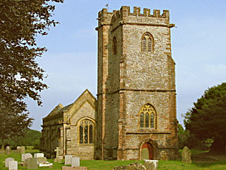
The Church of St Margaret in Spaxton, Somerset, England has some parts from the 12th and 13th centuries but is predominantly from the 15th century, and was restored in 1895. It has been designated as a Grade I listed building.

Church of St Mary, North Petherton

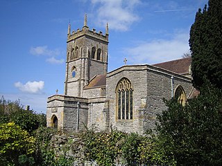
The Church of St Mary in North Petherton, Somerset, England dates from the 15th century and has been designated as a grade I listed building. It is on the Heritage at Risk Register due to the condition of the roof and north aisle parapet.

Corn Exchange, Bridgwater

The Corn Exchange and market house in Bridgwater, Somerset, England was built in 1834 by John Bowen and extended in 1875, by Charles Knowles. It has been designated as a Grade I listed building.

Gothelney Hall

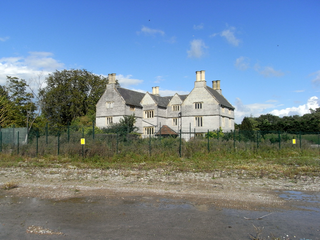
Gothelney Hall, also known as Gothelney Manor Farmhouse, located in the parish of Spaxton, Somerset, England was built in the 15th century and has been designated as a Grade I listed building.

Buckland Priory

Buckland Priory was established around 1167 in Lower Durston, Somerset, England.

Hundred of Andersfield

The Hundred of Andersfield is one of the 40 historical Hundreds in the ceremonial county of Somerset, England, dating from before the Norman conquest during the Anglo-Saxon era although exact dates are unknown.

The Somerset Victoria County History is an encyclopaedic history of the county of Somerset in England, forming part of the overall Victoria County History of England founded in 1899 in honour of Queen Victoria. With ten volumes published in the series A History of the County of Somerset, the Somerset VCH is among the most substantial of the Victoria County Histories.

Alfred of Spain was a Norman lord recorded in the Domesday Book. He held land mainly in Somerset but also in Devon, Dorset, Wiltshire, Gloucestershire and Herefordshire. He was not from Spain but from Épaignes in Normandy. The Domesday scribes rendered his name into Latin as Alvredi De Ispania as a kind of word play and in English his name is written variously Alfred or Alvredof or de Spain, Hispania or Ispania. It has been suggested that he may have built the castle at Nether Stowey or possibly an earlier one which has disappeared at Over Stowey. Much of his land was the pre-conquest estate of a Saxon lord Alfwy although the important manor of Stowey had been held by King Harold.

Church of St Peter and St Paul, Over Stowey

Church Of St Peter And St Paul in Over Stowey, Somerset, England is the Anglican parish church for the ancient parish of Over Stowey, now part of the Quantock Villages Benefice in the Diocese of Bath and Wells.

Walford, Somerset Human settlement in England

Walford is a small village 3 miles (5 km) north east of Taunton in Somerset, England. Most of the village, including Walford Cross at the junction of the A38 and the A361, lies in the civil parish of Creech St Michael. The western part of the village, including Walford House, is in the civil parish of West Monkton. The village lies close to the A38 and the M5 motorway.

Petherton Park

Petherton Park was a Deer park around North Petherton within the English county of Somerset.

Sydenham House, Somerset

Sydenham House, the manor house of the ancient manor of Sydenham in the parish of Wembdon, Somerset, England, is a grade II listed building, constructed in the early 16th century and refronted and rebuilt after 1613. In 1937, British Cellophane Ltd set up production and built extensive factories on 59 acres (24 ha) of land adjacent to the manor house. Production ceased in 2005 and between 2010 and 2015 the industrial site was razed to the ground. In 2015 the razed site is owned by EDF Energy, which in 2012 purchased the manor house with the former factory site, intended for construction of temporary accommodation for 1,000 workers.

Church of St Giles, Thurloxton

The Norman Anglican Church of St Giles in Thurloxton dates from the 14th century but is predominantly from the 15th century with 19th-century restoration including the addition of the north aisle in 1868. It has been designated by English Heritage as a Grade II* listed building.

West Bower Manor

West Bower Manor in Durleigh within the English county of Somerset was largely built in the 15th century. It is a Grade II* listed building.

Church of St Hugh, Durleigh

The Church of St Hugh at Durleigh in the English county of Somerset was built in the 11th century. It is a Grade II* listed building.

Church of St Peter, North Newton

The Anglican Church of St Peter in North Newton within the English county of Somerset has a tower believed to date from Saxon times. It is a Grade II* listed building.

References

  1. County Courts Act 1867 (30 & 31 Vict. c. 142) s.28
  2. Mapping the Hundreds of England and Wales in GIS University of Cambridge Department of Geography, published 06-06-08, accessed 2011-10-12
  3. 1 2 Gathercole, Clare. "North Petherton" (PDF). The Somerset Urban Archaeological Survey. Somerset County Council. Archived from the original (PDF) on 7 August 2011. Retrieved 23 May 2010.
  4. 1 2 Somerset Introduction v1a, Caroline Thorn & Frank Thorn, Published February, April 2007, accessed 2011-10-17 (cache of original document)
  5. 1 2 "North Petherton Hundred – A History of the County of Somerset: Volume 6". pp. 178–181. Retrieved 2012-07-07.
  6. Hundred: North Petherton Open Domesday, accessed 2011-10-12
  7. Place: North Petherton Archived 2012-07-28 at archive.today Open Domesday
  8. 1 2 3 R W Dunning, C R Elrington (Editors), A P Baggs, M C Siraut (1992). "North Petherton Hundred". A History of the County of Somerset: Volume 6: Andersfield, Cannington, and North Petherton Hundreds (Bridgwater and neighbouring parishes). Institute of Historical Research. Retrieved 17 October 2011.CS1 maint: multiple names: authors list (link)
  9. R W Dunning, C R Elrington (Editors), A P Baggs, M C Siraut (1992). "North Petherton: Manors and other estates". A History of the County of Somerset: Volume 6: Andersfield, Cannington, and North Petherton Hundreds (Bridgwater and neighbouring parishes). Institute of Historical Research. Retrieved 13 October 2011.CS1 maint: multiple names: authors list (link)
  10. 1 2 R W Dunning, C R Elrington (Editors), A P Baggs, M C Siraut (1992). "Andersfield Hundred". A History of the County of Somerset: Volume 6: Andersfield, Cannington, and North Petherton Hundreds (Bridgwater and neighbouring parishes). Institute of Historical Research. Retrieved 15 October 2011.CS1 maint: multiple names: authors list (link)
  11. Somerset National Gazetteer (1868), published 1968
  12. R W Dunning, C R Elrington (Editors), A P Baggs, M C Siraut (1992). "North Petherton: Local government". A History of the County of Somerset: Volume 6: Andersfield, Cannington, and North Petherton Hundreds (Bridgwater and neighbouring parishes). Institute of Historical Research. Retrieved 13 October 2011.CS1 maint: multiple names: authors list (link)
  13. 1 2 The Parliamentary gazetteer of England and Wales, Volume III, published 1851
  14. The Parliamentary gazetteer of England and Wales, Volume IV, published 1851
  15. http://www.british-history.ac.uk/image.aspx?compid=18631&filename=fig25.gif&pubid=69 Map of North Petherton Hundred, circa 1840], accessed 2011-10-17]
  16. A Vision Britain Through Time Gazetteer of the British Isles (1887), John Bartholomew, published 1887, accessed 2011-10-13