Related Research Articles
West Somerset was a local government district in the English county of Somerset from 1974 to 2019. The council covered a largely rural area, with a population of 34,900 in an area of 740 square kilometres (290 sq mi); it was the least populous non-unitary district in England. According to figures released by the Office for National Statistics in 2009, the population of West Somerset had the oldest average age in the United Kingdom at 52. The largest centres of population were the coastal towns of Minehead and Watchet (4,400).

Dulverton is a town and civil parish in west Somerset, England, near the border with Devon. The town had a population of 1,408 at the 2011 Census. The parish includes the hamlets of Battleton and Ashwick which is located approximately 4 miles (6.4 km) north west of Dulverton.
Williton is a large village and civil parish in Somerset, England, at the junction of the A39, A358 and B3191 roads, on the coast 2 miles (3.2 km) south of Watchet between Minehead, Bridgwater and Taunton in the now-defunct Somerset West and Taunton district.

Brompton Ralph is a village and civil parish in the Somerset West and Taunton district of Somerset, England, about 11 miles (18 km) west of Taunton, and 3 miles (5 km) north of Wiveliscombe. It is in a wooded district at the eastern extremity of the Brendon Hills. According to the 2002 population estimates it had a population of 287.

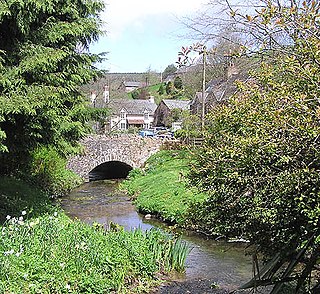
Brompton Regis is a village and civil parish in the Somerset West and Taunton district of Somerset, England about 5 miles (8.0 km) north-east of Dulverton. It is situated on the River Pulham in the Brendon Hills within the Exmoor National Park, close to Wimbleball Lake, a water supply reservoir constructed in the 1970s and completed in 1979. According to the 2011 census the village had a population of 449. The parish boundary is marked by the River Exe which is crossed by the medieval Chilly Bridge and Hele Bridge. The Haddeo is crossed by Bury Bridge.

Brushford is a village and civil parish 2 miles (3.2 km) south of Dulverton and 12 miles (19 km) north of Tiverton in Devon, in the Somerset West and Taunton district of Somerset, England. According to the 2001 census, it had a population of 535 in 243 households, reducing to 519 at the 2011 Census. It covers an area of 1,149 hectares (11 km2) of which 3 hectares (0.030 km2) is within the Exmoor National Park.

Decuman was one of the Celtic saints who came to Somerset from Pembrokeshire, South Wales, in the seventh century, arriving on a raft with a cow for a companion. There he was a pastor and physician to the local inhabitants.

West Quantoxhead (St Audries) is a small village and civil parish in the Somerset West and Taunton district of Somerset, England. It lies on the route of the Coleridge Way and on the A39 road at the foot of the Quantock Hills, 3 miles (5 km) from East Quantoxhead, 2.5 miles (4 km) from Williton and equidistant from Bridgwater and Taunton. The parish includes the hamlets of Weacombe and Lower Weacombe.

Upton is a village and civil parish north of Skilgate in Somerset, England. It is situated on a hill above the eastern end of Wimbleball Lake.
Luxborough is a small village and civil parish located some 6 miles (9.7 km) south of Dunster, lying amongst the Brendon Hills and the Exmoor National Park in Somerset, England. It is divided into the hamlets of Churchtown, Kingsbridge and Pooltown, which lie within a mile of each other. Luxborough, 'Lolochesberie' in the Domesday Book, means 'stronghold or hill of a man called Lulluc'.

Old Cleeve is a village 5 miles (8 km) south east of Minehead in the Somerset West and Taunton district of Somerset, England, and also a civil parish. The civil parish of Old Cleeve covers an area of 2,092 hectares and includes the villages of Old Cleeve, Roadwater and Washford as well as hamlets such as Bilbrook, Chapel Cleeve, Golsoncott and Leighland Chapel. Approximately half the parish lies within the Exmoor National Park. The remaining half is on the southern edge of Exmoor. The village has been in existence since the early 13th century. The village held its first council meeting in 1711. By the 1720s the parish had several churches, in which to meet. The town hall was built in 1727. The first church here was built in 1694, built by the Eastern Christian Society. This church was destroyed in a fire in 1847, and has been rebuilt and restored. In 2011, the population of the parish was 1,672.

Winsford is a village and civil parish in Somerset, England, located about 5 miles (8 km) north-west of Dulverton.

Huish Champflower is a village and civil parish in Somerset, England, three miles north-west of Wiveliscombe and ten miles north of Wellington. It has a population of 301.
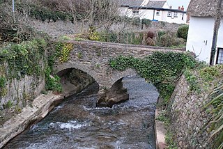
The Washford River is a river in the English county of Somerset. It rises at 600 feet (183 m) above mean sea level near the village of Treborough, in the Brendon Hills, and flows into the Bristol Channel in the port town of Watchet. On its course it flows through the civil parishes of Treborough, Luxborough, Withycombe, Old Cleeve, Nettlecombe, Williton and Watchet, and through the settlements of Pooltown, Kingsbridge, Roadwater, Torre, Washford and Watchet.

East Quantoxhead is a village in the district of Somerset West and Taunton, 3 miles (5 km) from West Quantoxhead, 4 miles (6 km) east of Williton, and 13 miles (21 km) west of Bridgwater, within the Quantock Hills Area of Outstanding Natural Beauty in Somerset, England.
Elworthy is a small village and civil parish in the Brendon Hills 5 miles (8 km) south-east of Watchet, and 12 miles (19 km) west of Taunton, in the Somerset West and Taunton district of Somerset, England. The parish includes the hamlet of Willett.

Skilgate is a village and civil parish 5 miles (8 km) east of Dulverton and 8 miles (13 km) west of Wiveliscombe in the Somerset West and Taunton district of Somerset, England. It has a population of 96.

Treborough is a small village and civil parish 7 miles (11 km) south of Dunster, lying amongst the Brendon Hills within the Exmoor National Park in the Somerset West and Taunton district of Somerset, England.
Williton was a rural district in Somerset, England, from 1894 to 1974.
The Somerset Victoria County History is an encyclopaedic history of the county of Somerset in England, forming part of the overall Victoria County History of England founded in 1899 in honour of Queen Victoria. With ten volumes published in the series A History of the County of Somerset, the Somerset VCH is among the most substantial of the Victoria County Histories.
References
- ↑ "Williton and Freemanors Hundred". A vision of Britain through time. University of Portsmouth. Retrieved 23 October 2011.
- ↑ "Administrative Units Typology | Status definition: Hundred". Vision of Britain. Retrieved 18 October 2011.
- ↑ "The Shire and the Hundred". Somerset County Council. Archived from the original on 14 August 2011. Retrieved 13 October 2011.
- ↑ "Summary". Institute of Archaeology. Archived from the original on 25 May 2010. Retrieved 15 October 2011.
- ↑ "Somerset Hundreds". GENUKI. Retrieved 23 October 2011.
- ↑ "Somerset". University of Hull. Archived from the original on 10 July 2012. Retrieved 23 October 2011.
- ↑ County Courts Act 1867 (30 & 31 Vict. c. 142) s.28
- ↑ "Mapping the Hundreds of England and Wales in GIS". University of Cambridge Department of Geography. 6 June 2008. Retrieved 15 October 2011.