Huning Highlands

Last updated
Huning Highlands
Neighborhood of Albuquerque
20160318172037599851000000-o(1).jpg
The Seth House
Coordinates: 35°04′59″N106°38′28″W / 35.083°N 106.641°W / 35.083; -106.641 Coordinates: 35°04′59″N106°38′28″W / 35.083°N 106.641°W / 35.083; -106.641
Government
[1]
  City CouncilIsaac Benton
   State House Gail Chasey (D)
Javier Martínez (D)
   State Senate Jerry Ortiz y Pino (D)
   U.S. House Deb Haaland (D)
Area
  Total0.21 sq mi (0.5 km2)
Population
 (2010) [2]
  Total1,047
  Density5,038/sq mi (1,945/km2)
ZIP Code
87102 [1]
Area code(s) 505

Huning Highlands, also known as EDo or East Downtown, is an inner-city neighborhood in Albuquerque, New Mexico, directly east of Downtown. It is a mostly residential area known for its high concentration of Victorian and early 20th-century houses and is listed on the National Register of Historic Places as the Huning Highlands Historic District. There is also a commercial district along the main thoroughfares, Central Avenue (former U.S. Route 66) and Broadway Boulevard. Huning Highlands was developed starting in 1880 and is named for Franz Huning, a prominent businessman at the time.

Contents

Geography

The generally accepted boundaries of the neighborhood are Dr. Martin Luther King Jr. Avenue to the north, Locust Street to the east, Coal Avenue to the south, and the Burlington Northern Santa Fe railroad tracks to the west. [3] [4] The historic district boundaries extend an additional block south to Iron Avenue. [5] Adjacent neighborhoods include Downtown to the west, Martineztown-Santa Barbara to the north, Sycamore to the east, and South Broadway to the south. The terrain consists of rising sand hills which increase in elevation from west to east.

Demographics

The 2010 United States Census recorded a population in Huning Highlands of approximately 1,047 residents. The racial breakdown of the neighborhood was 51% non-Hispanic white, 37% Hispanic, 4% American Indian, 3% Asian, 2% Black, and 3% other races or mixed-race. [2]

History

The Atchison, Topeka, and Santa Fe Railway reached Albuquerque in 1880, fueling land speculation as investors hoped to profit from its arrival. The New Mexico Town Company, formed by local businessmen Franz Huning, Elias S. Stover, and William Hazeldine, succeeded in attracting the railroad facilities to their chosen site about 1.5 miles (2.4 km) from the existing community at Old Town. The 3.1-square-mile (8.0 km2) parcel they assembled quickly developed into the booming community of New Town—today's Downtown. [6] Huning also owned land in the rolling sandhills further to the east, which was known as the Highlands due to its elevation. In 1880, the land was platted as the first subdivision to be added to the original townsite. This new neighborhood was named Huning's Highland Addition, which later shifted to Huning Highlands. [3]

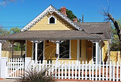
The neighborhood was laid out by civil engineer Walter G. Marmon, who named the main north-south streets Arno, after Franz Huning's son, Walter and Edith after his own son and daughter, and Broadway, because "every town should have a Broadway". [3] The uppermost street of the gently sloping neighborhood was named High Street. The Highlands quickly became one of Albuquerque's most popular residential areas and was home to many of the city's prominent early residents. Unlike the old Hispanic neighborhoods like Old Town, Barelas, and Atrisco, Huning Highlands was primarily built by recently arrived Anglo-Americans and European immigrants. As such, the houses in the neighborhood reflected styles and materials popular in the eastern and Midwestern United States—Queen Anne, Italianate, and other Victorian styles—rather than traditional regional forms. Most of the houses were built using prefabricated trim and architectural elements in a mix-and-match approach not adhering to any particular style, though some are more cohesive. [3]

The neighborhood continued to fill in between the 1880s and 1920s, by which time it was almost completely built up. [3] Residents enjoyed amenities like Highland Park, one of the city's oldest public parks, the Old Main Library, and an electric streetcar line which went into service in 1911. [7] However, as the city continued to grow, many wealthy residents abandoned the older inner-city neighborhoods in favor of the more suburban developments further to the east. By the 1970s, Huning Highlands had become a relatively poor neighborhood consisting largely of absentee-owned rental housing. [5]

The Huning Highlands Historic District was added to the National Register of Historic Places in 1978 and in 1980, the Albuquerque City Council approved the city's first Historic Overlay Zone for the neighborhood. [8] The city designation requires approval from the Landmarks and Urban Conservation Commission for any alterations to contributing properties in the district and provides tax incentives for home restoration projects. [9] These actions had a positive effect on the neighborhood and led to many of the historic houses being restored. According to the Huning Highlands Historic District Association, the percentage of properties that were considered "blighted or substandard" decreased from 52% in 1976 to 17% in 1986 and was estimated at less than 5% by 2005. [10] Development in the neighborhood's commercial district has also increased since the early 2000s, with large projects including the Albuquerque High Lofts and Innovate ABQ, a mixed-use tech campus. [11]

Education

Huning Highlands is served by Albuquerque Public Schools. Public school students from the neighborhood attend Longfellow or Eugene Field Elementary School, Jefferson Middle School, and Albuquerque High School. [12]

Transportation

The main east-west streets in Huning Highlands are Dr. Martin Luther King Jr. Boulevard, Central Avenue, and Lead and Coal Avenues, a pair of one-way arterials. The major north-south street is Broadway Boulevard. The neighborhood also has access to Interstate 25 immediately to the east.

Huning Highlands is served by the Albuquerque Rapid Transit Red and Green rapid bus lines via the EDo station. Local (non-express) bus service also operates on the following routes: 12 Constitution Commuter, 50 Airport-Downtown, and 92 Taylor Ranch Express on Martin Luther King; 66 Central on Central; 97 Zuni and 217 Downtown-KAFB Limited on Lead/Coal; and 16 Broadway-University-Gibson on Broadway. [13] The major transit hub at Alvarado Transportation Center is just outside the neighborhood to the west.

Places of interest

In addition to the National Register historic district, the neighborhood also includes one individually-listed NRHP property:

There are also five properties that have been designated Albuquerque Historic Landmarks:

Related Research Articles

Hollywood Boulevard Street in Hollywood, Los Angeles, California, United States

Hollywood Boulevard is a major east–west street in Los Angeles, California. It begins in the east at Sunset Boulevard in the Los Feliz district. It proceeds due west as a major thoroughfare through Little Armenia and Thai Town, Hollywood, and West Hollywood. After crossing Laurel Canyon Boulevard, it then runs west as a winding residential street in the hills and canyons in the Hollywood Hills West district. Parts of the boulevard are popular tourist destinations, primarily the fifteen blocks between Gower Street west to La Brea Avenue where the Hollywood Walk of Fame is primarily located.

Old Albuquerque High School High School in Albuquerque, New Mexico

The Old Albuquerque High School is the historic former campus of Albuquerque High School in Albuquerque, New Mexico. It is located in the Huning Highlands neighborhood and is protected by the city as a historic landmark. It is located on the northeast corner of Central and Broadway NE, at the center of an area that has become known as East Downtown or EDo. The campus comprises five buildings, the oldest of which was built in 1914. After the school moved to a new location in 1974, the old buildings were left abandoned for decades before being renovated as loft apartments in the early 21st century. Old Albuquerque High was added to the New Mexico State Register of Cultural Properties in 1977.

Downtown Albuquerque Neighborhood of Albuquerque

Downtown Albuquerque is the central business district of Albuquerque, New Mexico. It is where a significant number of the city's highrise buildings are located, and is the center of government and business for the Greater Albuquerque metropolitan region.

Highland, Denver

Highland is a distinct city-center neighborhood in Denver, Colorado, bounded by West 38th Avenue to the north, a Union Pacific Railroad line on the east, the South Platte River to the southeast, Speer Boulevard on the south, and Federal Boulevard on the west. The Highlands is sometimes used to refer to two separate city-center neighborhoods in Denver; Highland and West Highland, although the two neighborhoods are distinct. Highland and West Highland are both in the area that is referred to as the Northside. Highland is located immediately northwest of downtown. Note that the Highland neighborhood association has a slightly different definition with the easternmost boundary stopping at I-25. And the West Highland neighborhood to the immediate west of Highland, with the borders of 38th and 29th Avenues on the north and south and Federal and Sheridan Boulevards on the east and west. To distinguish between its immediately adjacent neighbor, West Highland, Highland is sometimes referred to as East Highland, Lower Highland or LoHi. The two together are casually called "the Highlands," a term which often falsely encompasses other Northwest Denver neighborhoods such as Jefferson Park, Sunnyside and Berkeley. Realtors have particularly pushed the inclusion of the recently gentrified Berkeley, located directly north of West Highland, as part of the Highlands, sometimes going so far as to refer to Berkeley and parts of Sunnyside as the "Upper Highlands". To add further confusion, within the Highlands neighborhoods there are several historic designations of various degrees, including Potter Highlands, Scottish Highlands and Highlands Park.

Neighborhoods of Milwaukee Wikipedia list article

Neighborhoods of Milwaukee, Wisconsin.

Downtown San Diego City center of San Diego, California, United States

Downtown San Diego is the city center of San Diego, California, the eighth largest city in the United States. In 2010, the Centre City area had a population of more than 28,000. Downtown San Diego serves as the cultural and financial center and central business district of San Diego, with more than 4,000 businesses and nine districts. The downtown area is the home of the San Diego Symphony and the San Diego Opera as well as multiple theaters and several museums. The San Diego Convention Center and Petco Park, home of the San Diego Padres, are also located downtown. Downtown San Diego houses the major local headquarters of the city, county, state, and federal governments.

Columbus, the state capital and Ohio's largest city, has numerous neighborhoods within its city limits. Neighborhood names and boundaries are not officially defined. They may vary or change from time to time due to demographic and economic variables.

Old Fourth Ward Neighborhoods of Atlanta in Fulton County, Georgia, United States

The Old Fourth Ward, often abbreviated O4W, is an intown neighborhood on the eastside of Atlanta, Georgia, United States. The neighborhood is best known as the location of the Martin Luther King Jr. historic site.

Downtown Oakland Central business district of Oakland, California

Downtown Oakland is the central business district of Oakland, California, United States; roughly bounded by both the Oakland Estuary and Interstate 880 on the southwest, Interstate 980 on the northwest, Grand Avenue on the northeast, and Lake Merritt on the east.

Central Avenue is a major east–west street in Albuquerque, New Mexico, which historically served as the city's main thoroughfare and principal axis of development. It runs through many of Albuquerque's oldest neighborhoods, including Downtown, Old Town, Nob Hill, and the University of New Mexico area. Central Avenue was part of U.S. Route 66 from 1937 until the highway's decommissioning in 1985 and also forms one axis of Albuquerque's house numbering system. It was also signed as Business Loop 40 until the early 1990s when ownership of Central Avenue was transferred from the New Mexico State Highway Department to the City of Albuquerque.

Barelas Neighborhood of Albuquerque in New Mexico, United States

Barelas is an inner-city neighborhood of Albuquerque, New Mexico, located immediately south of Downtown. It consists of the triangular area bounded by Coal Avenue, the BNSF railroad tracks, and the Rio Grande. Originally a separate village, it was absorbed into Albuquerque during the railroad-fueled growth of the 1880s but still retains a distinct identity. The settlement was formally established in 1662, predating even Old Town as the oldest neighborhood in the city. Although it was long one of Albuquerque's most economically distressed areas, Barelas has seen significant development since the opening of the National Hispanic Cultural Center in 2000 and may be starting to experience gentrification.

Nob Hill, Albuquerque, New Mexico Neighborhood of Albuquerque in Bernalillo, New Mexico, United States

Nob Hill is a neighborhood in Albuquerque, New Mexico, consisting of a commercial district along Central Avenue and surrounding residential areas. Located just east of the University of New Mexico, the neighborhood was developed between about 1925 and 1950 and has since become a popular tourist and shopping destination. Known for its eclectic mix of mostly locally owned businesses, Nob Hill has been described as "the heart of Albuquerque's Route 66 culture and also its hippest, funkiest retail and entertainment district". The neighborhood is named after Nob Hill in San Francisco.

International District, Albuquerque, New Mexico Neighborhood of Albuquerque in Bernalillo, New Mexico, United States

The International District is a neighborhood in southeast Albuquerque, New Mexico. It is centered on Central Avenue, the historic alignment of U.S. Route 66, and contains the New Mexico State Fairgrounds. The community is one of the most diverse areas of the city and is home to a large number of international restaurants and grocery stores, as well as the city's "Little Saigon" Vietnamese enclave. It is also one of the poorest areas in the city and has an extremely high violent crime rate. Although re-branded by city officials as the International District in 2009, Albuquerque residents continue to refer to the neighborhood by its longtime nickname, the "War Zone."

Martineztown-Santa Barbara Neighborhood of Albuquerque

Martineztown-Santa Barbara is a neighborhood in central Albuquerque, New Mexico, immediately northeast of Downtown. Originating as a small farming village in the 1850s, it is one of the city's oldest neighborhoods and retains a distinct character, with winding streets, irregular lots, and adobe vernacular buildings reminiscent of other old Hispanic communities in northern New Mexico.

Huning Highlands Historic District United States historic place

The Huning Highlands Historic District is a historic district in Albuquerque, New Mexico which encompasses the entirety of the Huning Highlands neighborhood. The district is bounded by Dr. Martin Luther King Jr. Avenue to the north, Locust Street to the east, Iron Avenue to the south, and the Burlington Northern Santa Fe railroad tracks to the west, covering an area of about 0.3 square miles (0.78 km2). The neighborhood was Albuquerque's first residential subdivision and was mostly developed between the 1880s and 1920s. It is known for its high concentration of Victorian and early 20th-century houses. The district was added to the New Mexico State Register of Cultural Properties in 1976 and the National Register of Historic Places in 1978.

Highland Hotel Building in Albuquerque, New Mexico

The Highland Hotel, also known as the Hudson Hotel, is a historic hotel building in the Huning Highlands neighborhood of Albuquerque, New Mexico. It was built in 1906 and operated as a hotel until the 1970s. The building was restored and converted to office space in 1983–84. It is notable as one of the few surviving examples of early-20th-century Commercial Style architecture in the city, which was once common.

South Broadway, Albuquerque Neighborhood of Albuquerque in Bernalillo, New Mexico, United States

South Broadway is an inner-city neighborhood in Albuquerque, New Mexico, located southeast of Downtown. The neighborhood developed between the 1890s and early 1900s and has a housing stock consisting mainly of smaller Victorian homes and bungalows. It was historically a diverse working-class neighborhood and the center of the city's African American community.

San Jose is a neighborhood in southern Albuquerque, New Mexico. It was originally a separate village but was absorbed into the city in the 20th century. San Jose was first settled as a Hispanic farming community in the mid-1800s but transitioned to a working-class urban neighborhood after the arrival of the railroad in 1880. The neighborhood includes a mix of residential and industrial properties with a commercial district centered on Broadway Boulevard.

Downtown Neighborhood, Albuquerque Neighborhood of Albuquerque

The Downtown Neighborhood is a neighborhood in Albuquerque, New Mexico, located between Downtown and Old Town. It is sometimes known as the Fourth Ward based on Albuquerque's former system of political wards. The neighborhood is a mostly residential area consisting largely of single-family dwellings in various sizes and styles constructed between the 1880s and 1940s. There is also a commercial district along Central Avenue which has been branded since 2017 as West Downtown.

References

  1. 1 2 "Advanced Map Viewer". City of Albuquerque. Retrieved April 25, 2018.
  2. 1 2 "2010 Census Redistricting Data". U.S. Census Bureau. Archived from the original on February 18, 2017. Retrieved April 25, 2018.
  3. 1 2 3 4 5 Dewitt, Susan (1978). Historic Albuquerque Today: An Overview Survey of Historic Buildings and Districts. Albuquerque: Historic Landmarks Survey of Albuquerque. pp. 88–96.
  4. "Huning Highlands". Huning Highlands Historic District Association. Retrieved July 24, 2020.
  5. 1 2 "National Register of Historic Places Inventory/Nomination: Huning Highlands Historic District". National Park Service. November 17, 1978. with 57 accompanying photos
  6. Kammer, David. "Albuquerque's 20th-Century Suburban Growth". New Mexico Office of the State Historian. Retrieved September 28, 2017.
  7. "First electric car travels to the Highlands". Albuquerque Journal. February 16, 1911. Retrieved March 21, 2018 via Newspapers.com.
  8. Burks, Susanne (May 14, 1980). "City to Change Plan for New Road on West Mesa". Albuquerque Journal. Retrieved June 30, 2020 via Newspapers.com.
  9. Sandoval, Arturo (June 23, 1980). "Past Getting New Lease on Life in Huning Area". Albuquerque Journal. Retrieved June 30, 2020 via Newspapers.com.
  10. Sanchez, Isabel (March 11, 2005). "Dim 'View' of City Blasted". Albuquerque Journal. Retrieved June 30, 2020 via Newspapers.com.
  11. Metcalf, Richard (July 11, 2015). "Ambitious Plans in EDo". Albuquerque Journal. Retrieved 30 June 2020 via Newspapers.com.
  12. "School Locations & Districts". City of Albuquerque. Retrieved June 29, 2020.
  13. "Bus Routes & Schedules". City of Albuquerque. Retrieved June 30, 2020.