Hunt Cliff

Last updated

Hunt Cliff
Huntcliff
Hunt Cliff (49497790013).jpg
Hunt Cliff viewed from Saltburn
North Yorkshire UK relief location map.jpg
Red pog.svg
Hunt Cliff
Coordinates: 54°35′02″N0°55′12″W / 54.584°N 0.920°W / 54.584; -0.920 [2]
Grid position NZ698215
Location Saltburn, North Yorkshire, England
Part of Yorkshire Coast
Offshore water bodies North Sea
Elevation365 feet (111 m)
[3]
Highest elevation550 feet (170 m)
(Warsett Hill)
Topo map OS Explorer OL26

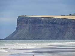
Hunt Cliff (sometimes Huntcliff or Huntcliffe) is a sea cliff or promontory, located between Saltburn and Skinningrove, in Redcar and Cleveland, on the Yorkshire Coast in England. Whilst Hunt Cliff is not as high as the nearby cliffs at Boulby, the view of it from Saltburn has been described as "very striking". Historically, the cliff has had many uses, being a signal station for the Romans, a place to mine ironstone, and a radar station during the Second World War. The Cleveland Way long-distance path traverses the cliff edge.

Contents

Description

Hunt Cliff rises some 365 feet (111 m) above the North Sea on the Yorkshire coast, [4] [3] and is 1.5 miles (2.4 km) east of the town of Saltburn. [5] Warsett Hill, the highest point of the coast here, is set back southwards from the cliff edge by 0.5-mile (0.80 km), and rises to 550 feet (170 m). [6]

The first indication of human settlement dates back to around 1300 BC, with the inhabitants most likely being farmers. [7] The top of the cliff is the site of a Roman signal station, located between the cliff edge and Warsett Hill (549 feet (167 m)) to the south. [8] [9] An archaeological investigation in 1911 discovered 14 skeletons, all of whom bore evidence of being knocked on the head. [10] The location of the old Roman fort was on the edge of the cliff, most of the remains of the site have toppled into the sea, and it is thought to have been established in 350 AD. [11] [12] Coins found at the site had been minted sometime between 370 and 400 AD. [5]

The Cleveland Way traverses the cliff edge (now also part of the England Coast Path), [13] and is also host to a railway line that used to carry passengers between Saltburn/Middlesbrough and Whitby, but which is now kept open to move freight to and from the steelworks at Skinningrove, and the potash mine at Boulby. When the line was built in the second half of the 19th century, rather than cutting direct between Brotton and Carlin How, the line loops northwards and around Huntcliff, being at the cliff edge, almost within 30 feet (9.1 m) of it. [14] [15]

The view of the cliff from Saltburn looking eastwards, has been described as being "very striking", [16] and the promontory of Hunt Cliff forms the southern edge of Tees Bay, and the start of the cliff section of coastline south towards Flamborough. [17] Huntcliff Foot, at the base of the cliff where it meets the sea, just 7.9 inches (0.2 m) above sea level, was the ancient boundary point westwards for the Port of Whitby. [18] The ports' authority extended between Scarborough in the south, and Huntcliff in the west and north. [19] From Huntcliff Foot westwards towards the Tees, the coast is quite sandy, and on the east, is very rocky. [20]

The geology of Hunt Cliff is largely that of alum shales from the Middle Lias, with a 20-foot (6.1 m) deep layer of boulder clay on the surface. [17] [21] However, a significant band of ironstone through the rock strata led to mining being carried out on the clifftop at two sites; Cliff Mine ( NZ689216 ) and Huntcliff Mine ( NZ697214 ). [22] [23] Cliff Mine operated between 1857 and 1887, though initially, the ironstone was quarried as it outcrops at the surface. Before the arrival of the railway (in 1865), quarried or mined ironstone was simply shoved over the cliff edge and shipped away by boat. [24] [25] [26] Huntcliff Mine was in operation between 1872 and 1906, and as part of its legacy, the Guibal Fanhouse, a hilltop structure that pumped fresh air into the mine, is still standing by the railway and is now a scheduled monument. [27] [28] The fanhouse at Hunt Cliff is one of fifteen built in Cleveland, and although there are two other examples, the one at Hunt Cliff retains many of its original fixtures and fittings, making it unique nationally. [29] Cliff Mine worked 85,545 tonnes (94,297 tons) in 1873 and was worth £25,664 (equivalent to £2,419,000in 2021); Huntcliff mine worked 173,220 tonnes (190,940 tons) in the same year, and was worth £55,327 (equivalent to £5,207,000in 2021). [30] Ironstone extraction has led to subsidence at the north end of Warsett Hill. [31]

Hunt Cliff was used in both World Wars, being a location for an anti-aircraft gun in the First World War, and a radar station and army camp in the Second World War. The 6 inches (150 mm) naval gun was placed on Hunt Cliff to prevent Zeppelin attacks on the Teesside industries. It was mounted upon a special railway carriage and ran on tracks that had a spur off the main railway line, and built on embankments with ironstone waste from the nearby Lumpsey Mine. [32] In the Second World War, a site at NZ686218 was used as a Coastal Defence/Chain Home Low (CD/CHL) radar location. [33] [34]

In 1991, 153 acres (62 ha) of land at the edge of Warsett Hill overlooking the sea, was purchased by the National Trust, including the Guibal Fanhouse, [35] and the area is within the North Yorkshire and Cleveland Heritage Coastline. [36] Some of the highest cliffs on the East Coast of England are in the section between Saltburn and Flamborough; whilst Boulby Cliffs are recognised as the highest at 660 feet (200 m), Hunt Cliff is still quite tall at 365 feet (111 m). [37] [38]

Wildlife

Kittiwakes, fulmars, cormorants and house martins are known to nest on the cliff. [39] [40] [41] Sightings of grey seals, harbour porpoise and minke whales have also been noted here. [42] The site is also part of the Hunt Cliff nature reserve maintained by the Tees Valley Wildlife Trust. The nature reserve covers 29 acres (12 ha) and is accessed by the Cleveland Way. [43] [44] Noted flora include the pyramidal orchid, [45] dyer's greenweed, sea plantain, wild carrot and spiny restharrow. [43]

Related Research Articles

<span class="mw-page-title-main">Saltburn-by-the-Sea</span> Town in North Yorkshire, England

Saltburn-by-the-Sea, commonly referred to as Saltburn, is a seaside town in the civil parish of Saltburn, Marske and New Marske, Redcar and Cleveland, North Yorkshire, England, around 12 miles (19 km) south-east of Hartlepool and just under 5 miles (8 km) south-east of Redcar.

<span class="mw-page-title-main">Loftus, North Yorkshire</span> Town and civil parish in North Yorkshire, England

Loftus is a market town and civil parish in the Redcar and Cleveland borough of North Yorkshire, England. The town is located north of the North York Moors and sits between Whitby and Skelton-in-Cleveland.

<span class="mw-page-title-main">Marske-by-the-Sea</span> Village in North Yorkshire, England

Marske-by-the-Sea is a village in the unitary authority of Redcar and Cleveland and the ceremonial county of North Yorkshire, England. It is located on the coast, between the seaside resorts of Redcar and Saltburn-by-the-Sea, although it is not itself a seaside resort. Marske is in the civil parish of Saltburn, Marske and New Marske and comprises the wards of Longbeck and St Germains.

<span class="mw-page-title-main">Staithes</span> Village in North Yorkshire, England

Staithes is a village in North Yorkshire, England. Easington and Roxby Becks, which run into Staithes Beck, form the border between the unitary authorities of North Yorkshire and Redcar and Cleveland. The area located on the Redcar and Cleveland side is called Cowbar. Formerly a hub for fishing and mining, Staithes is now a tourist destination in the North York Moors National Park.

<span class="mw-page-title-main">Brotton</span> Village in North Yorkshire, England

Brotton is a village in the civil parish of Skelton and Brotton, in the Redcar and Cleveland district, in the ceremonial county of North Yorkshire, England It is situated approximately 2.5 miles (4 km) south-east of Saltburn-by-the-Sea, 9 miles from Redcar, 12 miles (19 km) east of Middlesbrough and 14 miles (23 km) north-west of Whitby.

<span class="mw-page-title-main">Boulby</span> Village in North Yorkshire, England

Boulby is a hamlet in the Loftus parish, located within the North York Moors National Park. It is in the borough of Redcar and Cleveland, North Yorkshire, England. The hamlet is located off the A174, near Easington and 1-mile (1.6 km) west of Staithes.

<span class="mw-page-title-main">North Skelton</span> Village in Redcar and Cleveland, England

North Skelton is a village in Redcar and Cleveland, North Yorkshire, England.

Charltons is a village in the borough of Redcar and Cleveland and the ceremonial county of North Yorkshire, England.

<span class="mw-page-title-main">Cleveland Hills</span>

The Cleveland Hills are a range of hills on the north-west edge of the North York Moors in North Yorkshire, England, overlooking Cleveland and Teesside. They lie entirely within the boundaries of the North York Moors National Park. Part of the 110-mile (177 km) long Cleveland Way National Trail runs along the hills, and they are also crossed by a section of Wainwright's Coast to Coast Walk. The hills, which rise abruptly from the flat Tees Valley to the north, include distinctive landmarks such as the cone-shaped peak of Roseberry Topping, near the village of Great Ayton – childhood home of Captain James Cook.

<span class="mw-page-title-main">Whitby, Redcar and Middlesbrough Union Railway</span> Former railway line in Yorkshire, England

The Whitby, Redcar and Middlesbrough Union Railway (WRMU), a.k.a. the Whitby–Loftus Line, was a railway line in North Yorkshire, England, built between 1871 and 1886, running from Loftus on the Yorkshire coast to the Esk at Whitby, and connecting Middlesbrough to Whitby along the coast.

<span class="mw-page-title-main">Yorkshire Coast</span> Coastline of Yorkshire, England

The Yorkshire Coast runs from the Tees estuary to the Humber estuary, on the east coast of England. The cliffs at Boulby are the highest on the east coast of England, rising to 660 feet (200 m) above the sea level.

<span class="mw-page-title-main">Port Mulgrave, North Yorkshire</span> Former port in North Yorkshire, England

Port Mulgrave is a derelict former ironstone exporting port on the North Yorkshire coast midway between Staithes and Runswick Bay in the civil parish of Hinderwell. Rows of domestic properties and individual houses exist on the top of the cliff.

<span class="mw-page-title-main">Kettleness</span> Hamlet in North Yorkshire, England

Kettleness, is a hamlet in the Scarborough District of North Yorkshire, England. The settlement only consists of half-a-dozen houses, but up until the early 19th century, it was a much larger village. However, most of that village, which was on the headland, slipped into the sea as a result of instability caused by quarrying for the alum industry. Kettleness became a smaller settlement, with houses rebuilt slightly further inland.

<span class="mw-page-title-main">Grinkle Mine</span> Former ironstone mine in North Yorkshire, England

Grinkle Mine, was an ironstone mine working the main Cleveland Seam near to Roxby in North Yorkshire, England. Initially, the ironstone was mined specifically for the furnaces at the Palmer Shipbuilders in Jarrow on the River Tyne, but later, the mine became independent of Palmers. To enable the output from the mine to be exported, a 3-mile (4.8 km) narrow-gauge tramway was constructed that ran across three viaducts and through two tunnels to the harbour of Port Mulgrave, where ships would take the ore directly to Tyneside.

North Skelton Mine was an ironstone mine in the village of North Skelton in North Yorkshire, England. The mine was the deepest of the ironstone mines in Cleveland and was also the last to close, which came in January 1964. Some buildings still exist on the surface as well as spoil heaps.

<span class="mw-page-title-main">Ironstone mining in Cleveland and North Yorkshire</span> Ironstone mines and quarries in Cleveland and North Yorkshire, England

Ironstone mining in Cleveland and North Yorkshire occurred on a sizeable scale from the 1830s to the 1960s in present day eastern parts of North Yorkshire but has been recorded as far back as Roman times in mostly a small-scale and intended for local use. This Cleveland is not to be confused with a smaller area covered by the county of Cleveland from 1974-96.

<span class="mw-page-title-main">Kilton Viaduct</span> Viaduct in Yorkshire, England

Kilton Viaduct was a railway viaduct that straddled Kilton Beck, near to Loftus, in North Yorkshire, England. The viaduct was opened to traffic in 1867, however in 1911, with the viaduct suffering subsidence from the nearby ironstone mining, the whole structure was encased in waste material from the mines creating an embankment which re-opened fully to traffic in 1913. The railway closed in 1963, but then in 1974, it re-opened as part of the freight line to Boulby Mine carrying potash traffic.

<span class="mw-page-title-main">Saltburn Viaduct</span> Viaduct in Redcar and Cleveland, England

Saltburn Viaduct, is a railway bridge in Redcar and Cleveland, North Yorkshire, England. The line was built as an extension of the Redcar and Saltburn Railway, and the viaduct is mostly built out of brick. The line opened to passengers in 1872, but became freight only in 1957, a purpose for which it still is in use for today as part of the Boulby line.

<span class="mw-page-title-main">Boulby line</span> Railway in North-East England

The Boulby line is a freight-only railway line in Redcar and Cleveland, England. The line was opened in stages between 1865 and 1882, being part of two railways that met at Brotton railway station. Passenger trains along the line ceased in 1960, and since then it has been a freight-only line dedicated to the potash and polyhalite traffic from Boulby, and steel products into Skinningrove Steelworks.

References

  1. Cowley, Bill (1977). The Cleveland Way; Yorkshire moors and coast footpath. Clapham: Dalesman Books. p. 64. ISBN   0-85206-394-6.
  2. "Hunt Cliff, Redcar and Cleveland - area information, map, walks and more". getoutside.ordnancesurvey.co.uk/. Retrieved 21 January 2024.
  3. 1 2 Pidd, Helen (26 March 2017). "Tributes paid to two boys found dead at foot of cliffs in Teesside". The Guardian. Retrieved 20 January 2024.
  4. Wingham 2021, p. 18.
  5. 1 2 Pevsner, John (2002) [1966]. Yorkshire, the North Riding. London: Yale University Press. p. 316. ISBN   0300096658.
  6. Hornsby, W.; Stanton, R. (1912). "The Roman fort at Huntcliff, near Saltburn". The Journal of Roman Studies. Cambridge: Cambridge University Press. 2: 224. ISSN   0075-4358.
  7. Wingham 2021, p. 15.
  8. Leyland, John (1892). The Yorkshire Coast and the Cleveland Hills and Dales. London: Seeley and Company. p. 26. OCLC   50322148.
  9. Brandon, David (2010). Along the Yorkshire coast : from the tees to the Humber. Stroud: History Press. p. 30. ISBN   9780752457321.
  10. Barker, Malcolm G. (2007). Essence of the Yorkshire coast. Ilkley: Great Northern Books. p. 7. ISBN   9781905080397.
  11. "Georeferenced Maps - Map images - National Library of Scotland". maps.nls.uk. Retrieved 20 January 2024. Use the slider on the bottom left (named "Change transparency of overlay") to toggle between old mapping and modern-day satellite imagery
  12. Bainbridge, Norman (1977). Saltburn-by-the-Sea. Redcar: Sotheran. p. 9. ISBN   0-905032-07-1.
  13. "306" (Map). Middlesbrough & Hartlepool. 1:25,000. Explorer. Ordnance Survey. 2015. ISBN   978-0-319-24558-3.
  14. "Railway extensions in Yorkshire". York Herald. No. 5575. 21 December 1874. p. 7. OCLC   1325754826.
  15. North, G. A. (1975). Teesside's Economic Heritage. Cleveland County Council. p. 46. OCLC   611236534.
  16. Phillips, John (1853). The rivers, mountains, and sea-coast of Yorkshire : with essays on the climate, scenery, and ancient inhabitants of the county. London: J. Murray. p. 14. OCLC   1084519889.
  17. 1 2 Motyka 1986, p. 8.
  18. "Huntcliff Foot, Redcar and Cleveland - area information, map, walks and more". getoutside.ordnancesurvey.co.uk. Retrieved 20 January 2024.
  19. Page, William (1968). The Victoria history of the county of York, North Riding, volume 2. London: Dawsons of Pall Mall for the University of London Institute of Historical Research. p. 505. ISBN   0712903100.
  20. Bowes, Ida (1948). Cleveland and Tees-Side. A geographical study of population and occupational changes since 1800. London: Bedford College (University of London). p. 52. ISBN   978-1-339-61283-6.
  21. Hornsby, W.; Stanton, R. (1912). "The Roman fort at Huntcliff, near Saltburn". The Journal of Roman Studies. Cambridge: Cambridge University Press. 2: 217. ISSN   0075-4358.
  22. Tuffs 1996, pp. 10, 16.
  23. "Cliff Ironstone Mine". east-clevelands-industrial-heartland.co.uk. 29 November 2019. Retrieved 20 January 2024.
  24. "Disused Stations: Brotton Station". disused-stations.org.uk. Retrieved 20 January 2024.
  25. Tuffs 1996, p. 11.
  26. Wilson, Chris Scott (1983). The history of Saltburn. Cleveland: Seaside Books. p. 41. ISBN   0-9508631-0-6.
  27. Historic England. "Huntcliffe Guibal fan house (1006742)". National Heritage List for England . Retrieved 20 January 2024.
  28. "Huntcliff Ironstone Mine". heritagegateway.org.uk. Retrieved 20 January 2024.
  29. "National Trust Holdings on the North Yorkshire Coast" (PDF). library.oxfordarchaeology.com. Oxford Archaeology North. August 2007. p. 126. Retrieved 25 January 2024.
  30. Owen, John S. (1986) [1979]. Cleveland Ironstone Mining. Cleveland Industrial Archaeological Society. pp. 31–32. ISBN   0-9506863-2-8.
  31. Wilson, Chris Scott (1983). The history of Saltburn. Cleveland: Seaside Books. p. 65. ISBN   0-9508631-0-6.
  32. Harwood, John Middleton (2008). Defence of the UK, Cleveland volume 4 part 2. North Yorkshire and Cleveland 20th Century Defence Study Group. pp. 45–46. ISBN   978-1-906922-08-5.
  33. Dobinson, Colin (2010). Building radar: forging Britain's early-warning chain, 1935-45. London: Methuen. p. 624. ISBN   978-0-413-77229-9.
  34. Harwood, John Middleton (2008). Defence of the UK, Cleveland volume 4 part 2. North Yorkshire and Cleveland 20th Century Defence Study Group. p. 47. ISBN   978-1-906922-08-5.
  35. Davenport, Peter (22 May 1991). "Trust buys patch of Cleveland coast". The Times. No. 64025. p. 3. ISSN   0140-0460.
  36. "Heritage Coasts (England)". naturalengland-defra.opendata.arcgis.com. Retrieved 25 January 2024.
  37. Motyka 1986, p. 24.
  38. Winn, Christopher (2010). I never knew that about Yorkshire. London: Random House. p. 85. ISBN   978-0-09-193313-5.
  39. Coulson, J. C. (September 1963). "The status of the Kittiwake in the British Isles". Bird Study. 10 (3): 177. doi:10.1080/00063656309476048.
  40. Garnett, M., ed. (April–June 1949). "The Yorkshire Naturalists Union (Vertebrate Section) Committee for Ornithology". The Naturalist. London: A.  Brown and Sons (829): 68. OCLC   1049891387.
  41. Fisher, James; Waterston, George (November 1941). "The Breeding Distribution, History and Population of The Fulmar (Fulmarus glacialis) in the British Isles". Journal of Animal Ecology. British Ecological Society. 12 (2): 211. ISSN   0021-8790.
  42. Neale, Stephen (2020). The England Coast Path: 1,000 Mini Adventures Around the World's Longest Coastal Path. London: Bloomsbury. p. 245. ISBN   978-1-8448-6579-6.
  43. 1 2 "Hunt Cliff". teeswildlife.org. Retrieved 20 January 2024.
  44. "Hunt Cliff Nature Reserve in Saltburn". saltburn.org.uk. 3 January 2023. Retrieved 20 January 2024.
  45. "Old Saltburn to Warsett Hill walk | Yorks". nationaltrust.org.uk. Retrieved 21 January 2024.

Sources