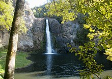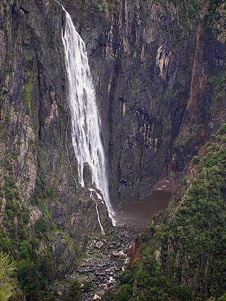
The Wollomombi Falls is a plunge waterfall on the Wollomombi River in the New England region of New South Wales, Australia.
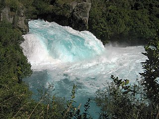
Huka Falls is a set of waterfalls on the Waikato River, which drains Lake Taupō in New Zealand.
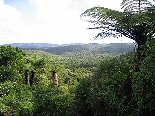
The Waitākere Ranges is a mountain range in New Zealand. Located in West Auckland between metropolitan Auckland and the Tasman Sea, the ranges and its foothills and coasts comprise some 27,720 hectares of public and private land. The area, traditionally known to Māori as Te Wao Nui o Tiriwa, is of local, regional, and national significance. The Waitākere Ranges includes a chain of hills in the Auckland Region, generally running approximately 25 kilometres (16 mi) from north to south, 25 km west of central Auckland. The ranges are part of the Waitākere Ranges Regional Park.

The Hunua Ranges is a mountain range and regional park to the southeast of Auckland city, in the Auckland and Waikato regions of New Zealand's North Island. The ranges cover some 250 square kilometres (97 sq mi) and rise to 688 metres (2255 ft) at Kohukohunui.

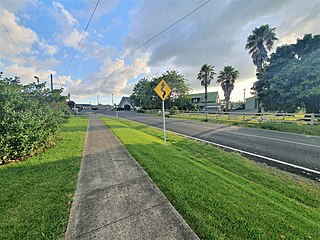
Clevedon, previously known as Wairoa South, is a rural town to the south-east of Auckland, New Zealand, located in Franklin. The area is a part of the rohe of Ngāi Tai ki Tāmaki, who settled around the Wairoa River. The township was founded in the 1850s, and was named Clevedon in 1866. Over time, Clevedon developed into a centre for the dairy industry in south-eastern Auckland.
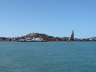
Takarunga / Mount Victoria the highest volcano on Auckland's North Shore, rising to 66 m. Its age is currently unknown. Its lava flows now line much of Devonport's waterfront. Takarunga was the location of an important pā used by Tāmaki Māori peoples. In the late 19th century, a gun fort was built on top of the hill, in order to defend the city of Auckland. As a designated tūpuna maunga, the mountain has been governed by the Tūpuna Maunga Authority, along with thirteen other cones throughout Auckland, since 2014.

The Purakaunui Falls are a cascading three-tiered waterfall on the Purakaunui River, in The Catlins of the southern South Island of New Zealand. As one of very few South Island waterfalls away from the alpine region, it has long been a popular destination and photographic subject.
The Wairoa River runs north into Tauranga Harbour at the western end of the Bay of Plenty in New Zealand's North Island.

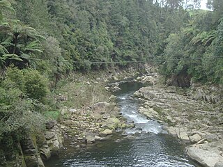
The Wairoa River, also known as Wairoa South, is the second longest river in the Auckland Region of New Zealand's North Island. It flows north from its sources in the Hunua Ranges into the Hauraki Gulf, and passes adjacent to the township of Clevedon. The Hunua Falls form a section of the river.
Kitekite Falls is a scenic 3-tiered waterfall near Auckland, New Zealand. The falls drop a total of 40 metres (130 ft). From the lookout on Kitekite track the falls appear even higher because there is white water running over rocks into a small pool from the upper swimming hole, then falling down into a large pool, then falling to a small pool before beginning an almost vertical descent in the final 3-tiers, making the total height closer to 80 metres (260 ft). They are located on the Glen Esk stream near Piha Beach.

Dawson Falls is one of seven waterfalls on the Murtle River in Wells Gray Provincial Park, British Columbia, Canada.

The Rainbow Falls, Māori name Waianiwaniwa,, are a single-drop waterfall located on the Kerikeri River near Kerikeri in New Zealand.

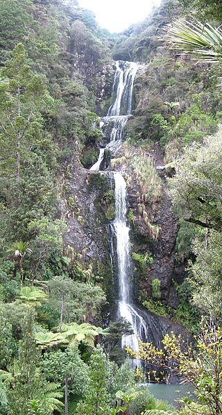
Bridal Veil Falls is a plunge waterfall located along the Pakoka River in the Waikato area of New Zealand. The waterfall is 55 m (180 ft) high, and has over time caused the formation of a large pool at the base of the waterfall. The falls are in the 217 ha Wairēinga Scenic Reserve with tawa-dominated forest.

The Auckland Region of New Zealand is built on a basement of greywacke rocks that form many of the islands in the Hauraki Gulf, the Hunua Ranges, and land south of Port Waikato. The Waitākere Ranges in the west are the remains of a large andesitic volcano, and Great Barrier Island was formed by the northern end of the Coromandel Volcanic Zone. The Auckland isthmus and North Shore are composed of Waitemata sandstone and mudstone, and portions of the Northland Allochthon extend as far south as Albany. Little Barrier Island was formed by a relatively isolated andesitic volcano, active around 1 to 3 million years ago.
Hunua is a small settlement in the rural outskirts of south Auckland, New Zealand.
The Mangatangi River, or Mangatangi Stream, originates on the eastern slopes of the Hunua Ranges in New Zealand and flows roughly southwards until it is joined by the Ruaotehuia Stream just north of State Highway 2 between Mangatāwhiri and Maramarua, where it becomes the Maramarua River. Mangatangi can be translated as manga tangi to stream of weeping, or as rippling stream, or babbling brook.

Wainui Falls is a 20-metre (66 ft) waterfall in Wainui Bay, in the Tasman region of New Zealand. The waterfall is part of the Wainui River and cascades over granite bedrock into a deep pool at its base. It is the largest and most accessible waterfall in the Abel Tasman National Park and the Nelson-Golden Bay area, and can be reached via the short Wainui Falls Track. The track is popular as a day walk among tourists, and while the waters of the Wainui River can be too cold for swimming much of the year, the plunge pool is a favoured swimming hole in the summer months.

Waharau Regional Park is a regional park situated in the Hauraki District and the Waikato Region of New Zealand's North Island, four kilometres north of Whakatīwai Regional Park. It is just south of the border with the Auckland Region, and is owned and operated by Auckland Council. It runs from the eastern side of the Hunua Ranges, where it adjoins Hunua Ranges Regional Park, down to the Firth of Thames coast.

The South Auckland volcanic field, also known as the Franklin Volcanic Field, is an area of extinct monogenetic volcanoes around Pukekohe, the Franklin area and north-western Waikato, south of the Auckland volcanic field. The field contains at least 82 volcanoes, which erupted between 550,000 and 1,600,000 years ago.
The Auckland regional faults have low seismic activity compared to much of New Zealand but do result in an earthquake risk to the Auckland metropolitan area, New Zealand's largest city. There is also evidence of past tectonic, volcanic associations in a city located within what is, at best, a very recently dormant Auckland volcanic field.