The Wairoa River, also known as Wairoa South, is the second longest river in the Auckland Region of New Zealand's North Island. It flows south from its sources in the Hunua Ranges, then northwards into the Hauraki Gulf. The Wairoa Reservoir and Hūnua Falls form sections of the river, and the Wairoa River flows adjacent to the township of Clevedon.
The river begins in the central Hunua Ranges, flowing south to the Wairoa Reservoir, and once exiting the Hunua Ranges changing course to flow northwards. [1] Paparimu Road and Hunua Road follow the course of the river as it flows northwards through farmland. Much of the western Hunua Ranges flows into the Wairoa River, including Cosseys Creek and the Ōtau Valley, both of which have been dammed as freshwater reservoirs. [2] [3] [4] In addition to these, the Wairoa River is joined by other tributaries: the Mangawheau Stream, [5] the Hunua Stream which flows past the settlement of Hūnua, [6] and the Taitaia Stream, which meets the Wairoa River north of Clevedon. [7] Past Clevedon, the river veers north-east, meeting the Urungahauhau Stream and the Aroaro Stream of the Ness Valley and forming an estuary. [8] [9] The estuary reaches the Hauraki Gulf at Pouto Point in the east. [10]
The river first formed during the Pliocene era, approximately 3 to 4 million years ago. Originally it was a westwards-flowing river, flowing into the proto-Manukau Harbour past Weymouth. [11] Much of the river flows along the Wairoa River Gorge, formed along a fault line. The Hūnua Falls, a 30 metre high waterfall, flows overtop of an ancient volcanic plug. [12]
The Wairoa River's traditional name, Te Wairoa ("The Great River") was named by early Ngāi Tai ki Tāmaki ancestors of the Tainui waka, referencing Te Vairoa in Rarotonga, which in turn took its name from a similarly named river in Tahiti. [13] Te Wairoa was a name applying to the river mouth and surrounding area, while Ōtau referred to the upstream areas further, including where the river passes by Clevedon. [13] The early Tāmaki Māori hapū of the Wairoa river valley between the 14th and 16th centuries included Te Ngungukauri, Te Uri Kupai, Ngāti Ruangaingai and Ngāti Parahanga, who identified as both Ngāti Tai Manawaiti, and Ngā Iwi (Waiohua). The related hapū were united under the rangatira Te Wana in the early 18th century, under the name Ngāti Tai (now more widely known as Ngāi Tai ki Tāmaki). [13] The river mouth formed the traditional heartland of Ngāi Tai ki Tāmaki. [14] Ngāi Tai peoples traditionally lived in seasonal cycles, focusing on fishing and shellfish collecting, cultivations and collecting berries and snaring birds in the river's upper reaches, depending on the season. [13] The river-mouth was used as a summer pioke (Shortspine spurdog shark) fishing ground, which were dried for the winter months. [13] [15] Ngāi Tai settled at many pā and kāinga along the river, especially at the river's mouth. [16]
In November of 1769, Captain Cook visited the Hauraki Gulf area. Cook gifted potatoes to senior members of Te Uri ō Pou from Ōrere, who then planted these at Te Hūnua, along the Wairoa River (likely near modern-day Clevedon). These were the first crop of potatoes grown in New Zealand, and three years later, potatoes were gifted during a feast at Te Hūnua to the tribes of the Hauraki Gulf and Waikato, becoming some of the first varieties of rīwai (Māori potatoes) in New Zealand. [13]
When William Thomas Fairburn visited the area in 1833, it was mostly unoccupied due to the events of the Musket Wars, as most members of Ngāi Tai had fled to temporary refuge in the Waikato. [15] [14] In 1836, Fairburn purchased 40,000 acres between Ōtāhuhu and Umupuia (Duders Beach), including much of the catchment of the Wairoa River. [14] Fairburn's Purchase was investigated by the New Zealand Land Commission in 1841 and 1842 and found to be excessive and reduced in size. The disallowed parts of his purchase were not returned to Ngāi Tai, however in 1854 a reserve was created for Ngāi Tai between the eastern shores of the Wairoa River and Maraetai/Umupuia. [14]
From 1854, European farming settlers began to arrive on the banks of the Wairoa River, forming the township of Clevedon. [13] Ngāi Tai held a defended settlement on the eastern banks of the Wairoa River opposite Clevedon, known as Ōtau. During the first decade post European settlement, Ngāi Tai and the European settlers had cordial relations, trading goods and assisting each other. [13] In September 1863 during the Invasion of the Waikato, Ōtau was attacked by the British army, and the village was evacuated. After which, the residents moved to live in communities at the river's mouth. For the remainder of the war, Ngāi Tai were designated as a "friendly" people by the Crown, and remained neutral in the fighting. [13] After the Native Lands Act of 1865, the Native Land Court individuated the collective Ngāi Tai lands, and in the process the majority of land near the Wairoa River was alienated and sold to European farmers. [13] During European settlement, most of the Wairoa River catchment was deforested. [17]
In the early 1900s, the river mouth became popular with Auckland residents for duck shooting and picnicking. [15] In 1955, the Cosseys Creek Dam was constructed in the Hunua Ranges, a rolled earth dam constructed to secure fresh water supplies for Auckland. [3] This was joined by the Wairoa Ram in 1975. [4] The construction of the dams significantly reduced the flow of the Wairoa River. [18]
In 2002, the Auckland Regional Council began developing a management strategy for the river, with was further developed in 2016 with the founding of the Wairoa River Steering Group, now a part of the volunteer conversation group Friends of Te Wairoa Catchment, which formed in 2017. [17] [19] In 2017, the Wairoa River won a New Zealand River Award for being the most improved river in the Auckland Region. [19]
The lower Wairoa River north of Clevedon is navigable by boats and canoes. [18]
The Hunua Ranges is a mountain range and regional park to the southeast of Auckland city, in the Auckland and Waikato regions of New Zealand's North Island. The ranges cover some 250 square kilometres (97 sq mi) and rise to 688 metres (2255 ft) at Kohukohunui.
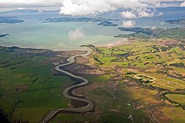
Clevedon, previously known as Wairoa South, is a rural town to the south-east of Auckland, New Zealand, in the local government area of Franklin. The area is part of the rohe of Ngāi Tai ki Tāmaki, who settled around the Wairoa River. The original township was founded in the 1850s, and was named Clevedon in 1866. Over time, it has developed into a centre for the dairy industry south-east of Auckland.
Pakuranga is an eastern suburb of Auckland, in northern New Zealand. Pakuranga covers a series of low ridges and previously swampy flats, now drained, that lie between the Pakuranga Creek and Tamaki River, two estuarial arms of the Hauraki Gulf. It is located to the north of Manukau and 15 kilometres southeast of the Auckland CBD.
Bucklands Beach is a suburb 13 kilometres (8.1 mi) east of Auckland's CBD in New Zealand. The suburb is in the Howick ward, one of the thirteen administrative divisions of Auckland Council.
Beachlands is an outer suburb of Auckland, New Zealand, established in the 1920s, where development increased in the 1950s due to its popularity as a beach holiday destination. It is located on the Pōhutukawa Coast and in close proximity to Maraetai.
East Auckland is one of the major geographical regions of Auckland, the largest city in New Zealand. Settled in the 14th century, the area is part of the traditional lands of Ngāi Tai ki Tāmaki. The area was developed into farmland in the 1840s, and the town of Howick was established as a defensive outpost by fencibles to protect Auckland. Coastal holiday communities developed in the area from the 1910s, and from the 1950s underwent major redevelopment into a suburban area of greater Auckland. From the 1980s, the area saw significant Asian New Zealander migrant communities develop.
Ngāi Tai ki Tāmaki is a Māori tribe that is based in the area around Clevedon, part of the Auckland region. It is one of the twelve members of the Hauraki Collective of tribes.
Maraetai is a coastal town to the east of Auckland in New Zealand, on the Pōhutukawa Coast. Part of the traditional rohe of Ngāi Tai Ki Tāmaki, the area developed into a coastal holiday community in the early 20th Century.
Half Moon Bay, is a suburb of East Auckland, New Zealand, lying immediately south of Bucklands Beach. It is home to the Half Moon Bay Marina, where over 500 boats berth. It is located on the Tāmaki River in the Hauraki Gulf.
Duder Regional Park is a regional park situated on the coast to the east of Auckland, New Zealand, on the Whakakaiwhara Peninsula.
Ōtara is a suburb of South Auckland, New Zealand, situated 18 kilometres to the southeast of the Auckland City Centre. Ōtara lies near the head of the Tamaki River. The area is traditionally part of the rohe of Ngāi Tai ki Tāmaki, and the name Ōtara refers to Ōtara Hill / Te Puke ō Tara, a former Ngāi Tai ki Tāmaki pā and volcanic hill to the north of the suburb. From 1851 to 1910 the area was part of the Goodfellow family farm, and during the 1910s the area was an agricultural college run by the Dilworth Trust.
Highbrook is a suburb located in the city of Auckland, in the North Island of New Zealand. The area is on the eastern side of the Auckland city centre and is a large industrial area developed only in recent years. The area is under governance of the Auckland Council, and is home to a large bulk of New Zealand and international businesses and organisations.
Sunnyhills is a suburb of East Auckland, New Zealand, located on the eastern banks of the Tāmaki River near Pakuranga. Previously farmland within the Pakuranga Town District, suburban housing developed in the area in the mid-1960s.
Golflands is an eastern suburb of the city of Auckland, New Zealand. The Pakuranga Golf Club is part of the suburb, and many of the streets have names related to golf or notable golf players, such as Bob Charles drive.
The Ōtara Creek, is a major stream in South Auckland, in the Auckland Region of New Zealand's North Island. It flows northwards, then westwards into the Tāmaki River.
Magazine Bay is a bay in the Auckland Region of New Zealand's North Island. It is located to the east of Maraetai.
The Pōhutukawa Coast is an area of the Auckland Region in New Zealand. The area covers townships south of the Tāmaki Strait: Whitford, Beachlands, Maraetai and Umupuia. The area was traditionally known as Maraetai, and is within the rohe of Ngāi Tai ki Tāmaki. In the 1920s, seasonal holiday communities developed in the area, which became permanent residential towns by the 1950s.
Tūranga Creek, also known as the Tūranga River or Tūranga Estuary, is a stream and tidal estuary in the Auckland Region of New Zealand's North Island. The township of Whitford was founded at the navigable headlands of the creek.
Pakuranga Creek is a tidal estuary and stream in the Auckland Region of New Zealand's North Island. The creek flows from inlant Pakuranga, meeting the Pakuranga Stream and flows into the Tāmaki River.
Tara Te Irirangi (1780s–1852) also known as Te Tara ki Moehau or Ōtara Te Irirangi, was paramount chief of Ngāi Tai ki Tāmaki or Ngāti Tai, a Māori tribe of the eastern Auckland region of New Zealand, encompassing parts of the Hauraki Gulf and Wairoa Valley, as well as Ōtara, Clevedon, Maraetai and Howick. Te Irirangi was the great-grandson of Te Wana, a leading rangatira and well-known warrior of Ngāi Tai, who, during his life, strengthened Ngāi Tai control over the Maraetai-Wairoa area. Tara Te Irirangi died in 1852, after falling ill, and passed away at the mouth of the Wairoa River. He was interred in his waka in the Ngāi Tai burial swamps within the west bank of the river.