
Coromandel, also called Coromandel Town to distinguish it from the wider district, is a town on the Coromandel Harbour, on the western side of the Coromandel Peninsula, which is in the North Island of New Zealand. It is 75 kilometres east of the city of Auckland, although the road between them, which winds around the Firth of Thames and Hauraki Gulf coasts, is 190 km long. The population was 1,960 as of June 2022.

Drury is a rural town near Auckland, in northern New Zealand. Located 36 kilometres to the south of Auckland CBD, under authority of the Auckland Council. Drury lies at the southern border of the Auckland metropolitan area, 12 kilometres to the northeast of Pukekohe, close to the Papakura Channel, an arm of the Manukau Harbour.
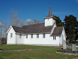
Pōrangahau, a township close to the Pacific Ocean coast in the south-east of the North Island of New Zealand, has a very small population. It lies in the southernmost part of Hawke's Bay, 45 kilometres south of Waipukurau, and close to the mouth of the Porangahau River. The settlement includes a marae and a school.

The Bombay Hills are a range of hills to the south of Auckland, New Zealand. Though only a small and seemingly insignificant range of hills, they lie at the southern boundary of the Auckland region, and serve as a divide between Auckland and the Waikato region. There is a 19th-century settlement, Bombay, on the old main road south of Auckland, the Great South Road.
Clevedon, previously known as Wairoa South, is a rural town in Auckland, New Zealand, located in the Franklin ward, one of the thirteen administrative divisions of Auckland city. The town is governed by the Auckland Council. The town is the centre of an administrative ward of Franklin which takes in much of the largely rural area to the east of the urban heart of the city.
Helensville is a town in the North Island of New Zealand. It is sited 40 kilometres (25 mi) northwest of Auckland, close to the southern extremity of the Kaipara Harbour. State Highway 16 passes through the town, connecting it to Waimauku 16 kilometres (10 mi) to the south, and Kaukapakapa about 12 kilometres (7.5 mi) to the north-east. Parakai is two kilometres (1.2 mi) to the north-west.
Ramarama, previously known as Sheppards Bush, is a small community at the far south of the Auckland Region in New Zealand's North Island, located just to the north of the Bombay Hills. Ramarama has an off-ramp at exit 466 on the motorway south of Auckland. The suburb is effectively sliced in two by the motorway, this section of which was constructed in 1978.
Red Hill is a suburb of Auckland, in northern New Zealand. Located 34 kilometres (21 mi) to the southeast of Auckland CBD, under authority of the Auckland Council. The suburban area of Red Hill makes up the southernmost part of the Auckland metropolitan area, however the majority of the area is rural. The suburb lies on an ancient Pā Site known in Māori as Pukekiwiriki. The area is also situated on a no longer active volcano, and an old fault line in the region. Red Hill is located in the Manurewa-Papakura ward, one of the thirteen administrative divisions of Auckland city.

Pōkeno is a small town in the Waikato District of the Waikato region in New Zealand, 53 km (33 mi) southeast of Auckland, 9 km (5.6 mi) from Tuakau and 5 km (3.1 mi) from Mercer. State Highway 1 originally ran through the town, but the upgrading of the highway in 1992 to expressway standards mean that the town has been bypassed.

Ōrere Point is a rural township in the Auckland Region. It is located on the Hauraki Gulf just outside the Auckland metropolitan area. Facilities include a local store, playground, campground, picnic area, parking and limited mobility toilets. Activities include wild life watching, fishing and swimming.
Clover Park is a suburb of Auckland, New Zealand. It is governed by the Auckland Council, and is in the Manukau ward, one of the thirteen administrative divisions of Auckland city.
Tauhoa is a rural community in the Auckland Region of New Zealand's North Island.

Cust is a rural village in the South Island of New Zealand. It is located in North Canterbury and comes under seat of the Waimakariri District Council. It is located approximately 16 km east of Oxford and 17 km west of Rangiora. The town is named after Sir Edward Cust, who was a member of the Canterbury Association which organised European settlement of the area around 1850. Earlier names for the town were Moeraki Downs and Middleton-on-the-Cust.
Stirling is a settlement in New Zealand. It is located in South Otago, approximately 5 km from Balclutha, and just north of the Matau Branch of the Clutha River.
Tai Tapu, previously known as Taitapu, is a small town adjacent to the Halswell River and nestled in the Port Hills, located 6 km east of the town of Lincoln and 18 km south west of Christchurch in the Canterbury region of New Zealand's South Island. State Highway 75 passes through the centre of the village, connecting Christchurch with Akaroa and the Banks Peninsula.
Ngāhinapōuri is a rural community in the Waipa District and Waikato region of New Zealand's North Island. It is located on State Highway 39, between Whatawhata and Pirongia.

Waiau Pa is a small town of Auckland, New Zealand. It is in the Franklin Ward of Auckland Council. The name means "River of swirling currents" in the Māori language.
Mahurangi West is a rural settlement in the Auckland Region of New Zealand. Puhoi is to the west, Mahurangi Harbour is to the east, and the western part of Mahurangi Regional Park is southeast.

Point Wells is a rural settlement in the Auckland Region of New Zealand, at the tip of a peninsula between the Omaha River and Whangateau Harbour. Omaha is across the harbour but accessible by a causeway.

Scotts Landing, also called Mahurangi East, is a rural settlement in the Auckland Region of New Zealand. It is at the end of a narrow peninsula on the eastern side of Mahurangi Harbour. Algies Bay is to the north.

