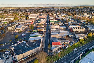
Pukekohe is a town in the Auckland Region of the North Island of New Zealand. Located at the southern edge of the Auckland Region, between the southern shore of the Manukau Harbour and the mouth of the Waikato River. The hills of Pukekohe and nearby Bombay Hills form the natural southern limit of the Auckland region. Pukekohe is located within the political boundaries of the Auckland Council, following the abolition of the Franklin District Council on 1 November 2010.

Tuakau is a town in the Waikato region at the foot of the Bombay Hills, formerly part of the Franklin District until 2010, when it became part of Waikato District in the North Island of New Zealand. The town serves to support local farming, and is the residence of many employees of New Zealand Steel at Glenbrook.

Auckland is one of the 16 regions of New Zealand, which takes its name from the eponymous urban area. The region encompasses the Auckland metropolitan area, smaller towns, rural areas, and the islands of the Hauraki Gulf. Containing 34 percent of the nation's residents, it has by far the largest population and economy of any region of New Zealand, but the second-smallest land area.

Drury is a rural town near Auckland, in northern New Zealand. Located 36 kilometres to the south of Auckland CBD, under authority of the Auckland Council. Drury lies at the southern border of the Auckland metropolitan area, 12 kilometres to the northeast of Pukekohe, close to the Papakura Channel, an arm of the Manukau Harbour.

Glenbrook is a rural and industrial area in the Auckland region of New Zealand. The industrial area, that of New Zealand's major steel mill, New Zealand Steel, is not located close to any towns - the surrounding countryside is occupied by farms. The nearest towns are Waiuku, five kilometres to the south, and Pukekohe, 15 kilometres to the east.

Ngatea is a small town on the Hauraki Plains in the North Island of New Zealand. It is located 18 kilometres southwest of Thames and 70 kilometres southeast of Auckland. Ngatea lies on the Piako River, eight kilometres south of its outflow into the Firth of Thames.

Port Waikato is a New Zealand town that sits on the south bank of the Waikato River, at its outflow into the Tasman Sea, in the northern Waikato.

Te Kauwhata is a small town in the north of the Waikato region of New Zealand, situated close to the western shore of Lake Waikare, some 40 km north of Hamilton and approximately 58 km south of Manukau City. The township is surrounded by dairy farms, drystock holdings and horticulture. Its newest building is its Waikato District Council library. Originally known as Wairangi, Te Kauwhata grew around a railway station built in the late 1870s.

The Bombay Hills are a range of hills to the south of Auckland, New Zealand. Though only a small and seemingly insignificant range of hills, they lie at the southern boundary of the Auckland region, and serve as a divide between Auckland and the Waikato region. There is a 19th-century settlement, Bombay, on the old main road south of Auckland, the Great South Road.

Clevedon, previously known as Wairoa South, is a rural town to the south-east of Auckland, New Zealand, in the local government area of Franklin. The area is part of the rohe of Ngāi Tai ki Tāmaki, who settled around the Wairoa River. The original township was founded in the 1850s, and was named Clevedon in 1866. Over time, it has developed into a centre for the dairy industry south-east of Auckland.
Ramarama, previously known as Sheppards Bush, is a small community at the far south of the Auckland Region in New Zealand's North Island, located just to the north of the Bombay Hills. Ramarama has an off-ramp at exit 466 on the motorway south of Auckland. The suburb is effectively sliced in two by the motorway, this section of which was constructed in 1978.

Mellons Bay is a suburb of East Auckland. It is south of Eastern Beach and north of Howick.

Karaka is a small rural area in the south of Auckland, New Zealand. Formerly part of Franklin District and under the authority of the Franklin District Council, it is now part of Auckland Council following the amalgamation of the Auckland region's councils.
Onewhero is a village and rural community in the Waikato District and Waikato region of New Zealand's North Island.

Te Kawa is a rural community in the Ōtorohanga District and Waikato region of New Zealand's North Island. It lies just to the south of the volcanic hills of Kakepuku and Te Kawa. Until the swamp was drained in the 1900s, Te Kawa was well known for its eels.
Paerata is a small settlement immediately to the north of Pukekohe, in the North Island of New Zealand. It is located on State Highway 22 some 10 kilometres (6.2 mi) south of the Manukau Harbour. Wesley College is located close to the northern edge of Paerata.

Waerenga is the name of a hamlet, 11 km (6.8 mi) east of Te Kauwhata, which is part of a statistical area unit in the Waikato District.

Gordonton is a village and rural community in the Waikato District and Waikato region of New Zealand's North Island. It is located southeast of Taupiri on State Highway 1B.
Pukeatua is a rural farming community in Waipa District and Waikato region of New Zealand's North Island. It is situated at the south-western foot of the Pukeatua hill, of the Maungatautari mountain range.

Motumaoho is a small village in the Waikato region of New Zealand's North Island, just to the west of the Pakaroa Range. It is on SH26, 25 km (16 mi) east of Hamilton and 7 km (4.3 mi) west of Morrinsville. The village is bordered by the Waitakaruru Stream to the east. Motumaoho can be translated as an intruding clump of trees.

