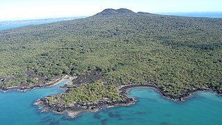
Rangitoto Island is a volcanic island in the Hauraki Gulf near Auckland, New Zealand. The 5.5 km (3.4 mi) wide island is a symmetrical shield volcano cone capped by central scoria cones, reaching a height of 260 m (850 ft). Rangitoto is the youngest and largest of the approximately 50 volcanoes of the Auckland volcanic field, having erupted in two phases about 1450 CE and 1500 CE and covering an area of 2,311 ha. It is separated from the mainland of Auckland's North Shore by the Rangitoto Channel. Since World War II, it has been linked by a causeway to the much older, non-volcanic Motutapu Island.

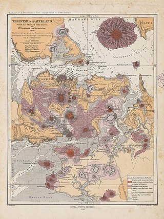
The Auckland volcanic field is an area of monogenetic volcanoes covered by much of the metropolitan area of Auckland, New Zealand's largest city, located in the North Island. The approximately 53 volcanoes in the field have produced a diverse array of maars, tuff rings, scoria cones, and lava flows. With the exception of Rangitoto, no volcano has erupted more than once, but the other eruptions lasted for various periods ranging from a few weeks to several years. Rangitoto erupted several times and recently twice; in an eruption that occurred about 600 years ago, followed by a second eruption approximately 50 years later. The field is fuelled entirely by basaltic magma, unlike the explosive subduction-driven volcanism in the central North Island, such as at Mount Ruapehu and Lake Taupō.

A maar is a broad, low-relief volcanic crater caused by a phreatomagmatic eruption. A maar characteristically fills with water to form a relatively shallow crater lake, which may also be called a maar.

Motukorea or Browns Island is a small New Zealand island, in the Hauraki Gulf north of Musick Point, one of the best preserved volcanoes in the Auckland volcanic field. The age of eruption is about 25,000 years ago, when the Tāmaki Estuary and the Waitemata Harbour were forested river valleys. Due to centuries of cultivation, little native bush remains except on the north-eastern cliffs, leaving the volcanic landforms easily visible. It exhibits the landforms from three styles of eruption. The island consists of one main scoria cone with a deep crater, a small remnant arc of the tuff ring forming the cliffs in the northeast, and the upper portions of lava flows. The area was dry land when the eruptions occurred, but much of the lava is now submerged beneath the sea.

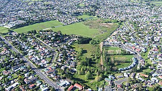
The Panmure Basin, also sometimes known as the Panmure Lagoon, is a tidal estuary within a volcanic crater or maar in New Zealand's Auckland volcanic field. It is located to the south of Panmure town centre.

The volcanism of New Zealand has been responsible for many of the country's geographical features, especially in the North Island and the country's outlying islands.

Onepoto is the name of a volcanic explosion crater on the North Shore in Auckland, New Zealand. It is a part of the Auckland volcanic field. It should not be confused with Onepoto Hill, which is a volcanic feature of the South Auckland volcanic field.

Māngere Lagoon is a lagoon in the Manukau Harbour, New Zealand. It occupies a volcanic crater or maar which is part of the Auckland volcanic field. Oval and about 600m long, it has a small restored scoria island remaining in the centre.

The Auckland Region of New Zealand is built on a basement of greywacke rocks that form many of the islands in the Hauraki Gulf, the Hunua Ranges, and land south of Port Waikato. The Waitākere Ranges in the west are the remains of a large andesitic volcano, and Great Barrier Island was formed by the northern end of the Coromandel Volcanic Zone. The Auckland isthmus and North Shore are composed of Waitemata sandstone and mudstone, and portions of the Northland Allochthon extend as far south as Albany. Little Barrier Island was formed by a relatively isolated andesitic volcano, active around 1 to 3 million years ago.

Ōrākei Basin is a tidal basin and one of the extinct volcanoes in the Auckland volcanic field in the North Island of New Zealand. It has an explosion crater around 700 m (2,300 ft) wide, with a surrounding tuff ring. The present basin is slightly larger than the original maar crater. Sediments in the basin provided the first high-resolution palaeo-environmental reconstruction for northern New Zealand of the last 130,000 years. The basin supports recreational water sports activities for the local population.

Taylors Hill, is a volcano in the Auckland volcanic field. It erupted about 33,000 years ago. Its scoria cone reaches 57 m (187 ft) high.

Pukewairiki located in Highbrook Park is a volcano in the Auckland volcanic field in the North Island of New Zealand.

Robertson Hill is one of the volcanoes in the Auckland volcanic field in New Zealand. It erupted approximately 24,300 years ago. The hill, alongside Māngere Lagoon, Waitomokia, Crater Hill, Kohuora and Pukaki Lagoon, is one of the volcanic features collectively referred to as Nga Tapuwae a Mataoho, referring to the deity in Tāmaki Māori myths who was involved in their creation.

Styaks Swamp is one of the volcanoes in the Auckland volcanic field, found in the suburb of East Tāmaki.

Kohuora, located in the suburb of Papatoetoe, is one of the volcanoes in the Auckland volcanic field in the North Island of New Zealand.
Grafton Volcano is a buried volcano in New Zealand's Auckland volcanic field that underlies much of the Auckland suburb of Grafton. First recognised in 2010, it includes the Outhwaite Park scoria cone that was first mapped by Hochstetter (1864) and inferred by later geologists to be a late phase vent of adjacent Pukekawa Volcano. Borehole drilling and building excavations in the Grafton-Auckland Domain area during the 1990s and 2000s provided new subsurface geological information that allowed geologists to recognise the buried Grafton Volcano.

The Puhinui Craters are located in Auckland's Puhinui Reserve and are part of the Auckland volcanic field in the North Island of New Zealand. They were first recognised as volcanic craters in 2011. A cluster of three small maar craters like these is unique in the Auckland volcanic field. Their ages are unknown but most probably all three erupted during the same eruptive episode. They could have been associated with the eruption of nearby Matukutureia but this is speculation at present.

The South Auckland volcanic field, also known as the Franklin Volcanic Field, is an area of extinct monogenetic volcanoes around Pukekohe, the Franklin area and north-western Waikato, south of the Auckland volcanic field. The field contains at least 82 volcanoes, which erupted between 550,000 and 1,600,000 years ago.
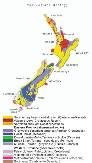
Much of the volcanic activity in the northern portions of the North Island of New Zealand is recent in geological terms and has taken place over the last 30 million years. This is primarily due to the North Island's position on the boundary between the Indo-Australian and Pacific Plates, a part of the Pacific Ring of Fire, and particularly the subduction of the Pacific Plate under the Indo-Australian Plate. The activity has included some of the world's largest eruptions in geologically recent times and has resulted in much of the surface formations of the North Island being volcanic as shown in the map.

Pukekohe Hill is one of the most prominent volcanoes of the South Auckland volcanic field in New Zealand. The shield volcano erupted approximately 550,000 years ago, making it one of the youngest known volcanoes of the field.


