The National Hurricane Center (NHC) is the division of the United States' NOAA/National Weather Service responsible for tracking and predicting tropical weather systems between the Prime Meridian and the 140th meridian west poleward to the 30th parallel north in the northeast Pacific Ocean and the 31st parallel north in the northern Atlantic Ocean. The agency, which is co-located with the Miami branch of the National Weather Service, is situated on the campus of Florida International University in Westchester, Florida.
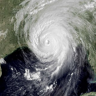
Hurricane Camille was the second most intense tropical cyclone on record to strike the United States and is one of just four Category 5 hurricanes to make landfall in the U.S.

Tropical Storm Allison was a tropical storm that devastated southeast Texas in June of the 2001 Atlantic hurricane season. An arguable example of the "brown ocean effect", Allison lasted unusually long for a June storm, remaining tropical or subtropical for 16 days, most of which was when the storm was over land dumping torrential rainfall. The storm developed from a tropical wave in the northern Gulf of Mexico on June 4, 2001, and struck the upper Texas coast shortly thereafter. It drifted northward through the state, turned back to the south, and re-entered the Gulf of Mexico. The storm continued to the east-northeast, made landfall on Louisiana, then moved across the southeast United States and Mid-Atlantic. Allison was the first storm since Tropical Storm Frances in 1998 to strike the northern Texas coastline.

The 1981 Atlantic hurricane season featured direct or indirect impacts from nearly all of its 12 tropical or subtropical storms. Overall, the season was fairly active, with 22 tropical depressions, 12 of which became a namable storm, while 7 of those reached hurricane status and 3 intensified into major hurricanes. The season officially began on June 1, 1981, and lasted until November 30, 1981. These dates conventionally delimit the period of each year when most tropical cyclones form in the Atlantic basin. However, tropical cyclogenesis can occur before these dates, as demonstrated with the development of two tropical depressions in April and Tropical Storm Arlene in May. At least one tropical cyclone formed in each month between April and November, with the final system, Subtropical Storm Three, becoming extratropical on November 17, 1981.

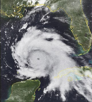
Hurricane Katrina was a devastating Category 5 Atlantic hurricane that resulted in 1,392 fatalities and caused damage estimated between $97.4 billion to $145.5 billion in late August 2005, particularly in the city of New Orleans and its surrounding areas. At the time, it was the costliest tropical cyclone on record, tied now with Hurricane Harvey of 2017. Katrina was the twelfth tropical cyclone, the fifth hurricane, and the third major hurricane of the 2005 Atlantic hurricane season. It was also the fourth-most intense Atlantic hurricane on record to make landfall in the contiguous United States.
Hurricane Katrina's winds and storm surge reached the Mississippi coastline on the morning of August 29, 2005. beginning a two-day path of destruction through central Mississippi; by 10 a.m. CDT on August 29, 2005, the eye of Katrina began traveling up the entire state, only slowing from hurricane-force winds at Meridian near 7 p.m. and entering Tennessee as a tropical storm. Many coastal towns of Mississippi had already been obliterated, in a single night. Hurricane-force winds reached coastal Mississippi by 2 a.m. and lasted over 17 hours, spawning 11 tornadoes and a 28-foot (8.5 m) storm surge flooding 6–12 miles (9.7–19.3 km) inland. Many, unable to evacuate, survived by climbing to attics or rooftops, or swimming to higher buildings and trees. The worst property damage from Katrina occurred in coastal Mississippi, where all towns flooded over 90% in hours, and waves destroyed many historic buildings, with others gutted to the 3rd story. Afterward, 238 people died in Mississippi, and all counties in Mississippi were declared disaster areas, 49 for full federal assistance. Regulations were changed later for emergency centers and casinos. The emergency command centers were moved higher because all 3 coastal centers flooded at 30 ft (9.1 m) above sea level. Casinos were allowed on land rather than limited to floating casino barges as in 2005.

Hurricane Kate was the final in a series of tropical cyclones to impact the United States during 1985. It was the eleventh named storm, seventh hurricane, and third major hurricane of the 1985 Atlantic hurricane season, Kate originated from the interaction of an upper-level trough and tropical wave northeast of Puerto Rico on November 15. Though the system tracked erratically during the first hours of its existence, the intensification of a region of high pressure to the cyclone's north caused Kate to turn westward. A favorable atmospheric pattern allowed the newly developed system to intensify to hurricane intensity on November 16, and further to Category 2 intensity three days later.

Tropical Storm Hanna was a moderately strong tropical storm that affected the Gulf Coast and Southeastern regions of the United States. The ninth tropical cyclone and eighth named storm of the 2002 Atlantic hurricane season, Hanna formed through the complex interaction of a surface trough, a tropical wave, and an upper-level low pressure system, a disturbance in the upper atmosphere. Designated a tropical depression at 0000 UTC on September 12, the storm remained disorganized throughout its duration, though it attained tropical storm status and a peak intensity of 1,001 mbar (29.6 inHg), with winds of 60 miles per hour (100 km/h). Hanna crossed extreme southeastern Louisiana, and made a second landfall along the Alabama–Mississippi border.
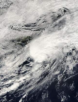
Tropical Storm Helene was a long-lived tropical cyclone that oscillated for ten days between a tropical wave and a 70 mph (110 km/h) tropical storm. It was the twelfth tropical cyclone and eighth tropical storm of the 2000 Atlantic hurricane season, forming on September 15 east of the Windward Islands. After degenerating into a tropical wave, the system produced flooding and mudslides in Puerto Rico. It reformed into a tropical depression on September 19 south of Cuba, and crossed the western portion of the island the next day while on the verge of dissipation. However, it intensified into a tropical storm in the Gulf of Mexico, reaching its peak intensity while approaching the northern Gulf Coast.
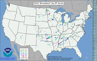
This page documents the tornadoes and tornado outbreaks of 2010. The majority of tornadoes form in the U.S., but they can occur almost anywhere under the right conditions. A lesser number occur outside the U.S., most notably in parts of neighboring southern Canada during the Northern Hemisphere's summer season, but are also known in South America, Europe, Asia, and Australia.

The tornado outbreak of April 22–25, 2010 was a multi-day tornado outbreak across a large portion of the Southern United States, originally starting in the High Plains on April 22, 2010 and continuing through the Southern Plains on April 23, and the Mississippi and Tennessee Valleys on April 24. The most severe activity was on April 24, particularly in Mississippi. The outbreak was responsible for ten tornado-related fatalities on April 24, all in Mississippi from a single supercell that crossed the entire state.

The 2011 Super Outbreak was the largest, costliest, and one of the deadliest tornado outbreaks ever recorded, taking place in the Southern, Midwestern, and Northeastern United States from April 25 to 28, 2011, leaving catastrophic destruction in its wake. Over 175 tornadoes struck Alabama, Mississippi, and Tennessee, which were the most severely damaged states. Other destructive tornadoes occurred in Arkansas, Georgia, Kentucky, Louisiana, New York, and Virginia, with storms also affecting other states in the Southern and Eastern United States. In total, 360 tornadoes were confirmed by NOAA's National Weather Service (NWS) and Government of Canada's Environment Canada in 21 states from Texas to New York to southern Canada. Widespread and destructive tornadoes occurred on each day of the outbreak. April 27 was the most active day, with a record 216 tornadoes touching down that day from midnight to midnight CDT. Four of the tornadoes were rated EF5, which is the highest ranking on the Enhanced Fujita scale; typically these tornadoes are recorded no more than once a year.
Hurricane Debra was a destructive tropical cyclone that developed during the 1959 Atlantic hurricane season. The fifth tropical storm and third hurricane of the season, Debra originated from the interaction of a cold-core low and a tropical wave on July 15. The system was designated a tropical depression on July 23 when it was south of Louisiana and meandered westward while it swiftly intensified into a tropical storm along the Gulf Coast of the United States. A turn towards the northwest became evident as it attained Category 1 hurricane status on the Saffir–Simpson Hurricane Scale the following day while it organized into a developed storm. As the hurricane curved northward at a slow forward speed, strength was maintained as it approached the coast of Texas as a minimal hurricane. It came ashore during the evening of July 24 local time between Freeport and Galveston, Texas. It rapidly weakened into a tropical storm and later a depression as it moved inland, and dissipated on July 28 while it turned northwestward. The remnant moisture later sparked upper-level thunderstorms in late July and early August.

The 1933 Texas tropical storm produced record rainfall in the south-central United States in July of the 1933 Atlantic hurricane season. It was the third storm of the season, developing on July 14 near the Lesser Antilles. While moving westward through the Caribbean Sea, the cyclone passed just south of Jamaica on July 16. The storm dropped heavy rainfall on the island that caused flooding and road washouts. On July 18, the storm struck Belize and later moved across the Yucatán Peninsula. Initially it was believed that the storm continued into Mexico and dissipated while another storm formed to its northeast, but it was discovered in 2012 that the storm followed one continuous track.

Near the end of 2012, a massive storm complex developed that produced both a tornado outbreak and a blizzard across the southern and eastern United States. On Christmas Day 2012, a tornado outbreak occurred across the Southern United States. This severe weather/tornado event affected the United States Gulf Coast and southern East Coast over a two-day span. It occurred in conjunction with a much larger winter storm event that brought blizzard conditions to much of the interior United States. In total, 31 tornadoes were confirmed by the National Weather Service in five states from Texas to North Carolina. All but one of the tornadoes that occurred during the outbreak touched down on December 25, with the other occurring the following day in North Carolina. Two of the tornadoes were destructive enough to be rated EF3 on the Enhanced Fujita Scale. At least 16 people died as a result of the related blizzard, and thousands were without power.

A prolific and deadly winter tornado outbreak struck areas across the Southeast United States between January 21–23, 2017. Lasting just under two days, the outbreak produced a total of 81 tornadoes, cementing its status as the second-largest January tornado outbreak and the third-largest winter tornado outbreak since 1950. Furthermore, it was the largest outbreak on record in Georgia with 42 tornadoes confirmed in the state. The most significant tornadoes were three EF3 tornadoes that heavily damaged or destroyed portions of Hattiesburg, Mississippi, and Albany and Adel, Georgia. A total of 20 people were killed by tornadoes—mainly during the pre-dawn hours of the outbreak—making it the second-deadliest outbreak in January since 1950, behind the 1969 Hazlehurst, Mississippi tornado outbreak that killed 32 people. In addition, the tornado death toll was higher then the entire previous year. In the aftermath of the outbreak, relief organizations assisted in clean-up and aid distribution. Total economic losses from the event reached at least $1.3 billion.
A significant severe weather and tornado outbreak affected the Southern United States between December 16–17, 2019. Discrete supercells developed in the early morning on December 16 and moved northeast, spawning multiple strong, long-tracked tornadoes in cities such as Alexandria and in Laurel before congealing into an eastward-moving squall line. During the outbreak, the National Weather Service issued several PDS tornado warnings as well as a rare tornado emergency for Alexandria. In addition to this, the Storm Prediction Center issued six tornado watches for the outbreak. The event happened to take place on the same date of another outbreak in a similar area 19 years earlier.

A widespread and deadly tornado outbreak affected the Southeastern United States on Easter Sunday and Monday, April 12–13, 2020. Several tornadoes were responsible for prompting tornado emergencies, including the first one to be issued by the National Weather Service in Charleston, South Carolina. A large squall line formed and tracked through the mid-Atlantic on April 13, prompting more tornado warnings and watches. A total of 15 watches were produced during the course of the event, two of which were designated Particularly Dangerous Situations.
A significant tornado outbreak sequence took place from March 24–28, 2021 in the Southern United States just one week after another outbreak affected similar regions. There were 43 tornadoes confirmed across 11 states, with the bulk of activity primarily on March 25, which resulted in the Storm Prediction Center (SPC) issuing its second high-risk outlook for the month of March, as well as the second high-risk outlook for 2021. Several intense tornadoes touched down on that day, including ones that prompted the issuance of rare tornado emergencies near Hoover, Alabama, Brent and Centreville, Alabama, and in the Newnan, Georgia area. March 27 also saw widespread tornado activity mainly across East Texas, Southern Arkansas, Louisiana, and Western Tennessee with several strong tornadoes touching down. Scattered to widespread wind and hail damage occurred throughout the outbreak sequence, and repeated rounds of heavy rain caused widespread severe flash and river flooding across much of Tennessee.

Hurricane Ida generated a tornado outbreak as it traversed the Southeastern, Mid-Atlantic, and Northeastern United States. Thirty-five confirmed tornadoes touched down from Mississippi to Massachusetts; one person was killed in Upper Dublin Township, Pennsylvania, and several people were injured in Alabama, New Jersey, and Pennsylvania. The most active and destructive part of the outbreak occurred during the afternoon of September 1, when several strong tornadoes struck Maryland, New Jersey, and Pennsylvania, including an EF3 tornado which impacted Mullica Hill, New Jersey.