
The 1966 Atlantic hurricane season saw the Weather Bureau office in Miami, Florida, be designated as the National Hurricane Center (NHC) and assume responsibility of tropical cyclone forecasting in the basin. The season officially began on June 1, and lasted until November 30. These dates conventionally delimit the period of each year when most tropical cyclones form in the Atlantic basin. It was an above-average season in terms of tropical storms, with a total of 15. The first system, Hurricane Alma, developed over eastern Nicaragua on June 4 and became a rare major hurricane in the month of June. Alma brought severe flooding to Honduras and later to Cuba, but caused relatively minor impact in the Southeastern United States. Alma resulted in 90 deaths and about $210 million (1966 USD) in damage.
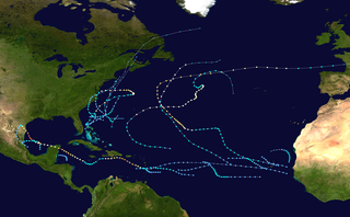
The 1967 Atlantic hurricane season was an active Atlantic hurricane season overall, producing 13 nameable storms, of which 6 strengthened into hurricanes. The season officially began on June 1, 1967, and lasted until November 30, 1967. These dates, adopted by convention, historically describe the period in each year when most tropical cyclogenesis occurs in the Atlantic Ocean. The season's first system, Tropical Depression One, formed on June 10, and the last, Tropical Storm Heidi, lost tropical characteristics on November 2.

The 1975 Atlantic hurricane season was a near average hurricane season with nine named storms forming, of which six became hurricanes. Three of those six became major hurricanes, which are Category 3 or higher systems on the Saffir–Simpson scale. The season officially began on June 1 and lasted until November 30. These dates conventionally delimit the period of each year when most tropical cyclones form in the Atlantic Ocean.

The 1980 Atlantic hurricane season featured nine hurricanes, the most since 1969. This hurricane season was fairly active, with sixteen tropical cyclones forming, eleven of which strengthened into named tropical storms. The season officially began on June 1, 1980, and lasted until November 30, 1980. It was the first time since the 1971 season that there were no active tropical cyclones in the Atlantic basin during the month of June. The season occurred during an ENSO-neutral phase, having neither an El Niño nor a La Niña.
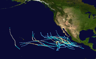
The 1985 Pacific hurricane season is the third-most active Pacific hurricane season on record. It officially started on May 15, 1985, in the eastern Pacific, and on June 1, 1985, in the central Pacific, and lasted until November 30, 1985. These dates conventionally delimit the period of each year when most tropical cyclones form in the northeastern Pacific Ocean. At the time, the 1985 season was the most active on record in the eastern north Pacific, with 28 tropical cyclones forming. Of those, 24 were named, 13 reached hurricane intensity, and 8 became major hurricanes by attaining Category 3 status or higher on the Saffir–Simpson scale. At that time, the 24 named storms was a record; however, this record was broken seven years later in 1992, and was therefore recognized as the second busiest season within the basin, until it was surpassed exactly thirty years later by the 2015 season.

The 1983 Pacific hurricane season was the longest season ever recorded at that time. It was a very active Pacific hurricane season. The season started on May 15, 1983 in the eastern Pacific, and on June 1, 1983 in the central Pacific, and lasted until November 30, 1983. These dates conventionally delimit the period of each year when most tropical cyclones form in the northeastern Pacific Ocean. During the 1983 season, there were 20 named storms, which was slightly less than the previous season. Furthermore, twelve of those storms became hurricanes. And eight of the storms reached major hurricane status, or Category 3 or higher on the Saffir–Simpson hurricane wind scale (SSHWS). The decaying 1982–83 El Niño event likely contributed to this level of activity. That same El Niño influenced a very quiet Atlantic hurricane season.

The 1992 Pacific typhoon season was the fourth consecutive above-average season, producing 31 tropical storms, 16 typhoons and five super typhoons. It had no official bounds; it ran year-round in 1992. Despite this, most tropical cyclones tend to form in the northwestern Pacific Ocean between May and November. These dates conventionally delimit the period of each year when most tropical cyclones form in the northwestern Pacific Ocean.

The 1988 Pacific typhoon season was a very active season in terms of named storms, though it only featured 11 typhoons and 1 super typhoon. It had no official bounds; it ran year-round in 1988, but most tropical cyclones formed between May and November. Tropical storms that formed in the entire west Pacific basin were assigned a name by the Joint Typhoon Warning Center. Tropical depressions that enter or form in the Philippine area of responsibility are assigned a name by the Philippine Atmospheric, Geophysical and Astronomical Services Administration or PAGASA. This can often result in the same storm having two names.

The 2007 Pacific hurricane season was a well below-average Pacific hurricane season, featuring only one major hurricane. The season officially started on May 15 in the eastern Pacific and on June 1 in the central Pacific, and ended on November 30; these dates conventionally delimit the period during which most tropical cyclones form in the region. The first tropical cyclone of the season, Alvin, developed on May 27, while the final system of the year, Kiko, dissipated on October 23. Due to unusually strong wind shear, activity fell short of the long-term average, with a total of 11 named storms, 4 hurricanes, and 1 major hurricane. At the time, 2007 featured the second-lowest value of the Accumulated cyclone energy (ACE) index since reliable records began in 1971. Two tropical cyclones – Cosme and Flossie – crossed into the central Pacific basin during the year, activity below the average of 4 to 5 systems.

The 1969 Pacific hurricane season had below average tropical cyclone activity, with only ten named storms forming; most of these storms never approached land. Only four named storms reached hurricane strength, of which none became a major hurricane. It officially started on May 15, 1969, in the eastern Pacific Ocean, and ended on November 30, 1969. These dates conventionally delimit the period of each year when most tropical cyclones form east of this region of the Pacific. The first named storm of the season, Tropical Storm Ava, developed on July 1, and the last, Hurricane Jennifer, dissipated on October 23. At the time, Ava was the latest forming first named storm in any Eastern Pacific season on record.

Hurricane Gabrielle was a powerful tropical cyclone that caused nine fatalities in the United States and Canada, despite remaining hundreds of miles offshore. The tenth tropical cyclone, seventh named storm, fifth hurricane, and first major hurricane of the 1989 Atlantic hurricane season, Gabrielle developed on August 30 from a tropical wave near the west coast of Africa. Under favorable conditions, the depression intensified and became Tropical Storm Gabrielle early on the following day. Rapid strengthening occurred thereafter, with Gabrielle reaching hurricane intensity early on September 1. After becoming a hurricane, further intensification was steady, though by September 5, Gabrielle peaked as a moderate Category 4 hurricane. On the following day, Gabrielle began to slowly level-off in intensity, while gradually curving northward. After weakening to a Category 2 hurricane, the storm passed east of Bermuda on September 8.

The 1968 Pacific hurricane season ties the record for having the most active August in terms of tropical storms. It officially started on May 15, 1968, in the eastern Pacific and June 1 in the central Pacific and lasted until November 30, 1968. These dates conventionally delimit the period of each year when most tropical cyclones form in the northeastern Pacific Ocean.

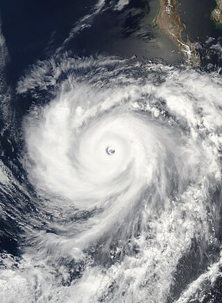
Hurricane Guillermo was the ninth-most intense Pacific hurricane on record, attaining peak winds of 160 mph (260 km/h) and a barometric pressure of 919 hPa (27.14 inHg). Forming out of a tropical wave on July 30, 1997, roughly 345 mi (555 km) south of Salina Cruz, Mexico, Guillermo tracked in a steady west-northwestward direction while intensifying. The system reached hurricane status by August 1 before undergoing rapid intensification the following day. At the end of this phase, the storm attained its peak intensity as a powerful Category 5 hurricane. The storm began to weaken during the afternoon of August 5 and was downgraded to a tropical storm on August 8. Once entering the Central Pacific Hurricane Center's area of responsibility, Guillermo briefly weakened to a tropical depression before re-attaining tropical storm status. On August 15, the storm reached an unusually high latitude of 41.8°N before transitioning into an extratropical cyclone. The remnants persisted for more than a week as they tracked towards the northeast and later south and east before being absorbed by a larger extratropical system off the coast of California on August 24.
Hurricane Hernan was the second of three Category 5 hurricanes during the 2002 Pacific hurricane season. The twelfth tropical cyclone, tenth named storm and sixth hurricane of the season, Hernan originated from a tropical wave that formed in the Atlantic Ocean and crossed to the Pacific Ocean. The wave spawned a low-pressure area which organized into a tropical depression on August 30, a tropical storm on August 31 and a hurricane later that day. Hernan rapidly intensified and reached peak intensity as a Category 5 storm on the Saffir–Simpson hurricane scale. Proceeding northwest, it maintained this strength for eight hours, but on September 2 it entered cooler waters and began to weaken. By September 6 it had degenerated into a remnant area of low pressure.

Hurricane Pauline was the deadliest hurricane of the 1968 Pacific hurricane season. Forming from a disturbance in the Intertropical Convergence Zone on September 26 and becoming a tropical storm on September 29, the hurricane strengthened to a peak of 85 mph (137 km/h) as a Category 1 hurricane on the Saffir-Simpson Hurricane Scale on September 30 before making landfall just east of La Paz, Baja California Sur, near Ciudad Constitución in Mexico, exiting over the Gulf of California. Before making a second landfall on the state of Sonora on October 3, Pauline lost tropical characteristics. The storm continued inland, passing directly over Ciudad Obregón before dissipating south-southeast of Sierra Vista, Arizona.

Typhoon Roy, known in the Philippines as Typhoon Asiang, was the second-most intense January tropical cyclone on record in the Western Pacific basin. Forming out of an area of disturbed weather on January 7, 1988, Roy quickly intensified as it moved through the Marshall Islands. By January 9, the storm intensified into a typhoon and attained its peak intensity the following day. At its peak, sustained winds reached 215 km/h (135 mph). Slight weakening took place before the storm moved through the Mariana Islands. Continuing westward, the system eventually struck the Philippines as a minimal typhoon before dissipating over the South China Sea on January 19.

Hurricane Estelle was a powerful tropical cyclone that caused minor damage and two deaths in Hawaii in July 1986. Estelle was the sixth tropical cyclone, fifth named storm, third hurricane, and first major hurricane of the above-average 1986 Pacific hurricane season. It formed as a tropical depression formed well southwest of the Baja California Peninsula on July 16, and strengthened into a tropical storm within 24 hours. Located within a favorable environment, Estelle intensified into a hurricane on July 18. It attained major hurricane status two days later. After peaking in intensity at Category 4 strength, Estelle slowly weakened. By July 24, Estelle was no longer a hurricane while passing south of Hawaii. It completely dissipated on July 26 after further deteriorating to a tropical depression. The arrival of the hurricane prompted a hurricane watch for Hawaii, and 200 people evacuated from their homes. Hurricane Estelle produced high waves offshore Hawaii, causing $2 million in damage and two deaths. The remnants of the storm also produced intermittent showers across the state, though there was no major damage.

Typhoon Andy, known in the Philippines as Typhoon Iliang, was an intense tropical cyclone that made landfall in Taiwan. Andy formed along the northern edge of the monsoon trough south of Guam on July 22, 1982. It became a tropical storm the next day, although this system was initially poorly organized. Andy moved steadily west during the first few days of its life. After looping south of Guam, the cyclone moved northwest and strengthened. Andy turned westward near the 18th parallel on July 25. The system became a strong typhoon for a prolonged period on July 27 and July 28 while attaining a peak intensity of 185 km/h (115 mph). However, the typhoon struck Southern Taiwan on July 29. Continuing westward through the Formosa Strait, the storm made its final landfall in southern China on July 30 and dissipated inland two days later.

Hurricane Uleki, also referred as Typhoon Uleki, was a long-lived tropical cyclone in August–September 1988 that had minimal effects on land. Originating from a disturbance in the Intertropical Convergence Zone in late-August, Uleki was identified as a tropical depression well to the southeast of Hawaii on August 28. Steady organization ensued as it moved west, becoming a tropical storm on August 30 and a hurricane on August 31. Rapid intensification took place thereafter and the storm reached its peak intensity on September 2 as a Category 3 on the Saffir–Simpson hurricane wind scale. hurricane hunters investigating the cyclone found peak winds of 125 mph (201 km/h) and a barometric pressure of 957 mbar. Thereafter, Uleki stalled for two days to the southwest of Hawaii, resulting in heavy surf across the state. The dangerous swells killed two people on Oahu.

Typhoon Irving, known in the Philippines as Tropical Storm Ruping, was a mid-season tropical cyclone that affected the Philippines and China during September 1982. An area of disturbed weather developed within the monsoon trough during early September 1982 near Guam. Following an increase in organization, a tropical depression developed on the morning of September 5. Later that day, the depression intensified into Tropical Storm Irving. Irving tracked westward, nearly becoming a typhoon before hitting the central Philippines. There, Irving uprooted trees, downed power and telephone lines, triggered landslides, and forced the cancellation of several domestic airline flights. Irving damaged 7,890 houses in Albay and Sorsogon provinces alone, resulting in 138,500 people homeless. Nation-wide, 65 people were killed, 26 others were hurt, and 29 were rendered missing. A total of 44,383 families or 248,040 residents sought shelter. Moreover, 18,488 homes were damaged and 5,599 others were demolished. Damage in the country was assessed at US$23.3 million, including US$14.2 million in crops. While crossing the island chain, Irving turned northwestward. After entering the South China Sea, Irving continued generally northwest, and became a typhoon on September 11. After developing a well-defined eye, Irving attained its peak intensity of 160 km/h (100 mph) the following day. Land interaction with Hainan Island resulted in a weakening trend, and Irving was downgraded to a tropical storm before striking the southern coast of China on September 15. Across the Leizhou Peninsula, 90% of homes were damaged. Onshore, Irving rapidly weakened and the storm dissipated on September 16.


