The 1981 Pacific hurricane season was a slightly below average Pacific hurricane season. The season officially started on May 15 in the eastern Pacific basin and June 1 in the central Pacific basin. Both basins' seasons ended on November 30; these dates conventionally delimit the period during which most tropical cyclones form in the northeastern Pacific Ocean. The first tropical cyclone of the season was designated on May 30, and the final storm of the season, Hurricane Otis, dissipated on October 30. The season produced fifteen named storms and a total of eight hurricanes, which was near normal. However, the total of one major hurricane was below the average of three.

The 1976 Pacific hurricane season was a very deadly and costly season. Hurricanes Kathleen, Liza, and Madeline were the most notable storms this year. Hurricane Kathleen caused death and destruction in California and Arizona due to flooding. Hurricane Liza was the deadliest storm of the season when it killed over 600 people in Mexico. Hurricane Madeline is notable for being one of the most intense Pacific hurricanes at landfall.

The 1971 Pacific hurricane season began on May 15, 1971 in the eastern Pacific, and on June 1, 1971 in the Central Pacific ; both ended on November 30, 1971. These dates, adopted by convention, historically describe the period in each year when most tropical cyclogenesis occurs in these regions of the Pacific. It was the first year that continuous Weather satellite coverage existed over the entire Central Pacific. As such, this season is often viewed as the start year for modern reliable tropical cyclone data in the Pacific Ocean.
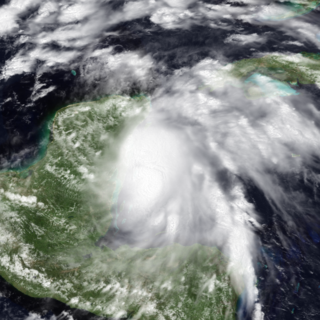
Hurricane Dolly caused flooding throughout Mexico in August 1996. The fourth named storm and third hurricane of the season, Dolly developed from a tropical wave to the west-southwest of Jamaica on August 19. Initially a tropical depression, the system strengthened into a tropical storm about twelve hours later. Dolly headed westward and intensified into a Category 1 hurricane late on August 20. It then made landfall near Chetumal, Quintana Roo. The system weakened to a tropical depression on August 21. Later that day or early on August 22, Dolly emerged into the Bay of Campeche and quickly re-strengthened into a tropical storm. The storm deepened further and was upgraded to a hurricane again by midday on August 23; Dolly simultaneously peaked with winds of 80 mph (130 km/h). Around that time, it struck between Tuxpan, Veracruz, and Tampico, Tamaulipas. Dolly quickly weakened to a tropical depression early on August 24, but remained intact while crossing Mexico and dissipated over the eastern Pacific Ocean on August 25.
Hurricane Lane was a powerful tropical cyclone which is tied as the ninth-strongest landfalling Pacific hurricane on record. The thirteenth named storm, ninth hurricane, and sixth major hurricane of the 2006 Pacific hurricane season, Lane developed on September 13 from a tropical wave to the south of Mexico. It moved northwestward, parallel to the coast of Mexico, and steadily intensified in an area conducive to further strengthening. After turning to the northeast, Lane attained peak winds of 125 mph (201 km/h), and made landfall in the state of Sinaloa at peak strength. It rapidly weakened and dissipated on September 17, and later brought precipitation to southern part of the U.S. state of Texas.

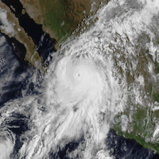
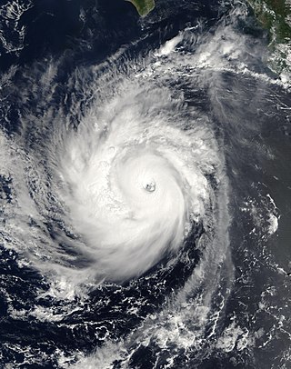
Hurricane Tico is one of four major hurricanes to ever strike Mazatlan and one of the strongest landfalling Pacific hurricanes on record. Tico was the twenty-third tropical cyclone, nineteenth named storm, eleventh hurricane, and eighth major hurricane of the 1983 Pacific hurricane season. The origins of Hurricane Tico were a weak tropical disturbance that crossed Costa Rica into the Pacific Ocean on October 7, 1983. Over warm waters, the system was sufficiently organized to be declared Tropical Depression Twenty-One on October 11, about 575 mi (925 km) south of Acapulco. On October 12 it turned sharply northward; the depression was upgraded to Tropical Storm Tico on October 13. Tropical Storm Tico continued to intensify. Two days after becoming a tropical storm, Tico strengthened further to attain hurricane status. Early on October 19, it reached peak winds of 130 mph (210 km/h). It weakened slightly as it approached the coast, and at about 1500 UTC that day Tico made landfall near Mazatlán with winds of 125 mph (205 km/h). The remains were tracked into the Mid-Atlantic States for five more days.

The 1968 Pacific hurricane season ties the record for having the most active August in terms of tropical storms. It officially started on May 15, 1968, in the eastern Pacific and June 1 in the central Pacific and lasted until November 30, 1968. These dates conventionally delimit the period of each year when most tropical cyclones form in the northeastern Pacific Ocean.
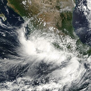
Tropical Storm Norman was a tropical cyclone that hit Mexico in September 2000. The sixteenth cyclone and fourteenth named storm of the 2000 Pacific hurricane season, Norman originated in a tropical wave that emerged from the coast of Africa on September 4, and moved westward across the Atlantic Ocean; the wave entered the Pacific on September 16. The disturbance organized into a tropical depression on early on September 20, and later that day the storm reached its peak intensity of 50 mph (80 km/h), and subsequently made landfall to the west of Lázaro Cárdenas, Michoacán. After weakening to a tropical depression over land, the storm re-emerged over open waters, and made a second landfall before dissipating shortly thereafter. The storm produced heavy rain that resulted in flooding and mudslides, killing about nine people.
Hurricane Norbert is tied with Hurricane Jimena as the strongest tropical cyclone to strike the west coast of Baja California Sur in recorded history. The fifteenth named storm, seventh hurricane, and second major hurricane of the 2008 hurricane season, Norbert originated as a tropical depression from a tropical wave south of Acapulco on October 3. Strong wind shear initially prevented much development, but the cyclone encountered a more favorable environment as it moved westward. On October 5, the National Hurricane Center (NHC) upgraded the depression to Tropical Storm Norbert, and the system intensified further to attain hurricane intensity by October 6. After undergoing a period of rapid deepening, Norbert reached its peak intensity as a Category 4 on the Saffir–Simpson hurricane wind scale, with maximum sustained winds of 135 mph (217 km/h) and a minimum barometric pressure of 945 mbar. As the cyclone rounded the western periphery of a subtropical ridge over Mexico, it began an eyewall replacement cycle which led to steady weakening. Completing this cycle and briefly reintensifying into a major hurricane, a Category 3 or higher on the Saffir–Simpson hurricane wind scale, Norbert moved ashore Baja California Sur as a Category 2 hurricane late on October 11. After a second landfall at a weaker intensity the following day, the system quickly weakened over land and dissipated that afternoon.

Hurricane Kiko was one of the strongest tropical cyclones on record to have made landfall on Mexico's Baja California peninsula. The eleventh named storm of the 1989 Pacific hurricane season, Kiko formed out of a large mesoscale convective system on August 25. Slowly tracking northwestward, the storm rapidly intensified into a hurricane early the next day. Strengthening continued until early August 27, when Kiko reached its peak intensity with winds of 120 mph (190 km/h). The storm turned west at this time, and at around 0600 UTC, the storm made landfall near Punta Arena, Mexico at the southern tip of Baja California Sur. The hurricane rapidly weakened into a tropical storm later that day and further into a tropical depression by August 28, shortly after entering the Pacific Ocean. The depression persisted for another day while tracking southward, before being absorbed by nearby Tropical Storm Lorena. Though Kiko made landfall as a Category 3 hurricane, its impact was relatively minor. Press reports indicated that 20 homes were destroyed and numerous highways were flooded by torrential rains.

Hurricane Olivia was considered the worst hurricane to hit Mazatlán, Sinaloa since 1943, in addition to being the strongest landfalling and costliest hurricane of the 1975 Pacific hurricane season. Olivia formed on October 22 to the south of Mexico, quickly intensifying into a tropical storm. The storm moved northwestward initially, followed by a northeast turn. On October 23, Olivia attained hurricane status, and the next day reached Category 3 intensity on the Saffir-Simpson scale just before moving ashore Mazatlán in northwest Mexico. Olivia destroyed 7,000 houses in the region, leaving 30,000 people homeless, and damage totaled $20 million. The hurricane killed 30 people, 20 of them from drowning in shrimp boats.

Tropical Depression One-E was the earliest tropical cyclone in the calendar year to impact the Mexican state of Sinaloa ever recorded. The first system of the 2009 Pacific hurricane season, One-E formed out of an area of disturbed weather on June 18, 2009, and initially tracked slowly northwards. Throughout the day, convection developed around the center of circulation and the system was anticipated to become a tropical storm. Late on June 18, the National Hurricane Center noted that the system was on the verge of becoming a tropical storm; it would have been named Andres had this occurred. However, the following day, strong wind shear caused the depression to rapidly degenerate into a trough of low pressure before dissipating off the coast of Sinaloa.

Hurricane Roslyn was the strongest hurricane of the 1986 Pacific hurricane season. The seventeenth and final named storm of the season, Roslyn developed on October 15 to the south of Mexico. Its movement was initially guided by a ridge to its north, and it became a tropical storm on October 16 and a hurricane a day later. The hurricane reached peak winds of 145 mph (233 km/h) on October 19 before weakening and turning to the northeast. Roslyn ultimately moved ashore near Mazatlán, Sinaloa as a minimal hurricane, where it caused minimal damage due to the light population affected. It rapidly dissipated, although the remnants brought precipitation to Texas and other portions of the central and southern United States. There were no fatalities and reported damage was minor.
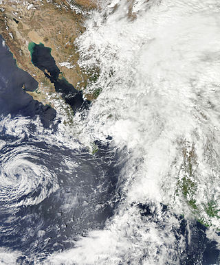
Tropical Storm Rachel was the only tropical cyclone to make landfall during the 1990 Pacific hurricane season. The twenty-fourth tropical depression and eighteenth named storm, Rachel developed on September 27 from a tropical wave southwest of mainland Mexico. After becoming a tropical depression, the system tracked slowly southwestward and eventually curved northwestward. The depression intensified into a tropical storm after three days and was named Rachel by the National Hurricane Center. Rachel continued to steadily strengthen, and peaked as a strong 65 mph (100 km/h) tropical storm on October 2. After attaining peak intensity, Rachel re-curved to make a landfall in southern Baja California Sur and again in the Mexican Mainland on October 3. The storm produced heavy rainfall across northern Mexico and the Southwestern United States. Thousands of people were left homeless and 18 fatalities were reported.

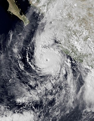
Hurricane Norma was one of the two hurricanes to make landfall during the 1981 Pacific hurricane season. It developed on October 8, strengthening into a tropical storm and later a hurricane. Norma moved slowly to the northwest and strengthened into a Category 3 hurricane on the Saffir–Simpson hurricane scale. The storm recurved and accelerated to the northeast on October 11 and weakened to a Category 2. The next day, Norma made landfall near Mazatlán on October 12 and soon dissipated. The hurricane's remnants continued northeastward and entered the United States, crossing into central Texas before being absorbed by a frontal system on October 14. Norma caused $24 million in crop damage and one death in Mexico, as well as up to 10 in (250 mm). In Texas, the storm produced flooding rains that killed five people, caused $50 million in damage and caused many tornadoes. Rainfall was also reported as far inland as Kansas.
Tropical Storm Norman was the fourteenth tropical cyclone of the 2012 Pacific hurricane season that brought minor flooding to western Mexico and record rainfall to areas of Texas in September 2012. Originating from a disturbance near the southern tip of Baja California, it soon moved north and developed into a tropical cyclone on September 28. Upon developing into one, Norman attained its peak intensity with maximum sustained winds of 50 mph (85 km/h). Heading northward into the Gulf of California, the storm began to weaken later that day due to southwesterly wind shear and land interaction. Norman curved northwestward and weakened to a tropical depression early on September 29. Around that time, it briefly moved inland near Topolobampo, Sinaloa, before re-emerging into the Gulf of California. Later on September 29, Norman degenerated into a remnant low pressure area.
Hurricane Willa was a powerful tropical cyclone that brought torrential rains and destructive winds to southwestern Mexico, particularly the states of Sinaloa and Nayarit, during late October 2018. It was the twenty-fifth tropical cyclone, twenty-second named storm, thirteenth hurricane, tenth major hurricane, and record-tying third Category 5 hurricane of the 2018 Pacific hurricane season. Willa was the first major hurricane to make landfall in the Mexican state of Sinaloa since Lane in 2006.

Hurricane Pamela was a Category 1 Pacific hurricane that caused significant damage across several northwestern and western states of Mexico in October 2021. The sixteenth named storm and seventh hurricane of the 2021 Pacific hurricane season, the storm originated from a tropical wave over the Atlantic basin, over the Caribbean Sea. It then quickly crossed into the Pacific Ocean, where it slowly consolidated, with a low-pressure area forming from the wave on October 9. Environmental conditions in the area were proved favorable for tropical cyclogenesis and developed into Tropical Depression Sixteen-E on the next day. It then organized further into Tropical Storm Pamela on that night. Despite wind shear and dry air affecting the cyclone, Pamela continued to strengthen and became a hurricane on October 12 before weakening back to a tropical storm as it continued to succumb onto these factors. However, as the system turned towards the coast of Mexico, Pamela restrengthened to a low-end hurricane before making landfall over Estacion Dimas, Sinaloa on 15:00 UTC on October 13 before rapidly weakening inland. It then dissipated over Coahuila on the early hours on the next day.

Hurricane Orlene was a powerful tropical cyclone that caused minor damage to the Pacific coast of Mexico in October 2022. The cyclone was the sixteenth named storm, ninth hurricane, and third major hurricane of the 2022 Pacific hurricane season. Orlene originated from a low-pressure area off the coast of Mexico. Moving towards the north, Orlene gradually strengthened, becoming a hurricane on October 1 and reaching its peak intensity the following day with winds of 130 mph (215 km/h). Orlene made landfall just north of the Nayarit and Sinaloa border, with winds of 85 mph (140 km/h). Soon afterward, Orlene rapidly weakened and became a tropical depression, eventually dissipating over the Sierra Madre Occidental late on October 4.


