
The 2001 Atlantic hurricane season was a fairly active Atlantic hurricane season that produced 17 tropical cyclones, 15 named storms, nine hurricanes, and four major hurricanes. The season officially lasted from June 1, 2001, to November 30, 2001, dates which by convention limit the period of each year when tropical cyclones tend to form in the Atlantic Ocean basin. The season began with Tropical Storm Allison on June 4, and ended with Hurricane Olga, which dissipated on December 6.

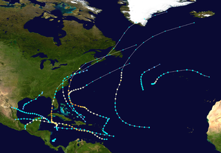
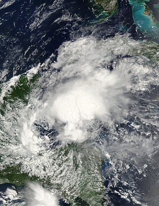
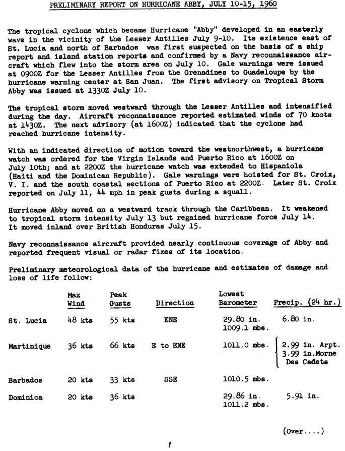
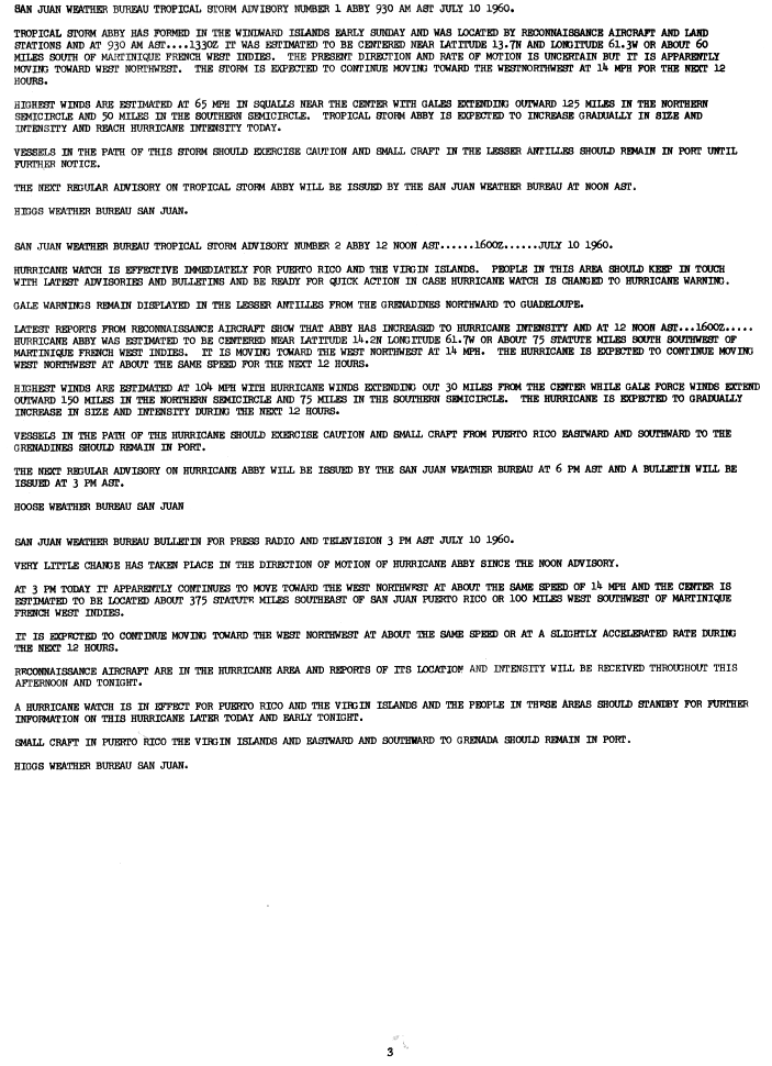
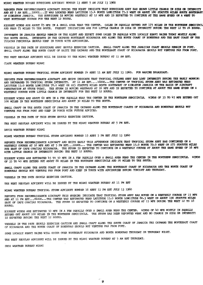
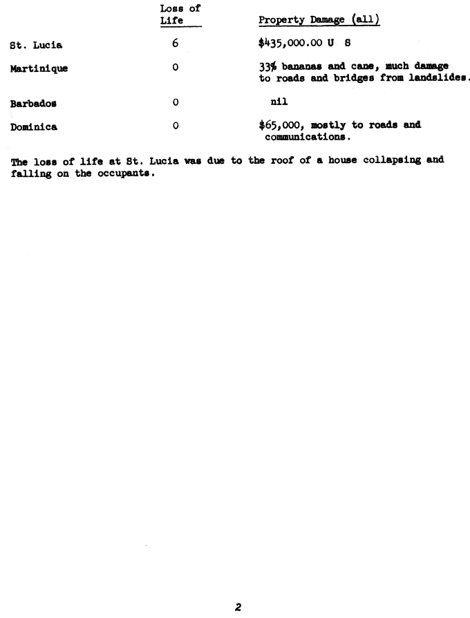
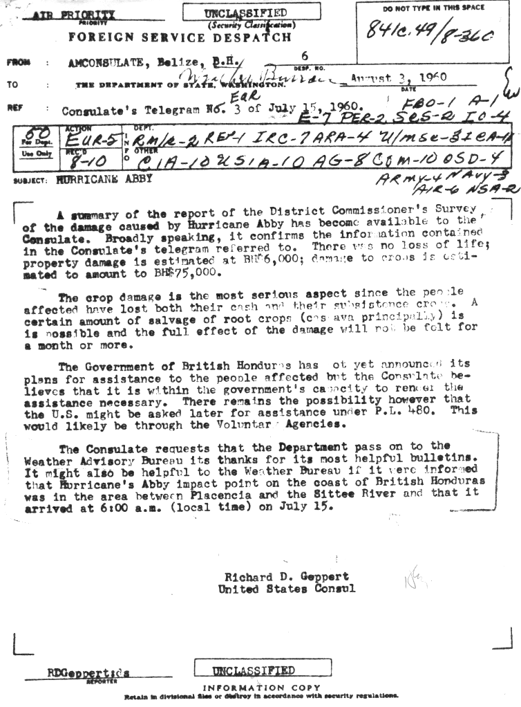
The 1960 Atlantic hurricane season was the least active season since 1952. The season officially began on June 15, and lasted until November 15. These dates conventionally delimit the period of each year when most tropical cyclones form in the Atlantic basin. The first system, an unnamed storm, developed in the Bay of Campeche on June 22. It brought severe local flooding to southeastern Texas and was considered the worst disaster in some towns since a Hurricane in 1945. The unnamed storm moved across the United States for almost a week before dissipating on June 29. In July, Hurricane Abby resulted in minor damage in the Leeward Islands, before impacting a few Central American counties — the remnants of the storm would go on to form Hurricane Celeste in the East Pacific. Later that month, Tropical Storm Brenda caused flooding across much of the East Coast of the United States. The next storm, Hurricane Cleo, caused no known impact, despite its close proximity to land.

The 1964 Atlantic hurricane season featured the highest number of U.S.-landfalling hurricanes since 1933. The season officially began on June 15, and lasted until November 30. These dates conventionally delimit the period of each year when most tropical cyclones form in the Atlantic basin. The season was above average, with thirteen named storms, seven hurricanes, and five major hurricanes. The first system, an unnamed tropical storm, developed on June 2, almost two weeks before the official start of the season. Striking Florida on June 6, the storm brought localized flooding to portions of Cuba and the Southeastern United States, leaving about $1 million in damage. The next storm, also unnamed, developed near the end of July; it did not impact land.

The 1966 Atlantic hurricane season saw the Weather Bureau office in Miami, Florida, be designated as the National Hurricane Center (NHC) and assume responsibility of tropical cyclone forecasting in the basin. The season officially began on June 1, and lasted until November 30. These dates conventionally delimit the period of each year when most tropical cyclones form in the Atlantic basin. It was an above-average season in terms of tropical storms, with a total of 15. The first system, Hurricane Alma, developed over eastern Nicaragua on June 4 and became the most recent major hurricane in the month of June. Alma brought severe flooding to Honduras and later to Cuba, but caused relatively minor impact in the Southeastern United States. Alma resulted in 91 deaths and about $210.1 million (1966 USD) in damage.

The 1968 Atlantic hurricane season was a below average hurricane season during which only seven named storms developed. The season officially began on June 1 and lasted until November 30, dates which conventionally delimit the period of each year when most tropical cyclones form in the Atlantic basin. Of the named storms, five strengthened into hurricanes; none however intensified into a major hurricane. Only four other seasons since the start of the satellite era—1972, 1986, 1994, and 2013—did not feature a major hurricane. The first system, Hurricane Abby, developed in the northwestern Caribbean on June 1. Abby moved northward and struck Cuba, bringing heavy rainfall and flooding to western portions of the island. Making landfall in Florida on June 4, Abby caused flooding and spawned four tornadoes, but left behind little damage. Overall, the hurricane resulted in six deaths and about $450,000 (1968 USD) in damage. In late June, Tropical Storm Candy brought minor flooding and spawned several tornadoes across portions of the Southern United States. Overall damage from the cyclone reached approximately $2.7 million. 1968 featured two simultaneously active tropical storms during the month of June, a phenomenon that would not occur again until 2023.

The 1971 Atlantic hurricane season was fairly active with several notable storms. Hurricane Edith, the strongest of the season, was a Category 5 on the Saffir-Simpson scale, the highest category on the scale, even though it was the least intense for that category on record, at 943 mbar. It struck Nicaragua at peak intensity, killing dozens, and later hit southern Louisiana. Until 2003, Hurricane Ginger held the record for the longest known duration of a North Atlantic tropical cyclone, lasting 27.25 days from early September to early October; it is currently the second longest-lasting Atlantic hurricane. Ginger moved ashore in North Carolina, producing heavy rains and damaging winds. An unnamed storm in August attained hurricane status further north than any other Atlantic hurricane. On 11 September, seven tropical cyclones were active at the same time, the record for the Atlantic basin.

The 1990 Atlantic hurricane season was the most active Atlantic hurricane season since 1969, with a total of 14 named storms. The season also featured eight hurricanes, one of which intensified into a major hurricane. It officially began on June 1, 1990, and lasted until November 30, 1990. These dates conventionally delimit the period of each year when most tropical cyclones form in the Atlantic basin. However, tropical cyclogenesis can occur prior to the start of the season, as demonstrated with Tropical Depression One, which formed in the Caribbean Sea on May 24.

The 1951 Atlantic hurricane season was the first hurricane season in which tropical cyclones were officially named by the United States Weather Bureau. The season officially started on June 15, when the United States Weather Bureau began its daily monitoring for tropical cyclone activity; the season officially ended on November 15. It was the first year since 1937 in which no hurricanes made landfall on the United States; as Hurricane How was the only tropical storm to hit the nation, the season had the least tropical cyclone damage in the United States since the 1939 season. As in the 1950 season, names from the Joint Army/Navy Phonetic Alphabet were used to name storms this season.

The 1945 Atlantic hurricane season produced multiple landfalling tropical cyclones. It officially began on June 16 and lasted until October 31, dates delimiting the period when a majority of storms were perceived to form in the Atlantic Ocean. A total of 11 systems were documented, including a late-season cyclone retroactively added a decade later. Five of the eleven systems intensified into hurricanes, and two further attained their peaks as major hurricanes. Activity began with the formation of a tropical storm in the Caribbean on June 20, which then made landfalls in Florida and North Carolina at hurricane intensity, causing one death and at least $75,000 in damage. In late August, a Category 3 hurricane on the modern-day Saffir–Simpson hurricane wind scale struck the Texas coastline, with 3 deaths and $20.1 million in damage. The most powerful hurricane of the season, reaching Category 4 intensity, wrought severe damage throughout the Bahamas and East Coast of the United States, namely Florida, in mid-September; 26 people were killed and damage reached $60 million. A hurricane moved ashore the coastline of Belize in early October, causing one death, while the final cyclone of the year resulted in 5 deaths and $2 million in damage across Cuba and the Bahamas two weeks later. Overall, 36 people were killed and damage reached at least $82.85 million.
The 1944 Atlantic hurricane season featured the first instance of upper-tropospheric observations from radiosonde – a telemetry device used to record weather data in the atmosphere – being incorporated into tropical cyclone track forecasting for a fully developed hurricane. The season officially began on June 15, 1944, and ended on November 15, 1944. These dates describe the period of each year when most tropical cyclones form in the Atlantic basin. The season's first cyclone developed on July 13, while the final system became an extratropical cyclone by November 13. The season was fairly active season, with 14 tropical storms, 8 hurricanes, and 3 major hurricanes. In real-time, forecasters at the Weather Bureau tracked eleven tropical storms, but later analysis uncovered evidence of three previously unclassified tropical storms.

The 1942 Atlantic hurricane season was one of seven seasons to feature multiple hurricane landfalls in Texas. The season officially lasted from June 16, 1942, to October 31, 1942. These dates conventionally delimit the period of each year when most tropical cyclones form in the Atlantic basin. A total of 11 tropical storms from 1943 are listed in the Atlantic hurricane database, with two additional tropical depressions. The first system of the year, a tropical depression, developed over the central Gulf of Mexico on June 3, while the last system, the Belize hurricane, dissipated over the Yucatán Peninsula on November 11. After the depression dissipated on June 3, the season remained dormant until the next system developed two months later. In mid-August, a hurricane struck Texas, causing about $790,000 (1942 USD) in damage.

The 1931 Atlantic hurricane season was an active hurricane season, with a total of 13 storms recorded, which was the most since 1916. However, only three of them intensified into hurricanes and just one reached major hurricane intensity, which is Category 3 or higher on the modern-day Saffir–Simpson scale. Nine of the tropical cyclones were identified in real-time, while evidence of the existence of four other tropical cyclones was uncovered by the Atlantic hurricane reanalysis project in 2012 and added to the Atlantic hurricane database. Additionally, two of the tropical storms were upgraded to hurricane status as part of the reanalysis.

The 1918 Atlantic hurricane season was inactive, with a total of six tropical storms developing, four of which intensified into hurricanes. Two of the season's hurricanes made Landfall in the United States, and one became a major hurricane, which is Category 3 or higher on the modern-day Saffir–Simpson scale. Additionally, there were four suspected tropical depressions, including one that began the season on June 19 and one that ended the season when it dissipated on October 19. The early 20th century lacked modern forecasting and documentation, and thus, the hurricane database from these years may be incomplete. Four previously unknown tropical cyclones were identified using records, including historical weather maps and ship reports, while information on the known storms was amended.

The 1917 Atlantic hurricane season featured nine known tropical cyclones, four of which became tropical storms. The first system appeared on July 6 east of the Windward Islands. After crossing the islands and traversing the Caribbean Sea, the storm struck Honduras, Belize, and Mexico, before dissipating on July 14. After more than three weeks without tropical cyclogenesis, another tropical storm developed west of Bermuda. As the storm brushed eastern New England, four ships sank near Nantucket, causing 41 fatalities. The same cyclone brought damaging winds to Nova Scotia before transitioning into an extratropical cyclone on August 10.

The 1901 Atlantic hurricane season was the most active season without a major hurricane – tropical cyclones that reach at least Category 3 on the Saffir–Simpson hurricane wind scale – until 2013. The first system was initially observed in the northeastern Caribbean on June 11. The fourteenth and final system transitioned into an extratropical cyclone near Bermuda on November 5. These dates fall within the period with the most tropical cyclone activity in the Atlantic. Eight of the fourteen tropical cyclones existed simultaneously.

Hurricane Greta, later Hurricane Olivia, was one of fourteen named Atlantic hurricanes to cross over Central America into the eastern Pacific while remaining a tropical cyclone. The seventh named storm of the 1978 Atlantic hurricane season, Greta formed from a tropical wave just northwest of Trinidad on September 13, and despite being in a climatologically unfavorable area, gradually intensified while moving west-northwestward. On September 16, it became a hurricane south of Jamaica. Two days later, the well-defined eye approached northeastern Honduras but veered to the northwest. After reaching peak winds of 130 mph (210 km/h) that day, Greta weakened while paralleling the northern Honduras coast just offshore. On September 19, it made landfall on Belize near Dangriga and quickly weakened into a tropical depression while crossing Guatemala and southeastern Mexico. After entering the eastern Pacific, the system re-intensified into a hurricane and was renamed Olivia, the eighteenth named storm of the 1978 Pacific hurricane season which weakened before landfall and dissipated over Chiapas on September 23.
Tropical Storm Chantal was a North Atlantic tropical cyclone that moved across the Caribbean Sea in August 2001. The fourth depression and third named storm of the 2001 Atlantic hurricane season, Chantal developed from a tropical wave on August 14 in the tropical Atlantic Ocean. It tracked rapidly westward for much of its duration, and after degenerating into a tropical wave, it passed through the Windward Islands. Chantal reached a peak intensity of 70 mph (110 km/h) twice in the Caribbean Sea, and each time it was anticipated to attain hurricane status; however, wind shear and later land interaction prevented strengthening to hurricane status. On August 21 Chantal, moved ashore near the border of Mexico and Belize, before dissipating on the next day.

Hurricane Dean was a strong tropical cyclone that affected the United States and Atlantic Canada while remaining offshore in early August 1989. The fourth named storm and second hurricane of the 1989 Atlantic hurricane season, Dean formed on July 31 and reached tropical storm status the following day east of the Leeward Islands. Dean brushed the northern Leeward Islands as a Category 1 hurricane on the Saffir–Simpson Hurricane Scale, bringing light rain but producing no damage, before turning northward and striking Bermuda as a Category 2 hurricane. It continued northward before making landfall in southeastern Newfoundland.

Hurricane Anna impacted Central America and the Windward Islands in July 1961. The first tropical cyclone and first hurricane of the 1961 Atlantic hurricane season, Anna developed on July 20 from an easterly wave located in the Intertropical Convergence Zone (ITCZ) over the Windward Islands. Initially a tropical storm, it moved westward across the Caribbean Sea. Favorable environmental conditions allowed Anna to reach hurricane intensity late on July 20. Early on the following day, the storm strengthened into a Category 2 hurricane on the modern-day Saffir–Simpson hurricane wind scale. Intensification continued, and on July 22, Anna peaked with maximum sustained winds of 105 mph (169 km/h). The hurricane then weakened slightly while approaching the coast of Honduras. Further weakening occurred; when Anna made landfall in Belize on July 24, winds decreased to 80 mph (130 km/h). Anna rapidly weakened over land and dissipated later that day.

Hurricane Edith brought flooding and wind damage to portions of the Greater and Lesser Antilles. The sixth tropical storm and fifth hurricane of the 1963 season, Edith developed east of the Windward Islands on September 23 from an Intertropical Convergence Zone (ITCZ) disturbance. Initially a tropical depression, it strengthened into Tropical Storm Edith the next day. Shortly thereafter, Edith reached hurricane status. Edith fluctuated between Category 1 and 2 status as it moved west-northwest. Upon reaching Category 2 intensity on September 25, the storm peaked with winds of 100 mph (155 km/h). After striking Saint Lucia on September 25, the storm traversed the eastern Caribbean Sea. Curving north-northwest on September 26, Edith made landfall near La Romana, Dominican Republic, early on the following day as a minimal hurricane. Interaction with land and an upper-level trough caused Edith to weaken to a tropical storm on September 28 and to a tropical depression by the next day. The storm dissipated just east of the Bahamas on September 29.


