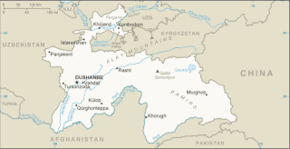
Tajikistan is nestled between Kyrgyzstan and Uzbekistan to the north and west, China to the east, and Afghanistan to the south. Mountains cover 93 percent of Tajikistan's surface area. The two principal ranges, the Pamir Mountains and the Alay Mountains, give rise to many glacier-fed streams and rivers, which have been used to irrigate farmlands since ancient times. Central Asia's other major mountain range, the Tian Shan, skirts northern Tajikistan. Mountainous terrain separates Tajikistan's two population centers, which are in the lowlands of the southern and northern sections of the country. Especially in areas of intensive agricultural and industrial activity, the Soviet Union's natural resource utilization policies left independent Tajikistan with a legacy of environmental problems.

The Ural Mountains, or simply the Urals, are a mountain range in Eurasia that runs north–south mostly through Russia, from the coast of the Arctic Ocean to the river Ural and northwestern Kazakhstan. The mountain range forms part of the conventional boundary between the continents of Europe and Asia. Vaygach Island and the islands of Novaya Zemlya form a further continuation of the chain to the north into the Arctic Ocean. The average altitudes of the Urals are around 1,000–1,300 metres (3,300–4,300 ft), the highest point being Mount Narodnaya, which reaches a height of 1,894 metres (6,214 ft).

Lenin Peak or Ibn Sina (Avicenna) Peak, rises to 7,134 metres (23,406 ft) in Gorno-Badakhshan (GBAO) on the Kyrgyzstan–Tajikistan border, and is the second-highest point of both countries. It is considered one of the less technical 7,000 m peaks in the world to climb and it has by far the most ascents of any 7,000 m or higher peak on Earth, with every year seeing hundreds of mountaineers make their way to the summit. Lenin Peak is the highest mountain in the Trans-Alay Range of Central Asia, and in the Pamir Mountains in Tajikistan it is exceeded only by Ismoil Somoni Peak. It was thought to be the highest point in the Pamirs in Tajikistan until 1933, when Ismoil Somoni Peak was climbed and found to be more than 300 metres higher. Two mountains in the Pamirs in China, Kongur Tagh and Muztagh Ata, are higher than the Tajik summits.

The urial, also known as arkars, shapo, or shapu, is a wild sheep native to Central and South Asia. It is listed as Vulnerable on the IUCN Red List.
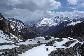
The Pamir Mountains are a range of mountains between Central Asia and South Asia. They are located at a junction with other notable mountains, namely the Tian Shan, Karakoram, Kunlun, Hindu Kush and the Himalaya mountain ranges. They are among the world's highest mountains.

The Alay or Alai Range is a mountain range that extends from the Tien Shan mountain range in Kyrgyzstan west into Tajikistan. It is part of the Pamir-Alay mountain system. The range runs approximately east to west. Its highest summit is Pik Tandykul, reaching 5544 m. It forms the southern border of the Fergana Valley, and in the south it falls steeply to the Alay Valley. The southern slopes of the range drain into the Kyzylsuu or Vakhsh River, a tributary of the Amu Darya. The streams that drain the northern slopes of the range are tributaries of the Syr Darya, and empty into the Fergana Valley to the north of the range. Pik Skobeleva, 5,051 metres (16,572 ft), is also a well-known summit. European route E007: Tashkent – Kokand – Andijan – Osh – Irkeshtam crosses the range by the Taldyk Pass. The range is also traversed by Pamir highway.

The Coast Ranges of California span 400 miles (644 km) from Del Norte or Humboldt County, California, south to Santa Barbara County. The other three coastal California mountain ranges are the Transverse Ranges, Peninsular Ranges and the Klamath Mountains.

Akto County is a county in Kizilsu Kyrgyz Autonomous Prefecture, Xinjiang Uygur Autonomous Region, China. The county borders Tajikistan and Kyrgyzstan and has two towns, 11 townships, four state-owned farms and a plant nursery under its jurisdiction with the county seat being Akto Town. The county contains an area of 24,555 km2 (9,481 sq mi) and has a population of 221,526 as of 2015, of 231,756 as of 2017.

The silver mountain vole is a species of rodent in the family Cricetidae. They are distinguished by their silver-grey pelage, long vibrissae, rootless hypsodont molars and angular skull shape. Like many mammals of the Eurasian Steppe eco-region, they are well adapted to life in high altitudes, and can be found in mountain areas of Central Asia from Saur Mountains in the north-east to Kugitang Range in the west, and to Tibet and the Himalayas in the south.

The Buchara shrew or Pamir shrew is a species of mammal in the family Soricidae. It is found in the Pamir Mountains in Tajikistan, Kyrgyzstan, and Uzbekistan. It lives in mountain birch and poplar forests on slopes and piedmonts.

One of the northern extensions of the Pamir-Alay system, the Turkestan Range stretches for a total length of 340 km from the Alay Mountains on the border of Kyrgyzstan with Tajikistan to the Samarkand oasis in Uzbekistan. It runs in the east–west direction, north of the Zeravshan Range, forming the southern boundary of the Ferghana Valley in Tajikistan and Golodnaya Steppe in Uzbekistan. The highest elevations are in the east, near the border with Kyrgyzstan. The maximum elevation is the Pik Skalisty at 5,621 metres (18,442 ft). Glaciation occurs especially in the east. The southern slopes are bare cliffs and mountain steppe; the northern slopes are covered with forests. A highway through the Shakhristan Pass at 3,378 meters (11,083 ft) connects the capital Dushanbe with Khujand in Northern Tajikistan.

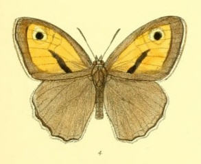
Hyponephele davendra, the white-ringed meadowbrown, is a butterfly species belonging to the family Nymphalidae. It can be found from Iran to Afghanistan, India, and Pakistan, the Himalayas, Tibet, and central Asia.
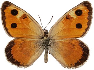
Hyponephele tenuistigma is a butterfly species belonging to the family Nymphalidae. It is found in Afghanistan, Pakistan, Kashmir and the western part of the Pamir Mountains.
Karanasa leechi is a butterfly of the family Nymphalidae. It is found in Asia, including the Darvaz Range in the Pamirs and the Hindu Kush.

Hemaris ducalis, the Pamir bee hawkmoth, is a moth of the family Sphingidae. It is known from the mountains of south-western Xinjiang in China, the western Tian Shan, southern and eastern Kazakhstan up to the Altai Mountains, western Mongolia, southern Uzbekistan, Kyrgyzstan, Tajikistan, northern Afghanistan and Pakistan.
The 1911 Sarez earthquake occurred at 18:41 UTC on 18 February in the central Pamir Mountains in the Rushon District of eastern Tajikistan. It had an estimated magnitude of 7.4 on the surface wave magnitude scale and a maximum felt intensity of about IX (Violent) on the Mercalli intensity scale. It triggered a massive landslide, blocking the Murghab River and forming the Usoi Dam, the tallest dam in the world, creating Sarez Lake. The earthquake and related landslides destroyed many buildings and killed about 100 people.

Pieris krueperi, the Krueper's small white, is a butterfly in the family Pieridae. It is found on the Balkan Peninsula and in Iran, Baluchistan, the Kopet-Dagh and from Asia Minor to Central Asia, as well as in Oman. The habitat consists arid areas with scanty vegetation up to 2,500 metres (8,200 ft) in the mountains.

The Ishkashim Important Bird Area, also spelt Ishkoshim, is a 1136 km2 tract of land in south-western Gorno-Badakhshan Autonomous Province in eastern Tajikistan.
Gelón is an urban-type settlement in the Shakhrisabz district of the Qashqadaryo Region of the Republic of Uzbekistan.

