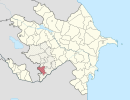
Coordinates: 39°14′37″N46°42′56″E / 39.24361°N 46.71556°E
A geographic coordinate system is a coordinate system that enables every location on Earth to be specified by a set of numbers, letters or symbols. The coordinates are often chosen such that one of the numbers represents a vertical position and two or three of the numbers represent a horizontal position; alternatively, a geographic position may be expressed in a combined three-dimensional Cartesian vector. A common choice of coordinates is latitude, longitude and elevation. To specify a location on a plane requires a map projection.
Hüseynuşağı | |
---|---|
Coordinates: 39°14′37″N46°42′56″E / 39.24361°N 46.71556°E | |
Country | |
Rayon | Qubadli |
Time zone | AZT (UTC+4) |
• Summer (DST) | AZT (UTC+5) |
Hüseynuşağı (also, Guseynushagy and Guseyn-Ushagi) is a village in the Qubadli Rayon of Azerbaijan.
Azerbaijan, officially the Republic of Azerbaijan, is a country in the South Caucasus region of Eurasia at the crossroads of Eastern Europe and Western Asia. It is bounded by the Caspian Sea to the east, Russia to the north, Georgia to the northwest, Armenia to the west and Iran to the south. The exclave of Nakhchivan is bounded by Armenia to the north and east, Iran to the south and west, and has an 11 km long border with Turkey in the northwest.
Hüseyinuşağı is the Kurdish village in Qubadli
Qaralar is a village in the Qubadli Rayon of Azerbaijan.
Kavdadıq is a village in the Qubadli Rayon of Azerbaijan.
Muğanlı is a village in the Qubadli Rayon of Azerbaijan.
Ballıqaya is a village in the Qubadli Rayon of Azerbaijan. Ballıqaya is the Azeri village in Qubadli
Dondarlı is a village in the Qubadli Rayon of Azerbaijan. Dondarlı is the Azeri village in Qubadli
Həmzəli is a village in the Qubadli Rayon of Azerbaijan.
Mahmudlu is a village in the Qubadli Rayon of Azerbaijan.
Qayalı is a village in the Qubadli Rayon of Azerbaijan.
Göyərcık is a village in the Qubadli Rayon of Azerbaijan. Göyərcik is the Azeri village in Qubadli
Qaracallı is a village in the Qubadli Rayon of Azerbaijan.
Bala Həsənli is a village in the Qubadli Rayon of Azerbaijan. Bala Həsənli is the Azeri village in Qubadli
Muradxanlı is a village in the Qubadli Rayon of Azerbaijan.
Qaraqoyunlu is a village in the Qubadli Rayon of Azerbaijan.
Gilidzhan is a village in the Qubadli Rayon of Azerbaijan. Gilidzhan is the Azeri and Kurdish village in Qubadli
Myuskanly is a village in the Qubadli Rayon of Azerbaijan.
Padar is a village in the Qubadli Rayon of Azerbaijan.
Mamedli is a village in the Qubadli Rayon of Azerbaijan.
Mazra is a village in the Qubadli Rayon of Azerbaijan.
Davudlu is a village in the Qubadli Rayon of Azerbaijan. Davudlu is the Azeri village in Qubadli
Həkəri is a village situated in Qubadli Rayon of Azerbaijan. It takes its name from a river with the same name with sources in the north of Qubadli Rayon. Before Armenian forces got control of the village it was part of the larger Muradkhanli village council (municipality) with three other villages of Qubadli Rayon. Moreover, most of what Qubadli is today was called Hakara according to the 18th century Ottoman Tax Registry.
The GEOnet Names Server (GNS) provides access to the National Geospatial-Intelligence Agency's (NGA) and the U.S. Board on Geographic Names's (BGN) database of geographic feature names and locations for locations outside the United States. The database is the official repository of foreign place-name decisions approved by the US BGN. Approximately 20,000 of the database's features are updated monthly. The database never removes an entry, "except in cases of obvious duplication".
This Qubadli Rayon location article is a stub. You can help Wikipedia by expanding it. |