
Cartography is the study and practice of making and using maps. Combining science, aesthetics and technique, cartography builds on the premise that reality can be modeled in ways that communicate spatial information effectively.

Fra Mauro, O.S.B. Cam., (c.1400–1464) was a Venetian cartographer who lived in the Republic of Venice. He created the most detailed and accurate map of the world up until that time, the Fra Mauro map.
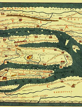
Tabula Peutingeriana, also referred to as Peutinger's Tabula or Peutinger Table, is an illustrated itinerarium showing the layout of the cursus publicus, the road network of the Roman Empire.
Raleigh Ashlin Skelton is best known for his work on the history of cartography and particularly his attempts to prove the authenticity of the Vinland map.
Bernard Wapowski (1475-1535) was one of the earliest Polish cartographers and is credited for making the first detailed map of Poland in 1526. Wapowski is considered to be the "Father of Polish Cartography". Wapowski served as the secretary of King Sigismund the Old and made several advancements in Polish cartography by creating several maps of Eastern Europe including Poland, Sarmatia, Scandinavia, Warmia (Ermland), and Pomerania with some assistance from Nicolaus Copernicus.

Dmitry Gerasimov, was a Russian translator, diplomat and philologist; he also provided some of the earliest information on Muscovy to Renaissance scholars such as Paolo Giovio and Sigismund von Herberstein.

"Majorcan cartographic school" is the term coined by historians to refer to the collection of predominantly Jewish cartographers, cosmographers and navigational instrument-makers and some Christian associates that flourished in Majorca in the 13th, 14th and 15th centuries until the expulsion of the Jews. The label is usually inclusive of those who worked in Catalonia. The Majorcan school is frequently contrasted with the contemporary Italian cartography school.
Semyon Ulyanovich Remezov was a Russian historian, architect and geographer of Siberia. He is responsible for compiling three collections of maps, charts and drawings of Siberia, which effectively became atlases of the area. Remezov's atlases were important to Peter the Great's imperial expansion into the eastern territory of Russia as they provided the Tsar with information on the Siberian landscape and the location of its indigenous communities. Such knowledge became necessary for future administrative and military projects in the area.
Catalan charts or Catalan portolans are portolan charts in the Catalan language. Portolan charts are a type of medieval and early modern map that focuses on maritime geography and includes a network of rhumb lines. Most medieval portolan charts were made in Italian-speaking cities, with a substantial minority made in Catalan-speaking Majorca. In the 19th century, historians of cartography emphasized the differences of style and content between Italian and Catalan charts, but other authors have nuanced this distinction since then.

Ammassalik wooden maps are carved, tactile maps of the Greenlandic coastlines. In the 1880s, Gustav Holm led an expedition to the Ammassalik coast of eastern Greenland, where he met several Tunumiit, or Eastern Greenland Inuit communities, who had had no prior direct contact with Europeans. He returned to Denmark with a set of three-dimensional wooden maps of the coast around 66°N 36°W, carved by a native of Umivik named Kunit.
Leo Bagrow, born Lev Solomonovich Bagrow, was a historian of cartography and the founder of the journal Imago Mundi.

Justus Danckerts I was a Dutch engraver and print publisher who along with other members of the Danckerts family created one of the leading Dutch geographical map and atlas publishing houses.

The Mercator world map of 1569 is titled Nova et Aucta Orbis Terrae Descriptio ad Usum Navigantium Emendate Accommodata. The title shows that Gerardus Mercator aimed to present contemporary knowledge of the geography of the world and at the same time 'correct' the chart to be more useful to sailors. This 'correction', whereby constant bearing sailing courses on the sphere are mapped to straight lines on the plane map, characterizes the Mercator projection. While the map's geography has been superseded by modern knowledge, its projection proved to be one of the most significant advances in the history of cartography, inspiring map historian Nordenskiöld to write "The master of Rupelmonde stands unsurpassed in the history of cartography since the time of Ptolemy." The projection heralded a new era in the evolution of navigation maps and charts and it is still their basis.
Rouben Galichian is an independent London-based scholar and researcher specializing in historical maps of Armenia and the South Caucasus region.

Pietro Coppo was an Italian geographer and cartographer who wrote a description of the entire world as known in the 16th century, accompanied by a set of systematically arranged maps, one of the first rutters and also a precise description of the Istrian Peninsula, accompanied by its first regional map.
Eila Muriel Joice Campbell was an English geographer and cartographer. She was best known for her work on Domesday Geography of England and her work on the international journal, Imago Mundi.
Ulla Ehrensvärd was a Swedish librarian, curator, and art historian, specializing in medals, architectural drawings, and maps.
The cartography of the region of Palestine, also known as cartography of the Holy Land and cartography of the Land of Israel, is the creation, editing, processing and printing of maps of the region of Palestine from ancient times until the rise of modern surveying techniques. For several centuries during the Middle Ages it was the most prominent subject in all of cartography, and it has been described as an "obsessive subject of map art".
Kazimierz Kozica was a Polish historian of cartography, map expert, teacher, curator. President of the Friends of the Royal Castle in Warsaw Association

Salvatore de Pilestrina, also known as Salvat de Pilestrina, was a mapmaker in Mallorca in the early 16th century.