Babylonian Map of the World

Last updated
Babylonian Map of the World
The Babylonian map of the world, from Sippar, Mesopotamia..JPG
Obverse
MaterialClay
SizeHeight: 12.2 cm (4.8 in)
Width: 8.2 cm (3.2 in)
Writing cuneiform
Createdafter 9th century BC
Period/culture Neo-Babylonian
/ early Achaemenid period
Place Sippar
Present location British Museum, (BM 92687)

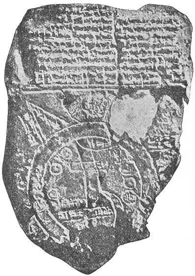
The Babylonian Map of the World (also Imago Mundi or Mappa mundi) is a Babylonian clay tablet with a schematic world map and two inscriptions written in the Akkadian language. Dated to no earlier than the 9th century BC (with a late 8th or 7th century BC date being more likely), it includes a brief and partially lost textual description. The tablet describes the oldest known depiction of the known world. Ever since its discovery there has been controversy on its general interpretation and specific features. [1] Another pictorial fragment, VAT 12772, presents a similar topography from roughly two millennia earlier. [2]

Contents

The map is centered on the Euphrates, flowing from the north (top) to the south (bottom), with its mouth labelled "swamp" and "outflow". The city of Babylon is shown on the Euphrates, in the northern half of the map. Susa, the capital of Elam, is shown to the south, Urartu to the northeast, and Habban, the capital of the Kassites, is shown (incorrectly) to the northwest. Mesopotamia is surrounded by a circular "bitter river" or Ocean, and seven or eight foreign regions are depicted as triangular sections beyond the Ocean, perhaps imagined as mountains. [3]

The tablet was excavated by Hormuzd Rassam at Sippar, Baghdad vilayet, [4] some 60 km north of Babylon on the east bank of the Euphrates River. It was acquired by the British Museum in 1882 (BM 92687); [4] the text was first translated in 1889. [5] The tablet is usually thought to have originated in Borsippa. [6] In 1995, a new section of the tablet was discovered, at the point of the upper-most triangle. [7]

The map is used as the logo of the academic journal Imago Mundi. [8]

Description of the tablet

The tablet consists of three parts: the world map, a text above it, and a text on the reverse side. It is not clear whether all three parts should be read as a single document. Systematic differences between the texts suggest that the tablet may have been compiled from three separate documents. [9]

The map

Babylonian Map of the World with false color 4000BCE map of the world showing Armeny Ashur Bavel Akkad-British Museum-Object Number-92687-PubDomain-details5.svg
Babylonian Map of the World with false color

The map is circular with two boundary circles. Cuneiform script labels all locations inside the circular map, as well as a few regions outside. The two circles represent a body of water labelled idmaratum "bitter river", the salt sea. Babylon is marked north of center; parallel lines at the bottom seem to represent the southern marshes, and a curved line coming from the north-northeast appear to represent the Zagros Mountains. [10] [11] [12] [13] [14]

Drawing by B. Meissner in Babylonien und Assyrien, 1925. Meissner Babylonien und Assyrien clay map 1925.jpg
Drawing by B. Meissner in Babylonien und Assyrien, 1925.

There are seven small interior circles within the perimeter of the circle, appearing to represent seven cities. Seven or eight triangular sections outside the water circle represent named "regions" (nagu). The descriptions for five of them have survived. [4]

Objects on the Babylonian map of the world [10]
BabylonianWorldMap2.jpg
1. "Mountain" (Akkadian : šá-du-ú)

2. "City" (Akkadian : uru)
3. Urartu (Akkadian : ú-ra-áš-tu)
4. Assyria (Akkadian : kuraš+šurki)
5. Der (Akkadian : dēr) (a city)
6. ?
7. Swamp (Akkadian : ap-pa-ru )
8. Susa (capital of Elam) (Akkadian : šuša)
9. Canal/"outflow" (Akkadian : bit-qu)
10. Bit Yakin (Akkadian : bῑt-ia-᾿-ki-nu) (a region)
11. "City" (Akkadian : uru)

12. Habban (Akkadian : ha-ab-ban) (a Kassite land and city)

13. Babylon (Akkadian : tin.tirki), divided by Euphrates
14 17. Ocean (salt water, Akkadian : idmar-ra-tum)
19 22 (and 18?). outer "regions" (nagu):
18. "Great Wall, 6 leagues in between, where the Sun is not seen" (Akkadian : BÀD.GU.LA 6 bēru ina bi-rit a-šar Šamaš la innammaru). The "Great Wall" may be a mountain ridge, the "6 leagues in between" probably refer to the width of the Ocean. [15]
19. "nagu, 6 leagues in between"
20. "[nag]u [..." (rest of text missing)
21. "[na]gu [..." (rest of text missing)
22. "nagu, 8 leagues in between"
23. No description. (a city in Assyria?)
24, 25. No description. (cities in Habban?)

Accompanying texts

Front side

The text above the map [16] (11 lines) seems to describe part of the creation of the world by Marduk, the patron god of Babylon, who parted the primeval Ocean (the goddess Tiamat) and thus created Land and Sea. Of the Sea it says:

the ruine[d] gods which he (Marduk) set[tled] inside the Sea [...] are present; the viper, the great sea-serpent inside.

Next, on Land, a series of two mythical creatures ("the Anzu-bird, and scorpi[on-man]") and at least fifteen land animals are mentioned, "beasts which Marduk created on top of the res[tl]ess Sea" (i.e. on the land, visualized as a kind of giant raft floating in the Sea), among them mountain goat, gazelle, lion, wolf, monkey and female-monkey, ostrich, cat, and chameleon. With the exception of the cat, all these animals were typical of faraway lands.

The last two lines of the text refer to three legendary heroes: [U]tnapištim (the hero of the Flood), Sargon (ruler of Akkad), and Nur-[D]agan the King of Buršaḫa[nda] (opponent of Sargon). [17]

Back side

The back side [18] (29 lines) seems to be a description of (at least) eight nagu. After an introduction, possibly explaining how to identify the first nagu, the next seven nagu are each introduced by the clause "To the n-th region [nagu], where you travel 7 leagues" (the distance of 7 leagues seems to indicate the width of the Ocean, rather than the distance between subsequent nagu). [19]

A short description is given for each of the eight nagu, but those of the first, second, and sixth are too damaged to read. The fifth nagu has the longest description, but this too is damaged and uncomprehensible. The seventh nagu is more clear:

... where cattle equipped with horns [are ...] they run fast and reach [...]

The third nagu may be a barren desert, impassable even for birds:

A winged [bi]rd cannot safely comp[lete its journey]

In the fourth nagu objects are found of remarkable dimensions:

[...] are thick as a parsiktum-measure, 20 fingers [...]

The eighth nagu may refer to a supposed heavenly gate in the east where the Sun enters as it rises in the morning.

[... the p]lace where [...] dawns at its entrance.

Concluding, the description then states that the map is a bird's eye description:

of the Four Quadrants of the entire [world?] [...] which no one can compre[hend] [i.e., the nagu extend infinitely far]

The last two lines apparently recorded the name of the scribe who wrote the tablet:

[...] copied from its old exemplar and colla[ted ...] the son of Iṣṣuru [the descend]ant of Ea-bēl-il[ī].

Later influence

Carlo Zaccagnini has argued that the design of the Babylonian map of the world may have lived on in the T and O maps of the European Middle Ages. [20]

See also

Related Research Articles

<span class="mw-page-title-main">Babylonia</span> Ancient Akkadian region in Mesopotamia

Babylonia was an ancient Akkadian-speaking state and cultural area based in the city of Babylon in central-southern Mesopotamia. It emerged as an Akkadian populated but Amorite-ruled state c. 1894 BC. During the reign of Hammurabi and afterwards, Babylonia was retrospectively called "the country of Akkad", a deliberate archaism in reference to the previous glory of the Akkadian Empire. It was often involved in rivalry with the older ethno-linguistically related state of Assyria in the north of Mesopotamia and Elam to the east in Ancient Iran. Babylonia briefly became the major power in the region after Hammurabi created a short-lived empire, succeeding the earlier Akkadian Empire, Third Dynasty of Ur, and Old Assyrian Empire. The Babylonian Empire rapidly fell apart after the death of Hammurabi and reverted to a small kingdom centered around the city of Babylon.

<span class="mw-page-title-main">Hanging Gardens of Babylon</span> Hellenistic legend about gardens in Babylon

The Hanging Gardens of Babylon were one of the Seven Wonders of the Ancient World listed by Hellenic culture. They were described as a remarkable feat of engineering with an ascending series of tiered gardens containing a wide variety of trees, shrubs, and vines, resembling a large green mountain constructed of mud bricks. It was said to have been built in the ancient city of Babylon, near present-day Hillah, Babil province, in Iraq. The Hanging Gardens' name is derived from the Greek word κρεμαστός, which has a broader meaning than the modern English word "hanging" and refers to trees being planted on a raised structure such as a terrace.

Sippar was an ancient Near Eastern Sumerian and later Babylonian city on the east bank of the Euphrates river. Its tell is located at the site of modern Tell Abu Habbah near Yusufiyah in Iraq's Baghdad Governorate, some 69 km (43 mi) north of Babylon and 30 km (19 mi) southwest of Baghdad. The city's ancient name, Sippar, could also refer to its sister city, Sippar-Amnanum ; a more specific designation for the city here referred to as Sippar was Sippar-Yaḫrurum (Sippar-Jaḫrurum). The name comes from the Amorite Yaḫrurum tribe that lived in the area along with the Amorite Amnanum tribe. In Sippar was the site where the Babylonian Map of the World was found.

<span class="mw-page-title-main">Kassites</span> People of the ancient Near East

The Kassites were people of the ancient Near East, who controlled Babylonia after the fall of the Old Babylonian Empire c. 1531 BC and until c. 1155 BC.

<span class="mw-page-title-main">Old Babylonian Empire</span> 2nd millennium BCE empire in Babylonia

The Old Babylonian Empire, or First Babylonian Empire, is dated to c. 1894–1595 BC, and comes after the end of Sumerian power with the destruction of the Third Dynasty of Ur, and the subsequent Isin-Larsa period. The chronology of the first dynasty of Babylonia is debated; there is a Babylonian King List A and also a Babylonian King List B, with generally longer regnal lengths. In this chronology, the regnal years of List A are used due to their wide usage.

<i>Enūma Eliš</i> Babylonian creation myth

Enūma Eliš, meaning "When on High", is a Babylonian creation myth from the late 2nd millennium BCE and the only complete surviving account of ancient near eastern cosmology. It was recovered by English archaeologist Austen Henry Layard in 1849 in the ruined Library of Ashurbanipal at Nineveh. A form of the myth was first published by English Assyriologist George Smith in 1876; active research and further excavations led to near completion of the texts and improved translation.

<span class="mw-page-title-main">Nabu</span> Mesopotamian god of literacy and scribes

Nabu is the Babylonian patron god of literacy, the rational arts, scribes, and wisdom. He is associated with the classical planet Mercury in Babylonian astronomy.

<span class="mw-page-title-main">Royal Game of Ur</span> Ancient Mesopotamian board game

The Royal Game of Ur is a two-player strategy race board game of the tables family that was first played in ancient Mesopotamia during the early third millennium BC. The game was popular across the Middle East among people of all social strata, and boards for playing it have been found at locations as far away from Mesopotamia as Crete and Sri Lanka. One board, held by the British Museum, is dated to c. 2600 – c. 2400 BC, making it one of the oldest game boards in the world.

<span class="mw-page-title-main">Cyrus Cylinder</span> Ancient clay cylinder with Akkadian cuneiform script

The Cyrus Cylinder is an ancient clay cylinder, now broken into several pieces, on which is written an Achaemenid royal inscription in Akkadian cuneiform script in the name of the Persian king Cyrus the Great. It dates from the 6th century BC and was discovered in the ruins of the ancient Mesopotamian city of Babylon in 1879. It is currently in the possession of the British Museum. It was created and used as a foundation deposit following the Persian conquest of Babylon in 539 BC, when the Neo-Babylonian Empire was invaded by Cyrus and incorporated into his Persian Empire.

<span class="mw-page-title-main">Sarpanit</span>

Zarpanitu was a Mesopotamian goddess regarded as the spouse of Marduk. Not much is known about her character, though late sources indicate that she was associated with pregnancy and that she could be assigned similar roles as her husband, including that of queen of the gods. She was originally worshiped in Zarpan, a village near Babylon, though the latter city itself also served as her cult center.

<span class="mw-page-title-main">Nabonidus Chronicle</span> Ancient Babylonian text

The Nabonidus Chronicle is an ancient Babylonian text, part of a larger series of Babylonian Chronicles inscribed in cuneiform script on clay tablets. It deals primarily with the reign of Nabonidus, the last king of the Neo-Babylonian Empire, covers the conquest of Babylon by the Persian king Cyrus the Great, and ends with the start of the reign of Cyrus's son Cambyses II, spanning a period from 556 BC to some time after 539 BC. It provides a rare contemporary account of Cyrus's rise to power and is the main source of information on this period; Amélie Kuhrt describes it as "the most reliable and sober [ancient] account of the fall of Babylon."

<span class="mw-page-title-main">Nazi-Maruttash</span> King of Babylon

Nazi-Maruttaš, typically inscribed Na-zi-Ma-ru-ut-ta-aš or mNa-zi-Múru-taš, Maruttašprotects him, was a Kassite king of Babylon c. 1307–1282 BC and self-proclaimed šar kiššati, or "King of the World", according to the votive inscription pictured. He was the 23rd of the dynasty, the son and successor of Kurigalzu II, and reigned for twenty six years.

<span class="mw-page-title-main">Marduk-nadin-ahhe</span> King of Babylon

Marduk-nādin-aḫḫē, inscribed mdAMAR.UTU-na-din-MU, reigned c. 1095–1078 BC, was the sixth king of the Second Dynasty of Isin and the 4th Dynasty of Babylon. He is best known for his restoration of the Eganunmaḫ in Ur and the famines and droughts that accompanied his reign.

<i>Ludlul bēl nēmeqi</i> Mesopotamian poem written in Akkadian

Ludlul bēl nēmeqi, also sometimes known in English as The Poem of the Righteous Sufferer, is a Mesopotamian poem written in Akkadian that concerns itself with the problem of the unjust suffering of an afflicted man, named Šubši-mašrâ-Šakkan (Shubshi-meshre-Shakkan). The author is tormented, but he does not know why. He has been faithful in all of his duties to the gods. He speculates that perhaps what is good to man is evil to the gods and vice versa. He is ultimately delivered from his sufferings. It is thought to have been composed during the reign of Kassite king of Babylon Nazi-Maruttaš, who is mentioned on line 105 of tablet IV.

<span class="mw-page-title-main">Nabu-apla-iddina</span> King of Babylon

Nabû-apla-iddina, inscribed mdNábû-ápla-iddinana or mdNábû-apla-íddina; reigned about 886–853 BC, was the sixth king of the dynasty of E of Babylon and he reigned for at least thirty-two years. During much of Nabû-apla-iddina's reign Babylon faced a significant rival in Assyria under the rule of Ashurnasirpal II. Nabû-apla-iddina was able to avoid both outright war and significant loss of territory. There was some low level conflict, including a case where he sent a party of troops led by his brother to aid rebels in Suhu. Later in his reign Nabu-apla-iddina agreed to a treaty with Ashurnasirpal II’s successor Shalmaneser III. Internally Nabu-apla-iddina worked on the reconstruction of temples and something of a literary revival took place during his reign with many older works being recopied.

<span class="mw-page-title-main">Babylon</span> Ancient Mesopotamian city in Iraq

Babylon was an ancient city located on the lower Euphrates river in southern Mesopotamia, within modern-day Hillah, Iraq, about 85 kilometers south of modern day Baghdad. Babylon functioned as the main cultural and political centre of the Akkadian-speaking region of Babylonia. Its rulers established two important empires in antiquity, the 19th–16th century BC Old Babylonian Empire, and the 7th–6th century BC Neo-Babylonian Empire. Babylon was also used as a regional capital of other empires, such as the Achaemenid Empire. Babylon was one of the most important urban centres of the ancient Near East, until its decline during the Hellenistic period. Nearby ancient sites are Kish, Borsippa, Dilbat, and Kutha.

<span class="mw-page-title-main">Agum II</span> King of Babylon

Agum II was possibly a Kassite ruler who may have become the 8th or more likely the 9th king of the third Babylonian dynasty sometime after Babylonia was defeated and sacked by the Hittite king Mursilis I in 1595 BC, establishing the Kassite Dynasty which was to last in Babylon until 1155 BC. A later tradition, the Marduk Prophecy, gives 24 years after a statue was taken, before it returned of its own accord to Babylon, suggesting a Kassite occupation beginning around 1507 BC.

Adad-apla-iddina, typically inscribed in cuneiform mdIM-DUMU.UŠ-SUM-na, mdIM-A-SUM-na or dIM-ap-lam-i-din-[nam] meaning the storm god “Adad has given me an heir”, was the 8th king of the 2nd Dynasty of Isin and the 4th Dynasty of Babylon and ruled c. 1064–1043. He was a contemporary of the Assyrian King Aššur-bêl-kala and his reign was a golden age for scholarship.

<span class="mw-page-title-main">Dynastic Chronicle</span>

The Dynastic Chronicle, "Chronicle 18" in Grayson's Assyrian and Babylonian Chronicles or the "Babylonian Royal Chronicle" in Glassner’s Mesopotamian Chronicles, is a fragmentary ancient Mesopotamian text extant in at least four known copies. It is actually a bilingual text written in 6 columns, representing a continuation of the Sumerian king list tradition through to the 8th century BC and is an important source for the reconstruction of the historical narrative for certain periods poorly preserved elsewhere.

<span class="mw-page-title-main">Babylonian revolts (484 BC)</span> Revolts of two rebel kings of Babylon

The Babylonian revolts of 484 BC were revolts of two rebel kings of Babylon, Bel-shimanni and Shamash-eriba, against Xerxes I, king of the Persian Achaemenid Empire.

References

  1. Delnero, Paul. "A Land with No Borders: A New Interpretation of the Babylonian “Map of the World”." Journal of Ancient Near Eastern History 4.1-2 (2017): 19-37
  2. Wiggermann 1996, p. 208–209.
  3. Lewy H., Lewy J., "The Origin of the Week and the Oldest West Asiatic Calendar", The Hebrew Union College Annual 17 (1943), 1—146.
  4. 1 2 3 British Museum Inv. No.92687.
  5. F. E. Peiser ZA 4 (1889) 361-370. First publication of a photographic reproduction: C. Ball, Light from The East (1899), p. 23.
  6. Horowitz, Wayne. 2011. Mesopotamian Cosmic Geography. 2nd ed. Mesopotamian Civilizations 8. Winona Lake, Indiana: Eisenbrauns
  7. Finkel, Irving. 1995. "A Join to the Map of the World: A Notable Discovery". British Museum Magazine: The Journal of the British Museum Friends 23: 26–27
  8. Smith, Catherine Delano, "Imago Mundi’s Logo the Babylonian Map of the World", Imago Mundi, vol. 48, pp. 209–11, 1996
  9. Horowith 1998, pp. 26, 30.
  10. 1 2 Horowitz, Wayne, "The Babylonian Map of the World", iraq, vol. 50, pp. 147-165, 1988
  11. Horowitz, Wayne, "Cosmic Geography: Mesopotamian Cosmic Geography", Winona Lake, IN: Eisenbraun, 1998
  12. F.E. Peier ZA 4 (1889), R.C. Thompson, "Cuneiform texts from Babylonian tablets", pp. 22-48, 1906
  13. E. Weidner, BoSt 6, pp. 85-93, 1922
  14. E. Unger, "Babylon", pp. 254-258, 1931
  15. Horowitz 1998, pp. 30, 32.
  16. Horowith 1998, pp. 22-23, 33-37.
  17. Horowith 1998, pp. 20–42.
  18. Horowith 1998, pp. 23–25, 37–40.
  19. Horowith 1998, p. 30.
  20. Carlo Zaccagnini, ‘Maps of the World’, in Giovanni B. Lanfranchi et al., Leggo! Studies Presented to Frederick Mario Fales on the occasion of his 65th birthday, Wiesbaden, Harrassowitz Verlag, 2012, pp. 865-874.

Sources

Further reading