Related Research Articles

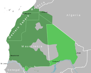
Western Sahara is a disputed territory in North-western Africa. It has a surface area of 272,000 square kilometres (105,000 sq mi). Approximately 30% of the territory is controlled by the Sahrawi Arab Democratic Republic (SADR); the remaining 70% is occupied and administered by neighboring Morocco. It is the most sparsely populated territory in Africa and the second most sparsely populated territory in the world, mainly consisting of desert flatlands. The population is estimated at 618,600. Nearly 40% of that population lives in Morocco-controlled Laayoune, the largest city of Western Sahara.
The history of Western Sahara can be traced back to the times of Carthaginian explorer Hanno the Navigator in the 5th century BC. Though few historical records are left from that period, Western Sahara's modern history has its roots linked to some nomadic groups such as the Sanhaja group, and the introduction of Islam and the Arabic language at the end of the 8th century AD.
La Güera is a ghost town on the Atlantic coast at the southern tip of Western Sahara, on the western side of the Ras Nouadhibou peninsula which is split in two by the Mauritania–Western Sahara border, 15 kilometres (9.3 mi) west of Nouadhibou. It is also the name of a daira at the Sahrawi refugee camps in south-western Algeria.

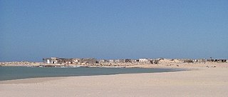
Dakhla is a city in the disputed territory of Western Sahara, currently occupied by Morocco. It is the capital of the claimed Moroccan administrative region Dakhla-Oued Ed-Dahab. It has a population of 106,277 and is on a narrow peninsula of the Atlantic Coast, the Río de Oro Peninsula, about 550 km (340 mi) south of Laayoune.

The Atlantic humpback dolphin is a species of humpback dolphin that is found in coastal areas of West Africa.
Beni Ḥassan is a Bedouin Arab tribe which inhabits Western Sahara, Mauritania, Morocco and Algeria. It is one of the four sub-tribes of the Banu Maqil who emigrated in the 11th century from South Arabia to the Maghreb with the Banu Hilal and Banu Sulaym Arab tribes. In the 13th century, they took the Sanhaja territories in the southwest of the Sahara. In Morocco, they first settled, alongside their Maqil relatives, in the area between Tadla and the Moulouya River. The Sous Almohad governor called upon them for help against a rebellion in the Sous, and they resettled in and around that region. They later moved to what is today Mauritania, and from the 16th century onwards, they managed to push back all black peoples southwards to the Senegal Valley river. The Beni Hassan and other warrior Arab tribes dominated the Sanhaja Berber tribes of the area after the Char Bouba war of the 17th century. As a result, Arabs became the dominant ethnic group in Western Sahara and Mauretania. The Bani Hassan dialect of Arabic became used in the region and is still spoken, in the form of Hassaniya Arabic. The hierarchy established by the Beni Hassan tribe gave Mauritania much of its sociological character. That ideology has led to oppression, discrimination and even enslavement of other groups in Mauritania.
Hassaniya Arabic is a variety of Maghrebi Arabic spoken by Mauritanian and Malian Arabs and the Sahrawi people. It was spoken by the Beni Ḥassān Bedouin tribes of Yemeni origin who extended their authority over most of Mauritania and Western Sahara between the 15th and 17th centuries. Hassaniya Arabic was the language spoken in the pre-modern region around Chinguetti.
The Sahrawis, or Sahrawi people, are an ethnic group native to the western part of the Sahara desert, which includes the Western Sahara, southern Morocco, much of Mauritania, and along the southwestern border of Algeria. They are of mixed Hassani Arab and Sanhaji Berber descent, as well as West African and other indigenous populations.

The Banc d'Arguin National Park of Bay of Arguin lies in Western Africa on the west coast of Mauritania between Nouakchott and Nouadhibou and is the former mouth of the Tamanrasset River. The World Heritage Site is a major site for migratory birds and breeding birds, including flamingos, pelicans and terns. Much of the breeding is on sand banks including the islands of Tidra, Niroumi, Nair, Kijji and Arguim. The surrounding waters are some of the richest fishing waters in western Africa and serve as nesting grounds for the entire western region.

The Sanhaja were once one of the largest Berber tribal confederations, along with the Zanata and Masmuda confederations. Many tribes in Algeria, Libya, Mali, Mauritania, Morocco, Niger, Senegal, Tunisia and Western Sahara bore and still carry this ethnonym, especially in its Berber form.
The Bafour or Bafur were a group of people inhabiting Mauritania and Western Sahara. Scholars such as H.T. Norris describe "Bafur (Bafour)" as a loose term encompassing the pre-Sanhaja inhabitants of the region, who were "part Berber, part Negro, and part Semite."

Ras Nouadhibou is a 60-kilometre (37 mi) peninsula or headland divided by the border between Mauritania and Western Sahara on the African coast of the Atlantic Ocean. It is internationally known as Cabo Blanco in Spanish or Cap Blanc in French.

Tidra is an offshore island 29 kilometres long and 8 km (5 mi) wide. It is the largest island off the shore of Banc d' Arguin, Mauritania and is home to a community of Imraguen fishing tribe. The island is part of the Banc d'Arguin National Park.
Nair is a small offshore island off the Banc d'Arguin National Park, Mauritania. It is an important breeding ground for spoonbills and slender-billed gulls. The island is part of the mud flats of the Banc d'Arguin and barely above sea level. As the oceans rise the island is disappearing and has already shrunk considerably from its historic size.
Mauritania's wildlife has two main influences as the country lies in two biogeographic realms. The north sits in the Palearctic which extends south from the Sahara to roughly 19° north latitude and the south is in the Afrotropic realm. Additionally, Mauritania is an important wintering area for numerous birds which migrate from the Palearctic.

Precolonial Mauritania, lying next to the Atlantic coast at the western edge of the Sahara Desert, received and assimilated into its complex society many waves of Saharan migrants and conquerors.

Mauritania, formally the Islamic Republic of Mauritania, is a sovereign country in Northwest Africa. It is bordered by the Atlantic Ocean to the west, Western Sahara to the north and northwest, Algeria to the northeast, Mali to the east and southeast, and Senegal to the southwest. By land area Mauritania is the 11th-largest country in Africa and 28th-largest in the world; 90% of its territory is in the Sahara. Most of its population of some 4.3 million lives in the temperate south of the country, with roughly a third concentrated in the capital and largest city, Nouakchott, on the Atlantic coast.
Nouamghar is a coastal village and rural commune in the Dakhlet Nouadhibou region of western Mauritania. The village is 150 kilometers north north-east of the capital Nouakchott and is located at the entrance to Cape Timiris.
Cintra Bay or the Gulf of Cintra is a large, half-moon shaped bay on the coast of Río de Oro province, Western Sahara. It is located about 120 km (75 mi) south of Dakhla. Its coastline is sparsely populated, and the environment is mostly wild and undeveloped. Originally called "St. Cyprian's Bay", it was renamed after Captain Gonçalo de Sintra, a 15th-century Portuguese explorer who was thought to have met his death in the bay during an unauthorized, unsuccessful slave raid.

Western Saharan cuisine comprises the cuisine of Western Sahara, a disputed territory in the Maghreb region of North Africa, bordered by Morocco to the north, Algeria to the extreme northeast, Mauritania to the east and south, and the Atlantic Ocean to the west. The Western Saharan cuisine has several influences, as the population of that area (Sahrawi), in their most part are of Arabic and Berber origin. The Saharawi cuisine is also influenced by Spanish cuisine owing to Spanish colonization.
References
- ↑ Virginia Thompson and Richard Adloff, The Western Saharans, 1980, ISBN 0-7099-0369-3, page 50
- 1 2 Fishermen who "walk on water" burn their nets, Panda.org, 5 May 2004
- 1 2 (in Spanish) El pueblo imraguen, protector de la cultura y naturaleza en Mauritana, Webislam.com, 17 June 2006
- 1 2 3 4 5 (in French) Jean-Pierre Turquoi, Mauritanie : au pays des Imraguen, Lemonde.fr, 11 April 2008
- ↑ (in Spanish) Jesús Cabaleiro Larrán, La Güera, ciudad fantasma del Sahara, Periodistas-es.com, 1 August 2016
- ↑ "Language Representative Counts" . Retrieved 2023-09-01.
- ↑ Hammarström (2015) Ethnologue 16/17/18th editions: a comprehensive review: online appendices