Google LLC is an American multinational technology company that focuses on search engine technology, online advertising, cloud computing, computer software, quantum computing, e-commerce, artificial intelligence, and consumer electronics. It has been referred to as the "most powerful company in the world" and one of the world's most valuable brands due to its market dominance, data collection, and technological advantages in the area of artificial intelligence. It is considered one of the Big Five American information technology companies, alongside Amazon, Apple, Meta, and Microsoft.

Google Maps is a web mapping platform and consumer application offered by Google. It offers satellite imagery, aerial photography, street maps, 360° interactive panoramic views of streets, real-time traffic conditions, and route planning for traveling by foot, car, bike, air and public transportation. As of 2020, Google Maps was being used by over 1 billion people every month around the world.

Google Earth is a computer program that renders a 3D representation of Earth based primarily on satellite imagery. The program maps the Earth by superimposing satellite images, aerial photography, and GIS data onto a 3D globe, allowing users to see cities and landscapes from various angles. Users can explore the globe by entering addresses and coordinates, or by using a keyboard or mouse. The program can also be downloaded on a smartphone or tablet, using a touch screen or stylus to navigate. Users may use the program to add their own data using Keyhole Markup Language and upload them through various sources, such as forums or blogs. Google Earth is able to show various kinds of images overlaid on the surface of the earth and is also a Web Map Service client. In 2019, Google has revealed that Google Earth now covers more than 97 percent of the world, and has captured 10 million miles of Street View imagery.

The Red Line is a metro rail line of the Delhi Metro, a rapid transit system in Delhi, India. It is an entirely elevated line and has 29 stations that runs from Rithala to Shaheed Sthal with a total distance of 34.55 km. The Tis Hazari – Shahdara section of this line was the first stretch of the Delhi Metro that was constructed and commissioned. The line connects the areas of Ghaziabad in Uttar Pradesh and the districts of Shahdara, Central Delhi and North West Delhi in Delhi.

The Kennedy Highway is a highway in northern Queensland, Australia. It runs as National Route 1 for approximately 243 km from Smithfield, on the northern outskirts of Cairns, to the Gulf Developmental Road in the vicinity of Forty Mile Scrub and Undara Volcanic national parks. South of this junction, the road continues as the Kennedy Developmental Road to Boulia about 936 kilometres away, via Hughenden. West of the junction, National Route 1 continues as the Gulf Developmental Road to Normanton.
Highway 265 is a provincial highway in the north-east region of Canadian province of Saskatchewan. It runs from Highway 120 to Highway 926. Highway 265 is about 29 km (18 mi) long.

Google Street View is a technology featured in Google Maps and Google Earth that provides interactive panoramas from positions along many streets in the world. It was launched in 2007 in several cities in the United States, and has since expanded to include cities and rural areas worldwide. Streets with Street View imagery available are shown as blue lines on Google Maps.
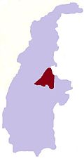
Srah Reang is a khum (commune) of Mongkol Borei District in Banteay Meanchey Province in western Cambodia.

Pichai Sundararajan, better known as Sundar Pichai, is an Indian-American business executive. He is the chief executive officer (CEO) of Alphabet Inc. and its subsidiary Google.
Waze, formerly FreeMap Israel, is a subsidiary of Google that provides satellite navigation software. It works on smartphones and other computers that have Global Positioning System (GPS) support. It provides turn-by-turn navigation information and user-submitted travel times and route details, while downloading location-dependent information over a mobile telephone network. Waze describes its app as a community-driven GPS navigation app that is free to download and use.
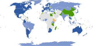
Google Street View was first introduced in the United States on May 25, 2007, and until November 26, 2008, featured camera icon markers, each representing at least one major city or area, and usually the other nearby cities, towns, suburbs, and parks. Many areas that had coverage were represented by icons.

Apple Maps is a web mapping service developed by Apple Inc. The default map system of iOS, iPadOS, macOS, and watchOS, it provides directions and estimated times of arrival for driving, walking, cycling, and public transportation navigation. A "Flyover" mode shows certain densely populated urban centers and other places of interest in a 3D landscape composed of models of buildings and structures.
Google Chrome is a freeware web browser developed by Google LLC. The development process is split into different "release channels", each working on a build in a separate stage of development. Chrome provides four channels: Stable, Beta, Dev, and Canary. Chrome is updated every two to three weeks on the stable builds for minor releases and every four weeks for major releases.
Google Play Services is a proprietary background service and API package produced by Google for Android devices. When it was introduced in 2012, it provided access to the Google+ APIs and OAuth 2.0. It expanded to cover a variety of Google services, allowing applications to communicate with the services through common means.

Pampas is a rural locality in the Toowoomba Region, Queensland, Australia. In the 2016 census, Pampas had a population of 62 people.

The Carlton Bridge is a railroad vertical-lift bridge which carries one rail line over the Kennebec River between Bath and Woolwich, Maine. It was completed in 1927. Until August 1, 2000, it also carried two lanes of U.S. Route 1 (US 1) on its upper deck, after which the highway was transferred to the adjoining Sagadahoc Bridge and the road connection severed at the west end. The east end is gated, and is accessible only by authorized vehicles. The majority of the road deck remains but may be removed in the future. It is the last downstream fixed crossing of the Kennebec.
/e/ is an Android-based mobile operating system and associated online services. The operating system is a fork of LineageOS and Android. The custom firmware is developed by the /e/ Foundation, which was founded by French entrepreneur Gaël Duval. /e/ is presented as privacy software that does not contain proprietary Google apps or services, and challenges the public to "find any parts of the system or default applications that are still leaking data to Google."

The R603 road is a regional road in County Cork, Ireland. It travels from the R586 at Bandon Bridge in Bandon south to the R600 at Garranereagh, via Kilbrittain. In Bandon, the route is split on joining and leaving the N71 road. The road is 13.0 kilometres (8.1 mi) long.