Bingham County is a county in the U.S. state of Idaho. As of the 2020 United States Census, the population was 47,992. The county seat and largest city is Blackfoot.

Benewah County is a county located in the northwest part of the U.S. state of Idaho. As of the 2020 United States Census the county had a population of 9,530. The county seat and largest city is St. Maries, which has some area inside the Coeur d'Alene Reservation.

The M61 is a motorway in North West England between Manchester and Preston, linking the M60 Manchester Orbital Motorway with the M6 Midlands-to-Scotland motorway.

Google LLC is an American multinational technology company focusing on search engine technology, online advertising, cloud computing, computer software, quantum computing, e-commerce, artificial intelligence, and consumer electronics. It has been referred to as "the most powerful company in the world" and one of the world's most valuable brands due to its market dominance, data collection, and technological advantages in the area of artificial intelligence. Its parent company Alphabet is considered one of the Big Five American information technology companies, alongside Amazon, Apple, Meta, and Microsoft.

Google Maps is a web mapping platform and consumer application offered by Google. It offers satellite imagery, aerial photography, street maps, 360° interactive panoramic views of streets, real-time traffic conditions, and route planning for traveling by foot, car, bike, air and public transportation. As of 2020, Google Maps was being used by over 1 billion people every month around the world.

Google Earth is a computer program that renders a 3D representation of Earth based primarily on satellite imagery. The program maps the Earth by superimposing satellite images, aerial photography, and GIS data onto a 3D globe, allowing users to see cities and landscapes from various angles. Users can explore the globe by entering addresses and coordinates, or by using a keyboard or mouse. The program can also be downloaded on a smartphone or tablet, using a touch screen or stylus to navigate. Users may use the program to add their own data using Keyhole Markup Language and upload them through various sources, such as forums or blogs. Google Earth is able to show various kinds of images overlaid on the surface of the earth and is also a Web Map Service client. In 2019, Google has revealed that Google Earth now covers more than 97 percent of the world, and has captured 10 million miles of Street View imagery.
Highway 909 is a provincial highway in the far north region of the Canadian province of Saskatchewan. It runs from Highway 155, beginning 7.5 km south of the hamlet of Bear Creek, to the settlement of Turnor Lake. Highway 909 is about 29.4 kilometres (18.3 mi) long.

Google Street View is a technology featured in Google Maps and Google Earth that provides interactive panoramas from positions along many streets in the world. It was launched in 2007 in several cities in the United States, and has since expanded to include cities and rural areas worldwide. Streets with Street View imagery available are shown as blue lines on Google Maps.

Thuận An is a city of Bình Dương Province in the Southeast region of Vietnam. It is situated about 18 kilometres (11 mi) northeast of the centre of Ho Chi Minh City. As of November 3, 2021 the city had a population of 618,984. The town covers an area of 83.7 km². The center of this town - Lái Thiêu - is famous for its ceramic and fruits.

Google I/O is an annual developer conference held by Google in Mountain View, California. "I/O" stands for Input/Output, as well as the slogan "Innovation in the Open". The event's format is similar to Google Developer Day.
The Kampala Northern Bypass Highway, often referred to as the Northern Bypass, is a road in Uganda. It forms a semicircle across the northern suburbs of Kampala, Uganda's capital and largest city. The road was constructed to relieve traffic congestion within the city center, allowing cross-country traffic to bypass the city's downtown area.
Waze, formerly FreeMap Israel, is a subsidiary company of Google that provides satellite navigation software on smartphones and other computers that support the Global Positioning System (GPS). In addition to turn-by-turn navigation, it incorporates user-submitted travel times and route details while downloading location-dependent information over a cellular network. Waze describes its application as a community-driven initiative that is free to download and use.
Kale Township is a township in Kale District in the Sagaing Division of Burma (Myanmar). The principal town is Kalay.

Banmauk Township is a township in Katha District in the Sagaing Region of Myanmar. The principal town is Banmauk.
Yethpa is a village in Homalin Township, Hkamti District, in the Sagaing Region of northwestern Burma.
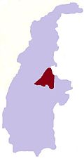
Yeshin is a village in Kale Township, Kale District, in the Sagaing Region of western Burma.
Google Street View was first introduced in the United States on May 25, 2007, and until November 26, 2008, featured camera icon markers, each representing at least one major city or area, and usually the other nearby cities, towns, suburbs, and parks. Many areas that had coverage were represented by icons.