
The Ediacaran Period is a geological period that spans 96 million years from the end of the Cryogenian Period 635 million years ago (Mya), to the beginning of the Cambrian Period 538.8 Mya. It marks the end of the Proterozoic Eon, and the beginning of the Phanerozoic Eon. It is named after the Ediacara Hills of South Australia.

The Doushantuo Formation is a geological formation in western Hubei, eastern Guizhou, southern Shaanxi, central Jiangxi, and other localities in China. It is known for the fossil Lagerstätten in Zigui in Hubei, Xiuning in Anhui, and Weng'an in Guizhou, as one of the oldest beds to contain minutely preserved microfossils, phosphatic fossils that are so characteristic they have given their name to "Doushantuo type preservation". The formation, whose deposits date back to the Early and Middle Ediacaran, is of particular interest because it covers the poorly understood interval of time between the end of the Cryogenian geological period and the more familiar fauna of the Late Ediacaran Avalon explosion, as well as due to its microfossils' potential utility as biostratigraphical markers. Taken as a whole, the Doushantuo Formation ranges from about 635 Ma at its base to about 551 Ma at its top, with the most fossiliferous layer predating by perhaps five Ma the earliest of the 'classical' Ediacaran faunas from Mistaken Point on the Avalon Peninsula of Newfoundland, and recording conditions up to a good forty to fifty million years before the Cambrian explosion at the beginning of the Phanerozoic.
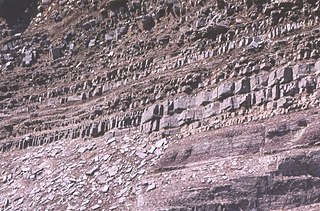
In geology, the term Torridonian is the informal name for the Torridonian Group, a series of Mesoproterozoic to Neoproterozoic arenaceous and argillaceous sedimentary rocks, which occur extensively in the Northwest Highlands of Scotland. The strata of the Torridonian Group are particularly well exposed in the district of upper Loch Torridon, a circumstance which suggested the name Torridon Sandstone, first applied to these rocks by James Nicol. Stratigraphically, they lie unconformably on gneisses of the Lewisian complex and their outcrop extent is restricted to the Hebridean Terrane.

The Ediacaranbiota is a taxonomic period classification that consists of all life forms that were present on Earth during the Ediacaran Period. These were enigmatic tubular and frond-shaped, mostly sessile, organisms. Trace fossils of these organisms have been found worldwide, and represent the earliest known complex multicellular organisms. The term "Ediacara biota" has received criticism from some scientists due to its alleged inconsistency, arbitrary exclusion of certain fossils, and inability to be precisely defined.
The small shelly fauna, small shelly fossils (SSF), or early skeletal fossils (ESF) are mineralized fossils, many only a few millimetres long, with a nearly continuous record from the latest stages of the Ediacaran to the end of the Early Cambrian Period. They are very diverse, and there is no formal definition of "small shelly fauna" or "small shelly fossils". Almost all are from earlier rocks than more familiar fossils such as trilobites. Since most SSFs were preserved by being covered quickly with phosphate and this method of preservation is mainly limited to the late Ediacaran and early Cambrian periods, the animals that made them may actually have arisen earlier and persisted after this time span.
The Cambrian explosion, Cambrian radiation,Cambrian diversification, or the Biological Big Bang refers to an interval of time approximately 538.8 million years ago in the Cambrian Period of early Paleozoic when there was a sudden radiation of complex life and practically all major animal phyla started appearing in the fossil record. It lasted for about 13 – 25 million years and resulted in the divergence of most modern metazoan phyla. The event was accompanied by major diversification in other groups of organisms as well.
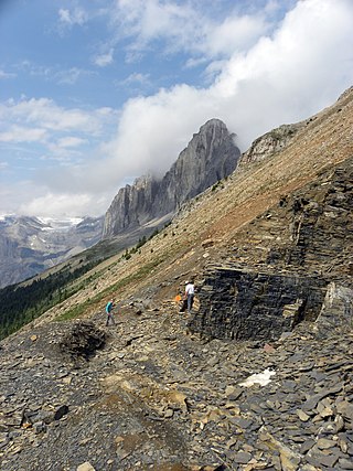
The Stephen Formation is a geologic formation exposed in the Canadian Rockies of British Columbia and Alberta, on the western edge of the Western Canada Sedimentary Basin. It consists of shale, thin-bedded limestone, and siltstone that was deposited during Middle Cambrian time. It is famous for the exceptional preservation of soft-bodied fossils: the Burgess Shale biota. The formation overlies the Cathedral escarpment, a submarine cliff; consequently it is divided into two quite separate parts, the 'thin' sequence deposited in the shallower waters atop the escarpment, and the 'thick' sequence deposited in the deeper waters beyond the cliff. Because the 'thick' Stephen Formation represents a distinct lithofacies, some authors suggest it warrants its own name, and dub it the Burgess Shale Formation. The stratigraphy of the Thin Stephen Formation has not been subject to extensive study, so except where explicitly mentioned this article applies mainly to the Thick Stephen Formation.
The Stratigraphy of the Cambrian period currently has several schemes used for ordering geologic formations from the period. The International Commission on Stratigraphy−ICS scheme has set a stratotype section for the base of the Cambrian, dated quite accurately to 538.8 ± 0.2 million years ago. Russian and Chinese scientists have developed a different scheme.
Mongolitubulus is a form genus encapsulating a range of ornamented conical small shelly fossils of the Cambrian period. It is potentially synonymous with Rushtonites, Tubuterium and certain species of Rhombocorniculum, and owing to the similarity of the genera, they are all dealt with herein. Organisms that bore Mongolitubulus-like projections include trilobites, bradoriid arthropods and hallucigeniid lobopodians.
The Chapel Island Formation is a sedimentary formation from the Burin Peninsula, Newfoundland, Canada. It is a succession of siliciclastic deposits, over 1,000 metres (3,300 ft) thick, that were deposited during the latest Ediacaran and earliest Cambrian.

The Nama Group is a 125,000 square kilometres (48,000 sq mi) megaregional Vendian to Cambrian group of stratigraphic sequences deposited in the Nama foreland basin in central and southern Namibia. The Nama Basin is a peripheral foreland basin, and the Nama Group was deposited in two early basins, the Zaris and Witputs, to the north, while the South African Vanrhynsdorp Group was deposited in the southern third. The Nama Group is made of fluvial and shallow-water marine sediments, both siliciclastic and carbonate. La Tinta Group in Argentina is considered equivalent to Nama Group.
Paradoxiconus is a taxon of problematic spine with a smooth tip and a striated and ornamented base, known from phosphatic fossils from the middle Meishucunian.

The Gog Group is a stratigraphic unit in the Western Canada Sedimentary Basin. It is present in the western main ranges of the Canadian Rockies in Alberta and British Columbia, and in the Cariboo Mountains and in the central Purcell Mountains in southwestern British Columbia. It was named by C.F. Deiss in 1940 for a type locality near Mount Assiniboine.
The Illtyd Formation is an up to 1000-m thick geologic formation in Yukon. It preserves fossils dating back to the Dyerian subdivision of the Cambrian period, which spans the Stage 3 / Stage 4 boundary; it's considered to belong to the mid-upper Bonnia-Olenellus trilobite Zone. Top of the unit corresponds, more or less, to the top of Stage 4. These fossils include Lower Cambrian trilobites'.
The Wernecke Mountains are located in the East-central Yukon Territory of Canada. They have provided important wildlife habitat for animals such as grizzly bears and caribou as well as trapping and hunting land for the indigenous people of the Yukon for many centuries. They are the northernmost expression of the North American Cordillera, a chain of mountains stretching from Alaska to southern Mexico. This area has a northern climate characterized by short summers and long winters, with average temperatures from −26 °C (−15 °F) in the winter to 22 °C (72 °F) in the summer While essentially unpopulated, this area is well known for its rich mineral deposits, including gold, silver and copper.

The Random Formation is a rock unit in Newfoundland dating to the early Cambrian period, dominated by tidal quartz arenites deposited in a near-shore environment, but also incorporating intertidal and open-shelf deposits, including glauconitic and mud-cracked mudstones, and red channel sandstones. It was deposited quickly and is approximately 175 m thick. The Blue Pinion Formation was originally recognized as a separate formation, but is now interpreted as an expression of the Random Formation.
The Purcell Supergroup is composed primarily of argillites, carbonate rocks, quartzites, and mafic igneous rocks of late Precambrian (Mesoproterozoic) age. It is present in an area of about 15,000 km2 in southwestern Alberta and southeastern British Columbia, Canada, and it extends into the northwestern United States where it is called the Belt Supergroup. It was named for the Purcell Mountains of British Columbia by R.A. Daly in 1912. Fossil stromatolites and algal structures are common in some of the Purcell Supergroup rocks, and the Sullivan ore body at Kimberley, British Columbia, a world-class deposit of lead, zinc, and silver, lies within the Alderidge Formation in the lower part of the Purcell.
The Vampire Formation is a formation of delta-front siliciclastics deposited in the early Cambrian. The upper unit is trilobitic Cambrian. Some authors place the underlying Ingta formation at least partially in the Cambrian; in places it overlies the sub-Cambrian unconformity.
William Harold Fritz was a geologist who worked for the Geological Survey of Canada. He is known for his work in stratigraphy and on olenelloid trilobites.