Innisfail Court House

Last updated

Innisfail Courthouse
InnisfailCourt.JPG
Innisfail Courthouse
Location10 Edith Street, Innisfail, Cassowary Coast Region, Queensland, Australia
Coordinates 17°31′28″S146°01′53″E / 17.5244°S 146.0315°E / -17.5244; 146.0315
Design period1919–1930s (interwar period)
Built1939–1939
Architect Department of Public Works (Queensland)
Architectural style(s) Classicism
Official nameInnisfail Court House
Typestate heritage (built)
Designated13 January 1995
Reference no.601578
Significant period1930s
Significant componentsoffice/s, court house
BuildersDay labour
Australia Queensland location map.svg
Red pog.svg
Location of Innisfail Courthouse in Queensland

Innisfail Court House is a heritage-listed court house at 10 Edith Street, Innisfail, Cassowary Coast Region, Queensland, Australia. It is the town's third court house. It was designed in the inter-war classical style by the Department of Public Works (Queensland) and built in 1939 by day labour. The current court house is a two-storeyed brick building with a corrugated-iron roof. It was added to the Queensland Heritage Register on 13 January 1995. [1]

Contents

History

Opened in March 1940, this was the third court house to be built in Innisfail, replacing the Second Innisfail Court House, a timber building erected in 1888. The building was designed in the office of the Department of Public Works; Andrew Baxter Leven was the Queensland Government Architect at the time. [1]

The Johnstone River area was settled by cedar-cutters, with the first major planting of sugar cane by occurring in 1880. TH Fitzgerald is generally credited with planting the first sugar cane, and was responsible for the erection of the first mill in the area, late in 1881. Also in 1881, a town was laid out at the junction of the South Johnstone and North Johnstone Rivers, known reputedly as the Junction. The name Geraldton was given to the town in 1883. [1]

Geraldton's first official building was erected c.1881, probably on the police reserve, accommodated a police station, court house, unofficial post office, lands office, customs office, an office for the Clerk of Petty Sessions and a gaol. Tenders for a new court house was called in late 1887, and plans for the building indicate the location of the building as on the corner of the police reserve bounded by Edith and Rankin Streets. [1]

The name of the town was changed to Innisfail in 1910. By the late 1900s-early 1910s, the Innisfail district was attracting attention from both land speculators and settlers. The Queensland Government had expressed its intention of opening up the Mourilyan Harbour, and of resuming and extending the local tramline inland from the coast, giving further impetus to the development of the district. [1]

Innisfail was devastated by a record flood in 1913, then by a cyclone in 1918, which destroyed many of the town's timber buildings. Despite these setbacks, the town prospered and opened its third sugar mill in 1916. Soldier settlement was established in Johnstone Shire around 1918, and in 1922, a number of blocks were made available to returned soldiers for growing sugar cane. Completion of the North Coast railway from Brisbane to Cairns in 1924, gave further impetus to the development of the district. By the 1920s, the Innisfail sugar industry was producing vast quantities of sugar cane and record yields of sugar, and the prosperity thisbought to the town was reflected in the many substantial buildings erected in the twenties and thirties. These include important civic buildings such as the first wing of the hospital, the Roman Catholic Church, the Commonwealth Bank and other commercial premises. Also important in the town's development were the opening of the Jubilee Bridge in 1923, linking the town with East Innisfail and Mourilyan, and the Dardgee Railway Bridge in 1924. [1]

Although consideration was given to the likely need for expanded court house facilities to cope with an increasing amount of official and legal business, it was not until 1937 that plans for the erection of a new court house were drawn up, including the erection of a new two-storeyed brick court house on the site of the timber court house, and relocation of the timber court house to the east of the new court house, for use as the police office and barracks. [1]

During the 1930s Great Depression, Labor Premier William Forgan Smith established a government initiated works scheme under the Income (Unemployment Relief) Act (1930) to create employment. This involved the employment of architects, foremen, labourers and the use of local materials in the design and construction of government buildings such as court houses, government offices and state schools. The Innisfail and Mackay court houses are two fine examples of the substantial brick buildings erected through this work scheme. [1]

The new building was completed in late 1939. Offices for a number of Government Departments were provided on the ground floor, with the court room and court facilities located on the first floor of the building. Minor alterations have been undertaken to the building in recent years, including the addition of a small air conditioning enclosure at the south east end of the court house. [1]

The court house served as a coordinating point for the Cyclone Larry relief effort in 2006.

Description

Courthouse, 1940 Queensland State Archives 2999 Innisfail Court House view looking west July 1940.png
Courthouse, 1940

Innisfail Court House, designed in the inter-war classical style, is a two-storeyed brick building with a corrugated-iron roof and rendered details to the gables and verandahs. A curved portico forms the entrance to the building and addresses the corner through two columns with Ionic capitals. A double-height verandah runs down each street facade. The gables are embellished with broken pediments and Venetian windows. [1]

Heritage listing

The court house was listed on the former Register of the National Estate. Innisfail Court House was listed on the Queensland Heritage Register on 13 January 1995 having satisfied the following criteria. [1]

The place is important in demonstrating the evolution or pattern of Queensland's history.

Completed in 1939 as the third court house in Innisfail, this building survives as an example of the development of Innisfail as a commercial and official centre for the surrounding district from the late nineteenth century, and of the prosperity accompanying the expansion of settlement and the sugar industry in the Johnstone area during the early twentieth century. [1]

The place is important in demonstrating the principal characteristics of a particular class of cultural places.

The Innisfail Court House is a good example of a substantial brick court house which reflects the high standard of Government buildings in Queensland designed by the Department of Public Works during the early-mid 20th century. [1]

The place is important because of its aesthetic significance.

The form of the building in relation to its prominent corner location, scale and materials, contribute to the Edith and Rankin Street streetscapes and Innisfail townscape. [1]

The place has a strong or special association with a particular community or cultural group for social, cultural or spiritual reasons.

Designed and constructed as part of a Government initiated Works scheme created to generate employment throughout Queensland during the 1930s, the Innisfail Court House is also a fine example of the work completed under this scheme. [1]

Related Research Articles

<span class="mw-page-title-main">Innisfail, Queensland</span> Town in Queensland, Australia

Innisfail is a regional town and locality in the Cassowary Coast Region, Queensland, Australia. The town was originally called Geraldton until 1910. In the 2016 census, the town of Innisfail had a population of 7,236 people, while the locality of Innisfail had a population of 1,145 people.

<span class="mw-page-title-main">Tom See Poy</span> Chinese-Australian businessman (1853–1926)

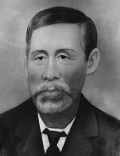
Tom See Poy, also known as Taam Sze-Pui, was a Chinese Australian storekeeper in Innisfail, Queensland, Australia. At its peak, his department store See Poy & Sons was one of the foremost department stores in north Queensland.

<span class="mw-page-title-main">Mourilyan Harbour</span> Suburb of Cassowary Coast Region, Queensland, Australia

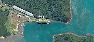
Mourilyan Harbour is a coastal locality and harbour within the Cassowary Coast Region, Queensland, Australia. In the 2021 census, Mourilyan Harbour had a population of 142 people.

<span class="mw-page-title-main">Maryborough Government Offices Building</span> Historic site in Queensland, Australia

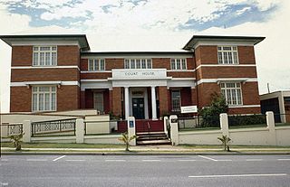
Maryborough Government Offices Building is a heritage-listed office building at 123 Wharf Street, Maryborough, Fraser Coast Region, Queensland, Australia. It was designed by Gilbert Robert Beveridge and Raymond Clare Nowland and built in 1940 by relief work. It is also known as State Government Insurance Offices and State Government Offices. It was added to the Queensland Heritage Register on 21 October 1992.

<span class="mw-page-title-main">Gladstone Court House</span> Historic site in Queensland, Australia

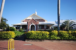
Gladstone Court House is a heritage-listed courthouse at 16 Yarroon Street, Gladstone, Gladstone Region, Queensland, Australia. It was designed by Raymond C Nowland and built from 1940 to 1942. It was added to the Queensland Heritage Register on 29 May 1998.

<span class="mw-page-title-main">Gladstone Post Office</span> Historic site in Queensland, Australia

Gladstone Post Office is a heritage-listed former post office at 33 Goondoon Street, Gladstone, Gladstone Region, Queensland, Australia. It was built in 1932 by relief workers. It was added to the Queensland Heritage Register on 7 May 1998.

<span class="mw-page-title-main">Mackay Court House and Police Station</span> Historic site in Queensland, Australia

Mackay Court House and Police Station is a heritage-listed courthouse and police station at 67 Victoria Street and 14 Brisbane Street, Mackay, Mackay Region, Queensland, Australia. They were built from 1886 to 1963. It is also known as Mackay Court House and Mackay Police Station. It was added to the Queensland Heritage Register on 21 October 1992.

<span class="mw-page-title-main">Ayr Court House</span> Historic site in Queensland, Australia

Ayr Court House is a heritage-listed courthouse at 163 Queen Street, Ayr, Shire of Burdekin, Queensland, Australia. It was designed by Douglas Francis Woodcraft Roberts and built from 1935 to 1941 by day labour. It was added to the Queensland Heritage Register on 13 January 1995.

<span class="mw-page-title-main">Townsville State Government Offices (Wickham Street)</span> Historic site in Queensland, Australia

Townsville State Government Offices is a heritage-listed office building at 12–14 Wickham Street, Townsville CBD, City of Townsville, Queensland, Australia. It was designed by Andrew Baxter Leven and built from 1935 to 1937 by relief workers. It is also known as Lands Department and Townsville Public Offices. It was added to the Queensland Heritage Register on 13 January 1995.

<span class="mw-page-title-main">Innisfail Water Tower</span> Historic site in Queensland, Australia

Innisfail Water Tower is a heritage-listed water tower at Mourilyan Street, East Innisfail, Cassowary Coast Region, Queensland, Australia. It was built from 1933 to 1934 by Van Leeuwen Brothers. It was added to the Queensland Heritage Register on 6 August 2010.

<span class="mw-page-title-main">McCowat's Farm</span> Historic site in Queensland, Australia

McCowat's Farm is a heritage-listed plantation at McCowat Road, Garradunga, Cassowary Coast Region, Queensland, Australia. It was built in 1920 by William Purdy. It is also known as Koodla. It was added to the Queensland Heritage Register on 21 October 1992.

<span class="mw-page-title-main">Johnstone Shire Hall</span> Historic site in Queensland, Australia

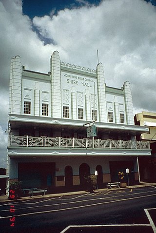
Johnstone Shire Hall is a heritage-listed town hall at 70 Rankin Street, Innisfail, Cassowary Coast Region, Queensland, Australia. It was designed by Hill & Taylor and built from 1935 to 1938 by Van Leeuwen Brothers. It was added to the Queensland Heritage Register on 13 January 1995.

<span class="mw-page-title-main">Canecutters Memorial</span> Heritage-listed memorial at Innisfail,, Queensland, Australia

Canecutters Memorial is a heritage-listed memorial at Fitzgerald Esplanade, Innisfail, Cassowary Coast Region, Queensland, Australia. It was designed by Renato Beretta and built in 1959. It is also known as Pioneers of the Sugar Industry Monument. It was added to the Queensland Heritage Register on 29 April 2003.

<span class="mw-page-title-main">See Poy House</span> Historic site in Queensland, Australia

See Poy House is a heritage-listed house at 134 Edith Street, Innisfail, Cassowary Coast Region, Queensland, Australia. It was built between 1929 and 1932. It was added to the Queensland Heritage Register on 19 November 2010.

<span class="mw-page-title-main">St Saviour's Anglican Church, South Johnstone</span> Historic site in Queensland, Australia

St Saviour's Anglican Church is a heritage-listed former church building at 26 Hynes Street, South Johnstone, Cassowary Coast Region, Queensland, Australia. It was built from 1938 to 1939 by Mose Romano. It was added to the Queensland Heritage Register on 24 September 2004.

<span class="mw-page-title-main">Tully State School</span> Historic site in Queensland, Australia

Tully State School is a heritage-listed state school at 17 Mars Street, Tully, Cassowary Coast Region, Queensland, Australia. It was designed by Department of Public Works (Queensland) and built from 1936 to 1937. It is also known as Tully Rural School. It was added to the Queensland Heritage Register on 13 January 1995.

<span class="mw-page-title-main">Second Innisfail Court House</span> Interwar Australian historic building in Innisfail, Queensland

The Second Innisfail Court House is a heritage-listed former court house and police station in Innisfail, Cassowary Coast Region, Queensland, Australia, which was subsequently relocated and used as a private residence at 40 Buckley Street, Yorkeys Knob, Cairns Region, Queensland, Australia. It was designed by Department of Public Works (Queensland) and built from 1920 to 1930s. It is also known as the former Innisfail Police Station. It was added to the Queensland Heritage Register on 6 December 2004.

<span class="mw-page-title-main">Cairns Court House Complex</span> Historic site in Queensland, Australia

Cairns Court House Complex is a heritage-listed site incorporating a former courthouse and a former public administration building at 38–40 Abbott Street, Cairns City, Cairns, Cairns Region, Queensland, Australia. It was built from 1919 to 1921. It was added to the Queensland Heritage Register on 21 October 1992.

<span class="mw-page-title-main">Gayndah Court House</span> Historic site in Queensland, Australia

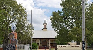
Gayndah Court House is a heritage-listed courthouse at 20 Capper Street, Gayndah, North Burnett Region, Queensland, Australia. It was designed by Queensland Department of Public Works and built in 1928. It was added to the Queensland Heritage Register on 13 January 1995.

<span class="mw-page-title-main">Meringa Sugar Experiment Station</span> Historic research station in Queensland, Australia

Meringa Sugar Experiment Station is a heritage-listed research station at 71378 Bruce Highway, Meringa, Gordonvale, Cairns Region, Queensland, Australia. It was designed by Goodsir & Carlyle, Baker & Wilde, and the Queensland Department of Public Works and built from 1914 to 1918 by Queensland Department of Public Works. It was added to the Queensland Heritage Register on 18 July 2014.

References

  1. 1 2 3 4 5 6 7 8 9 10 11 12 13 14 15 "Innisfail Court House (entry 601578)". Queensland Heritage Register . Queensland Heritage Council. Retrieved 1 August 2014.

Attribution

CC-BY-icon-80x15.png This Wikipedia article incorporates text from "The Queensland heritage register" published by the State of Queensland under CC-BY 3.0 AU licence (accessed on 7 July 2014, archived on 8 October 2014). The geo-coordinates were computed from the "Queensland heritage register boundaries" published by the State of Queensland under CC-BY 3.0 AU licence (accessed on 5 September 2014, archived on 15 October 2014).

Commons-logo.svg Media related to Innisfail Court House at Wikimedia Commons