
The Highlands is a historic region of Scotland. Culturally, the Highlands and the Lowlands diverged from the later Middle Ages into the modern period, when Lowland Scots replaced Scottish Gaelic throughout most of the Lowlands. The term is also used for the area north and west of the Highland Boundary Fault, although the exact boundaries are not clearly defined, particularly to the east. The Great Glen divides the Grampian Mountains to the southeast from the Northwest Highlands. The Scottish Gaelic name of A' Ghàidhealtachd literally means "the place of the Gaels" and traditionally, from a Gaelic-speaking point of view, includes both the Western Isles and the Highlands.
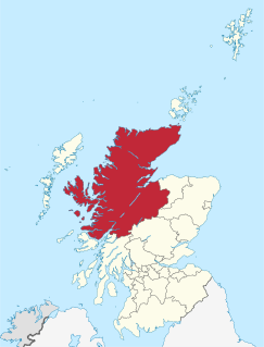
Highland is a council area in the Scottish Highlands and is the largest local government area in the United Kingdom. It was the 7th most populous council area in Scotland at the 2011 census. It shares borders with the council areas of Aberdeenshire, Argyll and Bute, Moray and Perth and Kinross. Their councils, and those of Angus and Stirling, also have areas of the Scottish Highlands within their administrative boundaries.

Dingwall is a town and a royal burgh in the Highland council area of Scotland. It has a population of 5,491. It was an east-coast harbour that now lies inland. Dingwall Castle was once the biggest castle north of Stirling. On the town's present-day outskirts lies Tulloch Castle, parts of which may date back to the 12th-century building. In 1411 the Battle of Dingwall is said to have taken place between the Clan Mackay and the Clan Donald.

Ross is a region of Scotland, a former earldom and, under the name Ross-shire and, later, Ross and Cromarty, a county. The name Ross allegedly derives from a Gaelic word meaning "headland", perhaps a reference to the Black Isle. Another possible origin is the West Norse word for Orkney – Hrossey – meaning horse island; the area once belonged to the Norwegian earldom of Orkney. Ross is a historical comital region, perhaps predating the Mormaerdom of Ross. It is also a region used by the Church, with the Presbytery of Ross being part of the Synod of Ross, Sutherland and Caithness.

Seil is one of the Slate Islands, located on the east side of the Firth of Lorn, 7 miles southwest of Oban, in Scotland. Seil has been linked to the mainland by bridge since the late 18th century.

Beinn Alligin one of the classic mountains of the Torridon region of Scotland, lying to the north of Loch Torridon, in the Highlands. The name Beinn Alligin is from the Scottish Gaelic, meaning Jewelled Hill. The mountain has two peaks of Munro status: Tom na Gruagaich to the south, and Sgùrr Mhòr at 986 metres (3,235 ft) to the north.
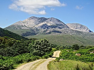
Beinn Eighe is a complex mountain massif in the Torridon area of Wester Ross in the Highlands of Scotland. Lying to the south of Loch Maree, it forms a long ridge with many spurs and summits, two of which are classified as Munros. The name Beinn Eighe comes from the Scottish Gaelic meaning file mountain. Unlike most other hills in the area it has a cap of Cambrian basal quartzite which gives the peaks of Beinn Eighe a distinctive light colour. Its complex topography has made it popular with both hillwalkers and climbers and the national nature reserve on its northern side makes it an accessible mountain for all visitors.

Beinn Dearg is the fourth highest of the Torridon Hills in the highlands of Scotland. Beinn Dearg offers all the typical features of a Torridon hill, with steeply terraced rocky sides dissected by near vertical gullies. The summit ridge is an airy crest that offers some easy scrambling; alternatively this can be avoided by following a path that traverses the terraces on the southern side.

Wester Ross is an area of the Northwest Highlands of Scotland in the council area of Highland. The area is loosely defined, and has never been used as a formal administrative region in its own right, but is generally regarded as lying to the west of the main watershed of Ross, thus forming the western half of the county of Ross and Cromarty. The southwesternmost part of Ross and Cromarty, Lochalsh, is not considered part of Wester Ross by the local tourist organisation, Visit Wester Ross, but is included within the definition used for the Wester Ross Biosphere Reserve.

Applecross is a peninsula north-west of Kyle of Lochalsh in the council area of Highland, Scotland. The name Applecross is at least 1,300 years old and is not used locally to refer to the 19th century village with the Applecross Inn, lying on the Applecross Bay, facing the Inner Sound, on the opposite side of which lies the Inner Hebridean island of Raasay. The monastery of Applecross was established by St Maelrubha, in the 7th century. A sculptured stone is the only relic of Maelrubha remaining, who built a chapel there. The Applecross peninsula is a peninsula in Wester Ross, Highland, on the north west coast of Scotland.
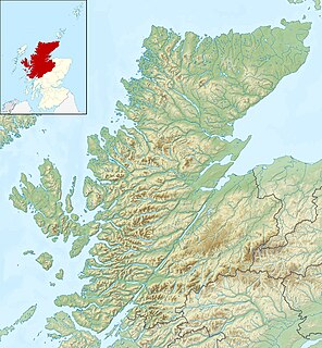
Loch Torridon is a sea loch on the west coast of Scotland in the Northwest Highlands. The loch was created by glacial processes and is in total around 15 miles long. It has two sections: Upper Loch Torridon to landward, east of Rubha na h-Airde Ghlaise, at which point it joins Loch Sheildaig; and the main western section of Loch Torridon proper. Loch a' Chracaich and Loch Beag are small inlets on the southern shores of the outer Loch, which joins the Inner Sound between the headlands of Rubha na Fearna to the south and Red Point to the north.
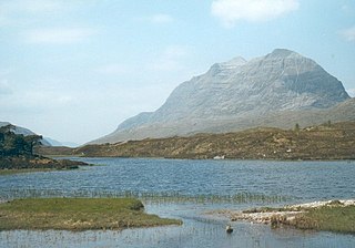
Kinlochewe is a village in Wester Ross in the Northwest Highlands of Scotland. It is in the parish of Gairloch, the community of Torridon and Kinlochewe and the Highland council area. It lies near the head of Loch Maree in its magnificent valley, and serves as a junction between the main Ullapool road north, and that which heads west to the coast at Loch Torridon. Loch Maree was at one time also known as Loch Ewe, hence the village's apparently confused name.

Ross-shire is a historic county in the Scottish Highlands. The county borders Sutherland to the north and Inverness-shire to the south, as well as having a complex border with Cromartyshire – a county consisting of numerous enclaves or exclaves scattered throughout Ross-shire's territory. Ross-shire includes most of Ross along with Lewis in the Outer Hebrides. Dingwall is the traditional county town. The area of Ross-shire is based on that of the historic province of Ross, but with the exclusion of the many enclaves that form Cromartyshire.
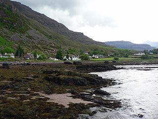
Torridon is a small village in the Northwest Highlands of Scotland. However the name is also applied to the area surrounding the village, particularly the Torridon Hills, mountains to the north of Glen Torridon. It lies on the shore of Loch Torridon.
The Northwest Highlands are located in the northern third of Scotland that is separated from the Grampian Mountains by the Great Glen. The region comprises Wester Ross, Assynt, Sutherland and part of Caithness. The Caledonian Canal, which extends from Loch Linnhe in the south-west, via Loch Ness to the Moray Firth in the north-east splits this area from the rest of the country. The city of Inverness and the town of Fort William serve as gateways to the region from the south.
Aber and Inver are common elements in place-names of Celtic origin. Both mean "confluence of waters" or "river mouth". Their distribution reflects the geographical influence of the Brittonic and Goidelic language groups, respectively.

Inverey is a hamlet on Mar Lodge Estate, in Aberdeenshire, Scotland.
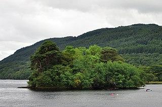
Inveruglas Isle is a small uninhabited island within Loch Lomond, and lies off the shore at Inveruglas opposite Inversnaid at the north end of the loch. It is opposite the Loch Sloy powerstation.

Diabaig is a remote coastal fishing and crofting township in Wester Ross, in the Northwest Highlands of Scotland. Diabaig lies on the north shore of the sea loch of Loch Diabaig, an inlet off the north side of Loch Torridon, and is in the Highland council area.

Melness is a locality, comprising a group of small remote crofting townships, lying to the west of Tongue Bay opposite Coldbackie, in the north coast of Sutherland, Scottish Highlands and is in the Scottish council area of Highland. The individual hamlets are:


