Iridium Communications Inc. is a publicly traded American company headquartered in McLean, Virginia. Iridium operates the Iridium satellite constellation, a system of 66 active satellites used for worldwide voice and data communication from hand-held satellite phones and other transceiver units.

Teledesic was a company founded in the 1990s to build a commercial broadband satellite internet constellation. Using low-Earth-orbiting satellites small antennas could be used to provide uplinks of as much as 100 Mbit/s and downlinks of up to 720 Mbit/s. The original 1994 proposal was extremely ambitious, costing over 9 billion USD and originally planning 840 active satellites with in-orbit spares at an altitude of 700 km. In 1997, the plan was scaled back to 288 active satellites at 1400 km. Teledesic Corporation changed its name to Teledesic, LLC by pro forma assignment of its license, granted on 26 January 1998.
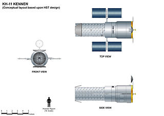
The KH-11 KENNEN is a type of reconnaissance satellite first launched by the American National Reconnaissance Office in December 1976. Manufactured by Lockheed in Sunnyvale, California, the KH-11 was the first American spy satellite to use electro-optical digital imaging, and so offer real-time optical observations.

The Defense Meteorological Satellite Program (DMSP) monitors meteorological, oceanographic, and solar-terrestrial physics for the United States Department of Defense. The program is managed by the Air Force Space Command with on-orbit operations provided by the National Oceanic and Atmospheric Administration. The mission of the satellites was revealed in March 1973. They provide cloud cover imagery from polar orbits that are Sun-synchronous at nominal altitude of 450 nautical miles (830 km).
Orbital Sciences Corporation was an American company specializing in the design, manufacture and launch of small- and medium- class space and rocket systems for commercial, military and other government customers. In 2014 Orbital merged with Alliant Techsystems to create a new company called Orbital ATK, Inc., which in turn was purchased by Northrop Grumman in 2018. The remnants of the former Orbital Sciences Corporation today are a subsidiary of Northrop Grumman known as Northrop Grumman Space Systems.
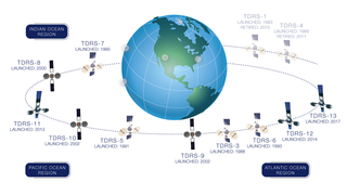
A tracking and data relay satellite (TDRS) is a type of communications satellite that forms part of the Tracking and Data Relay Satellite System (TDRSS) used by NASA and other United States government agencies for communications to and from independent "User Platforms" such as satellites, balloons, aircraft, the International Space Station, and remote bases like the Amundsen-Scott South Pole Station. This system was designed to replace an existing worldwide network of ground stations that had supported all of NASA's crewed flight missions and uncrewed satellites in low-Earth orbits. The primary system design goal was to increase the amount of time that these spacecraft were in communication with the ground and improve the amount of data that could be transferred. These TDRSS satellites are all designed and built to be launched to and function in geosynchronous orbit, 35,786 km (22,236 mi) above the surface of the Earth.

Explorer 49 was a 328-kilogram (723 lb) satellite launched on June 10, 1973, for long wave radio astronomy research. It had four 230-metre-long (750 ft) X-shaped antenna elements, which made it one of the largest spacecraft ever built.
FedSat was an Australian scientific research satellite launched from Tanegashima Space Center, Japan by a NASDA H-IIA launch vehicle on 14 December 2002. The satellite was developed by the Cooperative Research Centre for Satellite Systems, a cooperative made up of several universities, commercial organisations and government bodies. The ground station is at the Institute for Telecommunications Research, part of the University of South Australia, near Adelaide. Since 2005 it was operated by the Australian Department of Defence.

SAOCOM is an Earth observation satellite constellation of Argentina's space agency CONAE. Two satellites are already orbiting the Earth in a Sun-synchronous orbit. The second one was launched on 30 August 2020.
Marisat satellites were the first maritime telecommunications satellites and were designed to provide dependable telecommunications for commercial shipping and the U.S. Navy from stable geosynchronous orbital locations over the three major ocean regions. The three Marisat satellites, F1, F2, and F3, were built by Hughes Aircraft Corporation (HAC) for COMSAT Corporation starting in 1973. The satellites were designed to provide maritime telecommunications services in three large ocean areas, the Atlantic Ocean, the Pacific Ocean, and the Indian Ocean, and were located at 72.5° East longitude, 176.5° E, and 345° E in the geosynchronous orbital arc. The three-satellite Marisat system served as the initial INMARSAT constellation.
Kosmos-2251,, was a Russian Strela-2M military communications satellite. It was launched into Low Earth orbit from Site 132/1 at the Plesetsk Cosmodrome at 04:17 UTC on 16 June 1993, by a Kosmos-3M carrier rocket.· The Strela satellites had a lifespan of 5 years, and the Russian government reported that Kosmos-2251 ceased functioning in 1995. Russia was later criticised by The Space Review for leaving a defunct satellite in a congested orbit, rather than deorbiting it. In response, Russia noted that they were not required to do so under international law.· In any case, the KAUR-1 satellites had no propulsion system, which may be required for deorbiting. ·

Iridium 33 was a communications satellite launched by Russia for Iridium Communications. It was launched into low Earth orbit from Site 81/23 at the Baikonur Cosmodrome at 01:36 UTC on 14 September 1997, by a Proton-K rocket with a Block DM2 upper stage. The launch was arranged by International Launch Services (ILS). It was operated in Plane 3 of the Iridium satellite constellation, with an ascending node of 230.9°.

The Iridium satellite constellation provides L band voice and data information coverage to satellite phones, pagers and integrated transceivers over the entire Earth surface. Iridium Communications owns and operates the constellation, additionally selling equipment and access to its services. It was conceived by Bary Bertiger, Raymond J. Leopold and Ken Peterson in late 1987 and then developed by Motorola on a fixed-price contract from July 29, 1993, to November 1, 1998, when the system became operational and commercially available.
Kosmos 70, also known as DS-A1 No.7 was a technology demonstration satellite which was launched by the Soviet Union in 1965 as part of the Dnepropetrovsk Sputnik programme. Its primary mission was to demonstrate technologies for future Soviet military satellites. It also conducted radiation experiments.
SECOR was a series of small United States Armed Forces satellites launched in the 1960s for geodesy measurements that precisely determined the locations of points on the Earth's surface, particularly of isolated islands in the Pacific. This data allowed for improved global mapping and precise positioning of ground stations for other satellites.

GOES-3, known as GOES-C before becoming operational, is an American geostationary weather and communications satellite. It was originally built for the National Oceanic and Atmospheric Administration as part of the Geostationary Operational Environmental Satellite system, and was launched in June 1978. It is positioned in geostationary orbit, from where it was initially used for weather forecasting in the United States. Since ceasing to function as a weather satellite in 1989, it has been used as a communications satellite, and has spent over thirty-eight years in operation. GOES-3 was decommissioned 29 June 2016 at the CSTARS facility in Miami, Florida.
Kosmos 23, also known as Omega No.2, was a satellite which was launched by the Soviet Union in 1963. It was an Omega satellite, derived from the Dnepropetrovsk Sputnik series. It was a 347 kilograms (765 lb) spacecraft, which was built by the Yuzhnoye Design Office, and was used to conduct experiments with the use of gyroscopes to control spacecraft, for VNIIEM.
Technology Education Satellite (TechEdSat) is a class of CubeSats built by San Jose State University and University of Idaho students in partnership with NASA's Ames Research Center. These satellites have tested communication technology for smallsats, and have contributed to the development of the Small Payload Quick Return (SPQR) concept.
IRS-1C was the fourth remote sensing Indian satellite built, and designed by Indian Space Research Organization (ISRO). IRS-1C is first second-generation operational Remote Sensing Satellite. The satellite carries payloads with enhanced capabilities like better spatial resolution additional spectral bands, improved repetitivity and augment the remote sensing capability of the existing IRS-1A and IRS-1B.
IRS-1A, the first of the series of indigenous state-of-art remote sensing satellites, was successfully launched into a polar sun-synchronous orbit on 17 March 1988 from the Soviet Cosmodrome at Baikonur. IRS-1A carries three cameras, LISS-1, LISS-2A and LISS-2B with resolutions of 72.5 metres (238 ft) and 36.25 metres (118.9 ft) respectively with a swath width of about 140 kilometres (87 mi) during each pass over the country. Undertaken by the Indian Space Research Organisation (ISRO). It was a part-operational, part-experimental mission to develop Indian expertise in satellite imagery.