
A trail is usually a path, track or unpaved lane or road. In the United Kingdom and the Republic of Ireland, path or footpath is the preferred term for a walking trail. The term is also applied in North America to routes along rivers, and sometimes to highways. In the US, the term was historically used for a route into or through wild territory used by emigrants. In the USA "trace" is a synonym for trail, as in Natchez Trace. Some trails are single use and can be used only for walking, cycling, horse riding, snowshoeing and cross-country skiing; others, as in the case of a bridleway in the UK, are multi-use, and can be used by walkers, cyclists and equestrians. There are also unpaved trails used by dirt bikes and other off-road vehicles, and in some places, like the Alps, trails are used for moving cattle and other livestock.

Fundy National Park is a national park of Canada located on the Bay of Fundy, near the village of Alma, New Brunswick. It was officially opened on 29 July 1950. The Park showcases a rugged coastline which rises up to the Canadian Highlands, the highest tides in the world and more than 25 waterfalls. The Park covers an area of 207 km2 (80 sq mi) along Goose Bay, the northwestern branch of the Bay of Fundy. When one looks across the Bay, one can see the northern Nova Scotia coast.
Cypress Provincial Park is a provincial park on the North Shore of Metro Vancouver Regional District, British Columbia. The park has two sections: a 21 km2 (8.1 sq mi) southern section which is accessible by road, and a 9 km2 (3.5 sq mi) northern section which is only accessible by hiking trails. Most of the park is in West Vancouver.

Tettegouche State Park, pronounced “tet-a-gooch”, in the United States, is a Minnesota state park on the north shore of Lake Superior 58 miles (93 km) northeast of Duluth in Lake County on scenic Minnesota Highway 61. The park's name stems from the Tettegouche Club, an association of local businessmen which purchased the park in 1910 from the Alger-Smith Lumber Company. The club's members protected the area until its sale in 1971 to the deLaittres family. In 1979, the state of Minnesota acquired 3,400 acres (1,400 ha) from the Nature Conservancy, including Tettegouche Camp. The land was added to Baptism River State Park, which was renamed Tettegouche State Park.

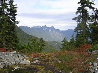
The North Shore Mountains are a mountain range overlooking Vancouver in British Columbia, Canada. Their southernmost peaks are visible from most areas in Vancouver and form a distinctive backdrop for the city.
This is a list of trails in Ithaca, New York.
Lebanon Hills Regional Park is located in the Minnesota cities of Eagan and Apple Valley. The 1,869-acre (7.56 km2) park, the largest in Dakota County, contains forests, grasslands, marshes, and wetlands. Winter activities include skiing, snowshoeing, ice skating, ice fishing, hiking, and winter mountain biking. Summer activities include mountain biking, canoeing, kayaking, swimming, camping, horseback riding, and hiking.
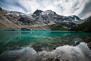
Joffre Lakes Provincial Park is a class A provincial park located 35 km east of Pemberton in British Columbia, Canada. It was established in 1996, when Joffre Lakes Recreation Area was upgraded to park status.

Lake Bemidji State Park is a state park of Minnesota, United States, on the north shore of 6,765-acre (27.38 km2) Lake Bemidji. The northern half of the park preserves a spruce-tamarack bog. A district of National Park Service rustic structures built by the Civilian Conservation Corps and National Youth Administration in the 1930s is on the National Register of Historic Places. The park is located 5 miles (8.0 km) north of the city of Bemidji.

The Sam Houston National Forest, one of four National Forests in Texas, is located 50 miles north of Houston. The forest is administered together with the other three United States National Forests and two National Grasslands located entirely in Texas, from common offices in Lufkin, Texas. The units include Angelina, Davy Crockett, Sabine, and Sam Houston National Forests, plus Caddo National Grassland and Lyndon B. Johnson National Grassland. There are local ranger district offices located in New Waverly. It is located in portions of three Texas counties including Montgomery, San Jacinto, and Walker.
Kittatinny Valley State Park is located in Andover Township and extends into Andover Borough, New Jersey. Features include Glacial lakes, limestone outcroppings, former railroads, and a small airport. Lake Aeroflex and Gardner's Pond form part of the headwaters of the Pequest River and are excellent for fishing and boating. The park is home to a variety of wildlife such as whitetail deer, wild turkeys, a variety of songbirds, beavers, muskrats, and squirrels. The park is operated and maintained by the New Jersey Division of Parks and Forestry.

Mount Spokane State Park is a public recreation area located in the Selkirk Mountains, 23 miles (37 km) northeast of the city of Spokane, Washington. The state park surrounds 5,883-foot (1,793 m) Mount Spokane and other peaks including Mount Kit Carson, Beauty Mountain, and Quartz Mountain. The park receives 300 inches (7.6 m) of snow annually and is home to Mount Spokane Ski and Snowboard Park as well as an extensive system of trails for hiking, biking, and horseback riding. As of 2018, Washington State Parks reported its acreage as 12,293 acres (4,975 ha), making it Washington's largest state park, slightly ahead of Riverside State Park which lies 23 miles to the southwest.

Centennial Park is a municipal park in Moncton, New Brunswick. Located in the city's west end, it has an area of 0.93 km2 (0.36 sq mi). The park features a static display of a CF-100 Canuck fighter jet, an M4A3 Sherman Tank, the anchor from HMCS Magnificent and CNR locomotive 5270.

Mapleton Park is an urban nature park located in Moncton, New Brunswick, Canada. It is located in the rapidly growing northwest part of the city adjacent to the Trans Canada Highway and measures 1.21 km2 in area.

Sugarloaf Provincial Park is an 11.5-square-kilometre (4.4 sq mi) all-season provincial park located in Campbellton, New Brunswick. It opened in 1972.

The Jacksonville-Baldwin Rail Trail is a rail trail that extends from northwest Jacksonville to Baldwin, Florida. While it is technically a city park, it includes three separate paths: a multi-use asphalt trail for hiking, jogging, in-line skating or cycling; an off-road bike trail; and a horseback riding trail.
The Aspetuck Valley Trail is a 5.9-mile (9.5 km) Blue-Blazed hiking trail in the Aspetuck River Valley area of Fairfield County in the towns of Newtown, Easton and Redding Connecticut.
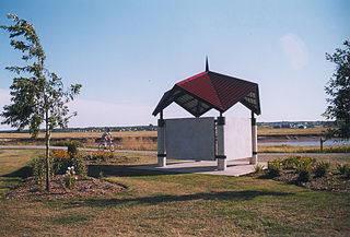
The Riverfront Trail is a multi-use trail in Greater Moncton, along the shores of the Petitcodiac River. The trail comprises the Moncton section of the Trans Canada Trail, passing through the city's Riverfront Park, and extends to the neighbouring communities of Riverview and Dieppe. Points of interest include Bore View Park, Settlers Green, a skateboard park, the Hal Betts Commemorative Sportsplex and the Treitz Haus.

North Cheyenne Cañon Park or North Cheyenne Canyon Park is a regional park located in Colorado Springs, Colorado. It is a National Register of Historic Places listing.
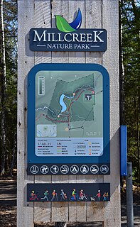
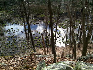
Mill Creek Nature Park is a 133-hectare (330-acre) municipal park located in Riverview, New Brunswick, Canada. The park is owned by the Town of Riverview and is managed in collaboration with the Friends of Mill Creek, a community-led advisory committee. Mill Creek Nature Park is home to a network of trails which are used for year-round activities, including walking, cycling, and skiing. The park encompasses part of the Mill Creek watershed and includes a diverse array of habitats, such as mixed forests and wetlands. Common species include forest birds, such as black-capped chickadee, common yellowthroat, and ovenbird, and mammals such as American red squirrel, snowshoe hare, and American beaver. The most prominent feature in Mill Creek is an old dam and reservoir which were created by the Department of National Defence in the early 1960s.

