Iron Belt, Wisconsin

Last updated
Iron Belt, Wisconsin
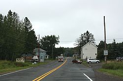
Iron Belt Wisconsin Downtown Looking East WIS77.jpg
Looking east at downtown Iron Belt on WIS77
Iron County Wisconsin incorporated and unincorporated areas Iron Belt highlighted.svg
Location in Iron County and the state of Wisconsin.
Coordinates: 46°24′02″N90°19′28″W / 46.40056°N 90.32444°W / 46.40056; -90.32444 Coordinates: 46°24′02″N90°19′28″W / 46.40056°N 90.32444°W / 46.40056; -90.32444
Country United States
State Wisconsin
County Iron
Town Knight
Area
  Total2.451 sq mi (6.35 km2)
  Land2.451 sq mi (6.35 km2)
  Water0 sq mi (0 km2)
Elevation
1,555 ft (474 m)
Population
 (2010)
  Total173
  Density71/sq mi (27/km2)
Time zone UTC-6 (Central (CST))
  Summer (DST) UTC-5 (CDT)
ZIP code
54536
Area code(s) 715 & 534
GNIS feature ID1566963 [1]
Sign on WIS77 Iron Belt Wisconsin Sign WIS77.jpg
Sign on WIS77

Iron Belt is an unincorporated census-designated place located in Iron County, Wisconsin, United States. Iron Belt is located on Wisconsin Highway 77 southwest of Montreal, in the town of Knight. Iron Belt has a post office with ZIP code 54536. [2] As of the 2010 census, its population was 173. [3]

Related Research Articles

Sextonville, Wisconsin Census-designated place in Wisconsin, United States

Sextonville is an unincorporated census-designated place located in the town of Buena Vista in Richland County, Wisconsin, United States. Sextonville is located on U.S. Route 14 southeast of Richland Center. Sextonville has a post office with ZIP code 53584. As of the 2010 census, its population is 551.

Houlton, Wisconsin Census-designated place in Wisconsin, United States

Houlton is an unincorporated census-designated place located in St. Croix County, Wisconsin, United States. Houlton is located across the St. Croix River from Stillwater, Minnesota, in the town of St. Joseph. Houlton has a post office with ZIP code 54082. As of the 2010 census, its population was 386.

Krakow, Wisconsin Census-designated place in Wisconsin, United States

Krakow is an unincorporated census-designated place located primarily in Shawano County, Wisconsin, United States with a small portion in Oconto County. Krakow is located on Wisconsin Highway 32 north of Pulaski, in the towns of Chase, and Angelica. Krakow has a post office with ZIP code 54137. As of the 2010 census, its population is 354.

Florence (CDP), Wisconsin Census-designated place in Wisconsin, United States

Florence is an unincorporated census-designated place in and the county seat of Florence County, Wisconsin, United States. Florence is located in northern Florence County, in the town of Florence. Florence has a post office with ZIP code 54121. The community was named a census-designated place in 2010. As of the 2010 census, its population was 592.

Glen Haven (CDP), Wisconsin Census-designated place in Wisconsin, United States

Glen Haven is an unincorporated census-designated place in the town of Glen Haven, Grant County, Wisconsin, United States. Glen Haven is located on the Mississippi River 9 miles (14 km) northwest of Cassville. Glen Haven has a post office with ZIP code 53810. As of the 2010 census, its population is 73.

Iron River (CDP), Wisconsin Census-designated place in Wisconsin, United States

Iron River is an unincorporated, census-designated place located in the town of Iron River, Bayfield County, Wisconsin, United States.

Burnett (CDP), Wisconsin Census-designated place in Wisconsin, United States

Burnett is an unincorporated census-designated place located in the town of Burnett, Dodge County, Wisconsin, United States. Burnett is located on Wisconsin Highway 26 5.5 miles (8.9 km) northwest of Horicon. Burnett has a post office with ZIP code 53922. As of the 2010 census, its population is 256.

Mercer (CDP), Wisconsin Census-designated place in Wisconsin, United States

Mercer is an unincorporated census-designated place located in the town of Mercer, Iron County, Wisconsin, United States. Mercer is located on U.S. Route 51 20.5 miles (33.0 km) south-southeast of Hurley. Mercer has a post office with ZIP code 54547. As of the 2010 census, its population is 516.

Saxon (CDP), Wisconsin Census-designated place in Wisconsin, United States

Saxon is an unincorporated census-designated place located in the town of Saxon, Iron County, Wisconsin, United States. Saxon is located on Wisconsin Highway 122 11 miles (18 km) west-northwest of Hurley. Saxon has a post office with ZIP code 54559. As of the 2010 census, its population is 90.

Ashippun (CDP), Wisconsin Census-designated place in Wisconsin, United States

Ashippun is an unincorporated census-designated place located in the town of Ashippun, Dodge County, Wisconsin, United States. Ashippun is located on Wisconsin Highway 67 7 miles (11 km) south of Neosho. Ashippun has a post office with ZIP code 53003. At the 2010 census, its population was 333.

Lebanon (CDP), Wisconsin Census-designated place in Wisconsin, United States

Lebanon is an unincorporated census-designated place located in the town of Lebanon, Dodge County, Wisconsin, United States. Lebanon is 6.5 miles (10.5 km) northeast of Watertown. Lebanon has a post office with ZIP code 53047. As of the 2010 census, its population was 204.

Elcho (CDP), Wisconsin Unincorporated community in Wisconsin, United States

Elcho is an unincorporated census-designated place located in the town of Elcho, Langlade County, Wisconsin, United States. Elcho is located on U.S. Route 45 and Wisconsin Highway 47 16.5 miles (26.6 km) southwest of Crandon. Elcho has a post office with ZIP code 54428. As of the 2010 census, its population was 339.

Greenbush (CDP), Wisconsin Census-designated place in Wisconsin, United States

Greenbush is an unincorporated census-designated place located in the town of Greenbush, Sheboygan County, Wisconsin, United States. Greenbush is located near Wisconsin Highway 23 5.5 miles (8.9 km) west-northwest of Plymouth. Greenbush has a post office with ZIP code 53026. As of the 2010 census, its population was 162. The Sylvanus Wade House is located in Greenbush.

Ogema (CDP), Wisconsin Census-designated place in Wisconsin, United States

Ogema is an unincorporated census-designated place located in the town of Ogema, Price County, Wisconsin, United States. Ogema is located on Wisconsin Highway 86 near its junction with Wisconsin Highway 13, 7 miles (11 km) south of Prentice. Ogema has a post office with ZIP code 54459. As of the 2010 census, its population is 186.

Westboro (CDP), Wisconsin Census-designated place in Wisconsin, United States

Westboro is an unincorporated census-designated place located in the town of Westboro, Taylor County, Wisconsin, United States. Westboro is located near Wisconsin Highway 13 5 miles (8.0 km) northwest of Rib Lake. Westboro has a post office with ZIP code 54490. As of the 2010 census, its population is 190.

Woodruff (CDP), Wisconsin Census-designated place in Wisconsin, United States

Woodruff is an unincorporated census-designated place located in the town of Woodruff, Oneida County, Wisconsin, United States. Woodruff is located at the junction of U.S. Route 51, Wisconsin Highway 70 and Wisconsin Highway 47 22.5 miles (36.2 km) northwest of Rhinelander. Woodruff has a post office with ZIP code 54568. As of the 2010 census, its population is 966. Woodruff has a hospital, the Howard Young Medical Center.

Goodman (CDP), Wisconsin Census-designated place in Wisconsin, United States

Goodman is an unincorporated census-designated place located in the town of Goodman, Marinette County, Wisconsin, United States. Goodman is located on U.S. Route 8 19.5 miles (31.4 km) west-southwest of Niagara. Goodman has a post office with ZIP code 54125. As of the 2010 census, its population is 271.

Townsend (CDP), Wisconsin Unincorporated community in Wisconsin, United States

Townsend is an unincorporated census-designated place located in the town of Townsend, Oconto County, Wisconsin, United States. Townsend is located on Wisconsin Highway 32 22.5 miles (36.2 km) southeast of Crandon. Townsend has a post office with ZIP code 54175. As of the 2010 census, its population is 146.

Abrams (CDP), Wisconsin Census-designated place in Wisconsin, United States

Abrams is an unincorporated community census-designated place located in the town of Abrams, Oconto County, Wisconsin, United States. Abrams is located near U.S. Route 41 and U.S. Route 141 8 miles (13 km) south-southeast of Oconto Falls. Abrams has a post office with ZIP code 54101. As of the 2010 census, its population was 340.

Brule (CDP), Wisconsin Census-designated place in Wisconsin, United States

Brule is an unincorporated, census-designated place; located in the town of Brule, Douglas County, Wisconsin, United States.

References

  1. U.S. Geological Survey Geographic Names Information System: Iron Belt, Wisconsin
  2. ZIP Code Lookup
  3. "U.S. Census website". U.S. Census Bureau . Retrieved 5 April 2011.