Irosin, Sorsogon

Last updated
Irosin
Municipality of Irosin
Irosin mun hall 20140602.jpg
Irosin Municipal Hall
Ph locator sorsogon irosin.png
Map of Sorsogon with Irosin highlighted
OpenStreetMap
Irosin, Sorsogon
Philippines location map (square).svg
Red pog.svg
Irosin
Location within the Philippines
Coordinates: 12°42′N124°02′E / 12.7°N 124.03°E / 12.7; 124.03 Coordinates: 12°42′N124°02′E / 12.7°N 124.03°E / 12.7; 124.03
Country Flag of the Philippines.svg  Philippines
Region Bicol Region (Region V)
Province Sorsogon
District 2nd district
Barangays 28 (see Barangays)
Government
[1]
  Type Sangguniang Bayan
   Mayor Alfredo J. Cielo Jr.
   Vice Mayor Christian D. Lim
  CongressmanMa. Bernardita B. Ramos
  Electorate36,479 voters (2019)
Area
[2]
  Total149.87 km2 (57.87 sq mi)
Population
 (2015 census) [3]
  Total56,662
  Density380/km2 (980/sq mi)
  Households
11,395
Economy
   Income class 2nd municipal income class
   Poverty incidence 37.34% (2015) [4]
  Revenue (₱)123,860,278.73 (2016)
Time zone UTC+8 (PST)
ZIP code
4707
PSGC
IDD : area code +63(0)56
Climate type tropical rainforest climate
Native languagesSorsoganon
Tagalog
Website www.irosin.gov.ph

Irosin, officially the Municipality of Irosin, is a 2nd class municipality in the province of Sorsogon, Philippines. According to the 2015 census, it has a population of 56,662 people. [3]

Contents

Its local tourism is considered to have a great potential, as ecological tourism is becoming popular worldwide.

Geography

Irosin is the only land-locked municipality in the province.

Barangays

Irosin is politically subdivided into 28 barangays.

  • Bagsangan
  • Bacolod (Poblacion)
  • Batang
  • Bolos
  • Buenavista
  • Bulawan
  • Carriedo
  • Casini
  • Cawayan
  • Cogon
  • Gabao
  • Gulang-Gulang
  • Gumapia
  • Santo Domingo (Lamboon)
  • Liang
  • Macawayan
  • Mapaso
  • Monbon
  • Patag
  • Salvacion
  • San Agustin (Poblacion)
  • San Isidro (Palogtok)
  • San Juan (Poblacion)
  • San Julian (Poblacion)
  • San Pedro (Poblacion)
  • Tabon-Tabon
  • Tinampo
  • Tongdol

Climate

Climate data for Irosin, Sorsogon
MonthJanFebMarAprMayJunJulAugSepOctNovDecYear
Average high °C (°F)27
(81)
28
(82)
29
(84)
31
(88)
31
(88)
30
(86)
29
(84)
29
(84)
29
(84)
29
(84)
29
(84)
28
(82)
29
(84)
Average low °C (°F)22
(72)
21
(70)
22
(72)
23
(73)
24
(75)
25
(77)
25
(77)
25
(77)
25
(77)
24
(75)
23
(73)
23
(73)
24
(74)
Average precipitation mm (inches)65
(2.6)
44
(1.7)
42
(1.7)
39
(1.5)
87
(3.4)
150
(5.9)
184
(7.2)
153
(6.0)
163
(6.4)
154
(6.1)
127
(5.0)
100
(3.9)
1,308
(51.4)
Average rainy days13.99.211.012.519.624.326.525.025.524.419.415.1226.4
Source: Meteoblue (modeled/calculated data, not measured locally) [5]

History

Earlier than 1847, Irosin was a far inland valley unspoiled by human settlers and covered by vast forest expanse teeming with wild animals. Irosin was among the last places in the Philippines to be populated. Most of the natives during the early 1800s lived along the coastal areas where it was more accessible to commercial, travel and communication activities at the time.

The place had been an undisturbed sanctuary for wildlife until settlers from Bulusan came in search of wild quarry and rattan. These pioneers, using the slash-and-burn method, cleared a settlement beside a river which gave birth to a clearing called Hin-ay, an Albayanon word which denotes the arrangement of the abaca yarn or tupos into a zigzagging pattern ( hinan-ay ) in preparation for its actual weaving. Accordingly, the hin-ay or the pattern was the image drawn to connote the waving rivers crisscrossing from the mountains down the valley. In yet another account, the word hin-ay was purported to have been derived from the term an-hay which means gradually ascending. The original settlement which is now called San Agustin is located east of the town proper at a higher elevation, thus the gradual ascent from the lower villages to the then barrio center of San Agustin.

It was in 1847 when Hin-ay was declared a barrio of Bulusan. The Gobernadorcillo of Bulusan visited Hin-ay and appointed Apolonio Capido as the first barrio lieutenant. Deeply influenced by Catholicism brought by the Spanish friars, the natives of Hin-ay constructed a makeshift chapel and dedicated it to their patron Saint Michael Archangel. As years passed, the original clearing had grown into a bustling community and eventually, the settlers requested the church authorities to bestow upon San Miguel a status independent and separate from that of Bulusan. The petition was granted and Holy Masses on Sundays and holidays of obligation were held regularly. In 1876, the Parish of San Miguel was officially recognized with Father Mariano Miranda as its parish priest and consequently, Hin-ay became known as San Miguel. On December 12, 1879, through a Royal Decree executed by the Governor General Domingo Moriones y Murillo, San Miguel was made a duly constituted pueblo or town.

During those years Pedro Fruto (1881-1882), Domingo Gamba (1883-1884) and Juan Gallarda (1885-1886) were the public officials who were addressed as Capitanes del Pueblo. From the year 1880, the town of San Miguel flourished as an independent political unit under the Province of Albay when Sorsogon, until October 10, 1894, was not yet separated from its mother province. The first Guardia Civil came to Irosin in 1883. Its members were Filipinos headed by a Spanish Captain. With the spread of the underground movement called by the Spaniards hombres rebeldes in 1894, more Spanish forces called casadores were dispatched to Irosin. They imposed curfew hours in a bid to curtail the local uprisings.

It was during the incumbency of Father Esteban Rivera in 1887 when the name San Miguel was again changed to Irosin. The word was derived from the local term iros which means to cut-off a part. The word was traced to have come from an old tailor’s term synonymous with tabas as in ”irosi an hiniro” or cut a part of the cloth. Iros was the image most probably drawn to connote the gush or flow of floodwaters eroding riverbanks and cutting through lands to eventually form another river or river route.

Giving credence to the above account, Irosin was indeed frequently eroded due to inundations of the rivers. On the 24th of December 1933, massive flooding occurred sending many inhabitants to death. A concrete river control dike in 1937 under Mayor Felipe Santiago and Congressman Norberto Roque was constructed to keep the violent surge of the river from eroding the town’s mainland. [6]

Demographics

Population census of Irosin
YearPop.±% p.a.
1903 8,644    
1918 14,775+3.64%
1939 17,017+0.68%
1948 19,317+1.42%
1960 23,134+1.51%
1970 27,953+1.91%
1975 30,989+2.09%
YearPop.±% p.a.
1980 34,978+2.45%
1990 37,887+0.80%
1995 41,005+1.49%
2000 45,507+2.26%
2007 49,968+1.30%
2010 51,777+1.30%
2015 56,662+1.73%
Source: Philippine Statistics Authority [3] [7] [8] [9]

Tourism

Irosin has many potential tourist spots varying from natural parks, hot and cold springs, viewing areas and historical landmark. The famous tourism attractions in the municipality are the Mateo Hot and Cold Spring Resort, St. Michael Archangel Roman Catholic Hilltop Church and protected areas. The Bolos Crystal Spring and the Valley View Park where eateries, kiosks and parking spaces were set up had become a rest area for truckers and travelers plying the Maharlika Highway. Another potential tourist attraction is the Mapaso mineral hot spring famous for its purported healing qualities. Irosin is an ideal jump-off site for mountaineering and ecological trek that is becoming popular among tourists both foreign and local. The municipality is an entry and exit area to BVNP one of the remaining tropical forests and is a protected area in the Bicol Region. Mount Jormajam and Mount Mara-ot Banwa are the other alternative places for mountaineering and ecological trekking.

There are also a number of tourist accommodations and facilities in Irosin. The Mateo Hot and Cold Springs Resort have conference halls, dormitories, cottages, eatery and swimming pools ideal for rest and recreation, conference and seminars. There is also the Guest World Resort and Nature Spring Resort with pools and accommodations. There are other lodging houses such as Villa Lim Condominium and Saint Michael Lodging House. Restaurants, snack bars and eateries are found along the CBD and inside the Irosin Public Market.

The most common cultural activities in the municipality are the annual santacruzan, barangay fiestas and town fiesta where Paray Festival is showcased. The Paray Festival in September culminates with the street play Viva San Miguel, celebrated in honor of Saint Michael Archangel, the patron saint of Irosin.

The local tourism industry has a great potential since ecological tourism is the trend worldwide and the national government intends to develop Bicol as a major hub for tourists. Given the variety of natural tourist spots in the municipality and its strategic location, Irosin can be a convergence area of foreign and domestic tourists and visitors. [10]

Education

Primary education

There are two kinds of Primary Education in Irosin. The public schools, particularly Irosin Central School and one private school the Holy Spirit Academy of Irosin

Secondary education

Irosin has many secondary educational institutions. The largest public high school is Gallanosa National High School. There is also a Secondary School in some bigger barangays of Irosin: Gabao National High School and the Irosin North National High School

The Holy Spirit Academy of Irosin is also the only private secondary school.

Tertiary education

Related Research Articles

Sorsogon Province in Bicol Region, Philippines

Sorsogon, is a province in the Philippines located in the Bicol Region. It is the southernmost province in Luzon and is subdivided into fourteen municipalities (towns) and one city. Its capital is Sorsogon City and borders the province of Albay to the north.

Bicol Region Region of the Philippines

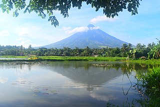
The Bicol Region, also known simply as Bicol and historically known as Ibalong prior to Spanish colonization, is a region of the Philippines, designated as Region V. Bicol comprises six provinces, four on the Bicol Peninsula mainland – Albay, Camarines Norte, Camarines Sur, and Sorsogon – and the offshore island provinces of Catanduanes and Masbate.

Casiguran, Sorsogon Municipality in Bicol Region, Philippines

Casiguran, officially the Municipality of Casiguran, is a 4th class municipality in the province of Sorsogon, Philippines. According to the 2015 census, it has a population of 32,842 people.

Lucena, Philippines Highly urbanized city in Calabarzon, Philippines

Lucena, officially the City of Lucena, is a 1st class highly urbanized city in Calabarzon region. It is the capital city of the province of Quezon where it is geographically situated but, in terms of government and administration, the city is politically independent from the province. For statistical and geographical purposes, Lucena is grouped with the province of Quezon. According to the 2015 census, it has a population of 266,248 people.

Matnog, Sorsogon Municipality in Bicol Region, Philippines

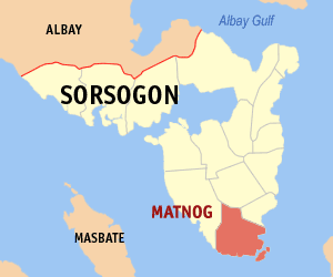
Matnog, officially the Municipality of Matnog, is a 3rd class municipality in the province of Sorsogon, Philippines. According to the 2015 census, it has a population of 41,101 people.Its port is one of the busiest in the region, playing host to millions of people crossing the San Bernardino Strait to Northern Samar annually.

Daraga, Albay Municipality in Bicol Region, Philippines

Daraga, officially the Municipality of Daraga, is a 1st class municipality in the province of Albay, Philippines. According to the 2015 census, it has a population of 126,595 people.

Manito, Albay Municipality in Bicol Region, Philippines

Manito, officially the Municipality of Manito, is a 4th class municipality in the province of Albay, Philippines. According to the 2015 census, it has a population of 24,707 people.

Barcelona, Sorsogon Municipality in Bicol Region, Philippines

Barcelona, officially the Municipality of Barcelona ; Tagalog: Bayan ng Barcelona), is a 5th class municipality in the province of Sorsogon, Philippines. According to the 2015 census, it has a population of 20,990 people.

Bulan, Sorsogon Municipality in Bicol Region, Philippines

Bulan, officially the Municipality of Bulan, is a 1st class municipality in the province of Sorsogon, Philippines. According to the 2015 census, it has a population of 100,076 people.

Bulusan, Sorsogon Municipality in Bicol Region, Philippines

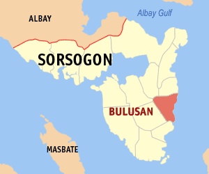
Bulusan, officially the Municipality of Bulusan, ; Tagalog: Bayan ng Bulusan), is a 4th class municipality in the province of Sorsogon, Philippines. According to the 2015 census, it has a population of 22,884 people.

Castilla, Sorsogon Municipality in Bicol Region, Philippines

Castilla, officially the Municipality of Castilla, is a 3rd class municipality in the province of Sorsogon, Philippines. According to the 2015 census, it has a population of 57,827 people.

Donsol Municipality in Bicol Region, Philippines

Donsol, officially the Municipality of Donsol, is a 3rd class municipality in the province of Sorsogon, Philippines. According to the 2015 census, it has a population of 49,711 people.

Gubat, Sorsogon Municipality in Bicol Region, Philippines

Gubat, officially the Municipality of Gubat, is a 2nd class municipality in the province of Sorsogon, Philippines. According to the 2015 census, it has a population of 59,534 people.

Juban, Sorsogon Municipality in Bicol Region, Philippines

Juban, officially the Municipality of Juban, is a 4th class municipality in the province of Sorsogon, Philippines. According to the 2015 census, it has a population of 32,320 people.

Pilar, Sorsogon Municipality in Bicol Region, Philippines

Pilar, officially the Municipality of Pilar, is a 1st class municipality in the province of Sorsogon, Philippines. According to the 2015 census, it has a population of 74,564 people.Pilar's economy is mainly agricultural. Despite efforts on multiplicity, this town is still dependent on the monoculture of coconut.

Santa Magdalena, Sorsogon Municipality in Bicol Region, Philippines

Santa Magdalena, officially the Municipality of Santa Magdalena, is a 5th class municipality in the province of Sorsogon, Philippines. According to the 2015 census, it has a population of 16,848 people.

Monreal, Masbate Municipality in Bicol Region, Philippines

Monreal, officially the Municipality of Monreal, is a 4th class municipality in the province of Masbate, Philippines. According to the 2015 census, it has a population of 26,614 people.

San Jacinto, Masbate Municipality in Bicol Region, Philippines

San Jacinto, officially the Municipality of San Jacinto, is a 4th class municipality in the province of Masbate, Philippines. According to the 2015 census, it has a population of 30,372 people.

Calabanga Municipality in Bicol Region, Philippines

Calabanga, officially the Municipality of Calabanga, is a 1st class municipality in the province of Camarines Sur, Philippines. According to the 2015 census, it has a population of 83,033 people.

The legislative districts of Sorsogon are the representations of the province of Sorsogon in the various national legislatures of the Philippines. The province is currently represented in the lower house of the Congress of the Philippines through its first and second congressional districts.

References

  1. "Municipality". Quezon City, Philippines: Department of the Interior and Local Government. Retrieved 31 May 2013.
  2. "Province: Sorsogon". PSGC Interactive. Quezon City, Philippines: Philippine Statistics Authority . Retrieved 12 November 2016.
  3. 1 2 3 Census of Population (2015). "Region V (Bicol Region)". Total Population by Province, City, Municipality and Barangay. PSA . Retrieved 20 June 2016.
  4. "PSA releases the 2015 Municipal and City Level Poverty Estimates". Quezon City, Philippines. Retrieved 1 January 2020.
  5. "Irosin, Sorsogon : Average Temperatures and Rainfall". Meteoblue. Retrieved 29 December 2018.
  6. Note: Brief historical account and poetic translation were drawn from the Irosin Town Fiesta '93 (September 20–29, 1993) Souvenir Magazine, "A toast to an alternative celebration!" - LG Ubalde
  7. Census of Population and Housing (2010). "Region V (Bicol Region)". Total Population by Province, City, Municipality and Barangay. NSO . Retrieved 29 June 2016.
  8. Censuses of Population (1903–2007). "Region V (Bicol Region)". Table 1. Population Enumerated in Various Censuses by Province/Highly Urbanized City: 1903 to 2007. NSO.
  9. "Province of Sorsogon". Municipality Population Data. Local Water Utilities Administration Research Division. Retrieved 17 December 2016.
  10. Irosin Tourism