The Irtysh–Karamay–Ürümqi Canal (Chinese:引额济克(乌)工程; pinyin:Yǐn-É-jì-Kè (Wū) gōngchéng; lit.'Irtysh River Diversion to Karamay (Ürümqi) Project'), also known as the Project 635 (Chinese:635工程; pinyin:635 gōngchéng; lit.'Project 635')[1] Canal, is a system of water-transfer canals and reservoirs in the northern part of China's Xinjiang Uighur Autonomous Region. It transfers water from the Irtysh River (which flows toward the Arctic Ocean) into several dry endorheic basins of north-central Xinjiang, where it is used for irrigation and general use of the population and industries.
The canal is often referred in Chinese publications simply the "Project for Supplying Water From the Irtysh" ("引额供水"工程).[2]
According to Chinese planners, the water carried by the canal will eventually irrigate 140,000 hectares of land.[1] An important user of the canal's water is the petroleum industry around Karamay.[1]
History
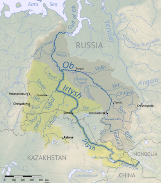
The ideas for redirecting some of the waters of the Irtysh for irrigation use in the (Soviet) Central Asia was actively discussed in the USSR in the mid-20th century. However, the bulk of the Soviet Northern river reversal project was never implemented; only a fairly minor Irtysh–Karaganda Canal was constructed in central Kazakhstan. The upper course of the Irtysh, is, however, in China, and it was the Chinese authorities who, in the 1990s, embarked on a large-scale project for the use of some of the waters of that river in the Chinese part of Central Asia, i.e. Xinjiang. The project was approved by all the relevant authorities by 2000,[3] and construction work started soon thereafter. The water reached Karamay by 2008.[citation needed]
From the three trunk canals' junction point, the West Trunk Canal running in the general southwestern direction, skirting the northwestern edge of the Dzungarian Basin along the foothills of the mountains that form the basin's border.
There are several tunnels along the canal's route, including the Dingshan Tunnel (Chinese:顶山隧洞), which is 7,415 m long.[9]
More water for the canal
The Project 635 reservoir is required not only to supply the Irtysh–Karamay–Ürümqi Canal with water, but also to maintain a sufficient amount of water flow in the Irtysh below the dam, for the local agricultural use and ecosystem maintenance. To improve the water balance at the reservoir, the local authorities are envisioning the so-called Project for Bringing Western Water to the East (西水东引工程). The project would involve the construction of a canal whereby water could be transferred from the Burqin Shankou Reservoir on the Burqin River to the Project 635 reservoir on the Irtysh.[3][10] Even though the Burqin is a tributary of the Irtysh, its natural confluence point with the Irtysh is in Burqin Town (the county seat of Burqin County), which is over 100 km downstream from the Project 635 Dam, and in the absence of the "Bringing Western Water to the East" canal its waters would not be available at the Project 635 location.[citation needed]
↑ 额河建管局工程建设和科技发展情况 (Overview of the construction and scientific development projects of the Irtysh Development and Construction Authority), 2010-08-05, by Irtysh Basin Development and Construction Authority (额尔齐斯河流域开发建设管理局)
Related Research Articles
The Irtysh is a river in Russia, China, and Kazakhstan. It is the chief tributary of the Ob and is also the longest tributary river in the world.
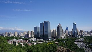
Ürümqi is the capital of the Xinjiang Uyghur Autonomous Region in Northwestern China. With a census population of 4 million in 2020, Ürümqi is the second-largest city in China's northwestern interior after Xi'an, as well as the largest in Central Asia in terms of population. Ürümqi has seen significant economic development since the 1990s and currently serves as a regional transport node and a cultural, political and commercial center.
Karamay is a prefecture-level city in the north of the Xinjiang Uyghur Autonomous Region, People's Republic of China. It is surrounded on all sides by Tacheng Prefecture. The name of the city comes from the Uyghur language and means "black oil", referring to the oil fields near the city.
Fukang is a county-level city in Xinjiang Uygur Autonomous Region, China. Its area is 11,726 km2 (4,527 sq mi) and its population in 2007 was reported as approximately 1.5 million. Fukang is located in Northern Xinjiang in Changji Hui Autonomous Prefecture, north of Ürümqi.
Water tunnels are tunnels used to transport water to areas with large populations or agriculture. They are frequently part of aqueducts. Some aqueducts, such as the Delaware Aqueduct are single long tunnels. In other cases, such as the San Jacinto Tunnel on the Colorado River Aqueduct, water tunnels form parts of far longer aqueducts. In cases where the outflow of a water tunnel is into an existing stream or river flowing to the point of water use, the term aqueduct is less likely to be used, as with the Harold D. Roberts Tunnel from Dillon Reservoir to the North Fork South Platte River.
The South–North Water Transfer Project, also translated as the South-to-North Water Diversion Project, is a multi-decade infrastructure mega-project in China that aims to channel 44.8 cubic kilometers of fresh water each year from the Yangtze River in southern China to the more arid and industrialized north through three canal systems:
Burqin County is a county in Xinjiang, China and is under the administration of the Kazakh autonomous area of Altay Prefecture. It has an area of 10,362 km2 (4,001 sq mi) with a population of 70,000. The postcode is 836600.
Orku District is a district of Karamay City, Xinjiang, China. It contains an area of 2,229 km2 (861 sq mi). According to the 2002 census, it has a population of 10,000.
Midong District is one of 7 urban districts of the prefecture-level city of Ürümqi, the capital of Xinjiang Uygur Autonomous Region, Northwest China. Its land area is 3,408 km2 (1,316 sq mi); it has a population of 296,000.
The Northern river reversal or Siberian river reversal was an ambitious project to divert the flow of the Northern rivers in the Soviet Union, which "uselessly" drain into the Arctic Ocean, southwards towards the populated agricultural areas of Central Asia, which lack water.
The Gurbantünggüt Desert occupies a large part of the Dzungarian Basin in Northern Xinjiang, in the northwest of the People's Republic of China. It is also called by some sources Dzoosotoyn Elisen Desert, from the Mongolian language.
The Ulungur River / Urungu River or Urungu, in its upper reaches in Mongolia known as the Bulgan River, is a river of China and Mongolia. It rises in the Altai Mountains in western Mongolia, flows south into China's Xinjiang, where it turns north-west to empty into the Ulungur Lake. It is about 700 km long.
The Project 635 Dam is one of the three dams constructed on the Irtysh River in China's Xinjiang Uighur Autonomous Region. The embankment dam is located in Fuhai County, about 56 km east of Beitun. It creates a reservoir, which serves as the source of water for the Irtysh–Karamay–Ürümqi Canal.
The Fengcheng Reservoir is a reservoir on the Irtysh–Karamay Canal in China's Xinjiang Uighur Autonomous Region. It is about 15 km north of the main urban area of Urho District of Karamay City; administratively, the location is near the border of Urho District and Hoboksar Mongol Autonomous County.
The Baiyang River, also known under a Mongolian name transcribed in Chinese as Namuguolei, is a river in Xinjiang Uighur Autonomous Region of China. It flows through the region's Tacheng Prefecture and the Urho District of Karamay City. The river's total length is estimated at 170 kilometres (110 mi), and the average annual flow at 109 million cubic metres (88,000 acre⋅ft). The river's basin occupies 16,400 square kilometres (6,300 sq mi),
The Manas Lake is a salt lake in the Xinjiang Uighur Autonomous Region. It is located in the western part of the Dzungarian Basin, within the Gurbantünggüt Desert. Administratively, the lake is in Hoboksar Mongol Autonomous County; the closest urban settlement is Urho District of Karamay City, some 40 kilometres (25 mi) to the northwest of the lake.
The Ailik or Aylik Lake is a lake in Xinjiang Uighur Autonomous Region, China. It is located in the northwestern part of the Dzungarian Basin, on the edge of the Gurbantünggüt Desert. Administratively, the lake is situated within the Urho District of Karamay City, some 20 km south-east of the district's main urban area.
The Burqin Shankou Dam is an arch dam in Burqin County of Xinjiang Uighur Autonomous Region of China.
This page is based on this Wikipedia article Text is available under the CC BY-SA 4.0 license; additional terms may apply. Images, videos and audio are available under their respective licenses.