
San Luis Obispo County, officially the County of San Luis Obispo, is a county on the Central Coast of California. As of the 2020 census, the population was 282,424. The county seat is San Luis Obispo.

San Luis Obispo is a city and county seat of San Luis Obispo County, in the U.S. state of California. Located on the Central Coast of California, San Luis Obispo is roughly halfway between the San Francisco Bay Area in the north and Greater Los Angeles in the south. The population was 47,063 at the 2020 census.

Hollister Peak is a 1,404-foot (428 m) volcanic plug located near Morro Bay, California. It is one of the Nine Sisters, and receives its name from the family that lived at its base in 1884. It was of religious importance to the Chumash. Hollister Peak is on private property and has no public access.

Cerro Cabrillo, also known locally as Cabrillo Peak, is a rocky mountain in eastern Morro Bay State Park, San Luis Obispo County, central California.

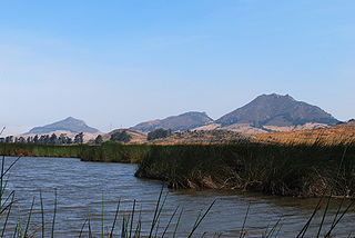
The Nine Sisters or the Morros are a chain of twenty-three, although typically only nine are included, volcanic mountains and hills in western San Luis Obispo County, Southern California. They run between Morro Bay and San Luis Obispo.
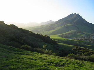
Bishop Peak is a 1,546-foot (471 m) volcanic plug in San Luis Obispo, California. It is the tallest of the Morros or "Nine Sisters", a chain of similar peaks stretching to Morro Bay. Often said to take its name from its resemblance to a bishop's miter, it is named in homage to the town's name. "Obispo" is the Spanish word for Bishop.

Morro Rock is a volcanic plug in Morro Bay, California, on the Pacific Coast at the entrance to Morro Bay harbor. A causeway connects it with the shore, making it a tied island. The rock is protected as the Morro Rock State Preserve.

San Luis Obispo County Regional Airport, McChesney Field is a civil airport near San Luis Obispo, California, United States. Three passenger airlines serve the airport with nonstop flights to eight cities: Dallas-Fort Worth, Denver, Los Angeles, Phoenix, Portland, San Diego, San Francisco and Seattle. The airport was established in 1939 and used by the U.S. military between 1939 and 1945.

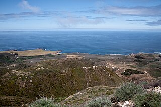
Montaña de Oro is a state park in Central Coastal California, six miles southwest of Morro Bay and two miles south of Los Osos.
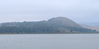
Black Hill is a mountain situated in Morro Bay, California, part of Morro Bay State Park. It one of a series of volcanic plugs called the Nine Sisters.
Cerro Romualdo is a 1,300-foot (396 m) mountain in San Luis Obispo County, California. The mountain is the fifth in a series of volcanic plugs called the Nine Sisters. Until 1964 the mountain was officially known as Romualdo Peak.
Chumash Peak is a 1,257 ft (383 m) mountain in San Luis Obispo County, California. It is just northwest of San Luis Obispo, on the south side of California State Route 1.

The Edna Valley AVA is an American Viticultural Area located in San Luis Obispo County, California encompassing the rural town of Edna, which is south of the county seat San Luis Obispo and north of the small coastal town Arroyo Grande. It is a sub-region of the larger Central Coast AVA. The valley is roughly bounded by Lake Lopez to the south and Islay Hill to the north. The valley runs east to west, bounded to the west by the Santa Lucia Mountains. It is surrounded by volcanic mountains and characterized by black humus and clay-rich soils. With moderate sunshine, cool maritime fog, and rich oceanic and volcanic soils, the Edna Valley appellation has California's longest growing season. The valley is kept cool by breezes from the Pacific Ocean and morning fog. The extended growing season gives complex flavors to the grapes.

The Los Osos Valley is a valley within San Luis Obispo County, in the Central Coast of California region.
Rancho Suey was a 48,834-acre (197.62 km2) Mexican land grant in present-day southern San Luis Obispo County and northern Santa Barbara County, California given in 1837 by Governor Juan B. Alvarado to María Ramona Carrillo de Pacheco. The grant was east of present-day Santa Maria and extended along the San Luis Obispo-Santa Barbara County line, and between the Santa Maria River and the Cuyama River.
Rancho El Chorro was a 3,167-acre (12.82 km2) Mexican land grant in present day San Luis Obispo County, California given in 1845 by Governor Pío Pico to business partners James (Diego) Scott and John (Juan) Wilson. The grant between Morro Bay and San Luis Obispo extended along the north bank of Chorro Creek.
Rancho San Luisito was a 4,389-acre (17.76 km2) Mexican land grant in present day San Luis Obispo County, California given in 1841 by Governor Juan B. Alvarado to José de Guadalupe Cantúa. The grant between Morro Bay and San Luis Obispo, extended along San Luisito Creek and Chorro Creek and encompassed Hollister Peak.
Rancho Cañada de los Osos y Pecho y Islay was a 32,431-acre (131.24 km2) Mexican land grant in Los Osos Valley and the southern Estero Bay headlands, in present-day San Luis Obispo County, California.
Rancho Pecho y Islay was an 8,856.8-acre (35.842 km2) Mexican land grant in the Irish Hills, Montaña de Oro State Park and Diablo Canyon Power Plant in present-day San Luis Obispo County, California.
Rancho Cañada de los Osos was a 23,574.2-acre (95.401 km2) Mexican land grant in Los Osos Valley in present-day San Luis Obispo County, California.
