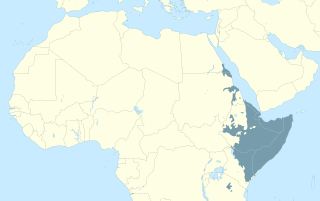
The Cushitic languages are a branch of the Afroasiatic language family. They are spoken primarily in the Horn of Africa, with minorities speaking Cushitic languages to the north in Egypt and Sudan, and to the south in Kenya and Tanzania. As of 2012, the Cushitic languages with over one million speakers were Oromo, Somali, Beja, Afar, Hadiyya, Kambaata, and Sidama.
The Nilotic peoples are people indigenous to the Nile Valley who speak Nilotic languages. They inhabit South Sudan, Sudan, Ethiopia, Uganda, Kenya, the northern border area of Democratic Republic of the Congo, Rwanda, Burundi and Tanzania. Among these are the Burun-speaking peoples, Teso people also known as Iteso or people of Teso, Karo peoples, Luo peoples, Ateker peoples, Kalenjin peoples, Karamojong people also known as the Karamojong or Karimojong, Datooga, Dinka, Nuer, Atwot, Lotuko, and the Maa-speaking peoples.

Nubians are a Nilo-Saharan speaking ethnic group indigenous to the region which is now northern Sudan and southern Egypt. They originate from the early inhabitants of the central Nile valley, believed to be one of the earliest cradles of civilization. In the southern valley of Egypt, Nubians differ culturally and ethnically from Egyptians, although they intermarried with members of other ethnic groups, especially Arabs. They speak Nubian languages as a mother tongue, part of the Northern Eastern Sudanic languages, and Arabic as a second language.

The Beja people are a Cushitic ethnic group native to the Eastern Desert, inhabiting a coastal area from southeastern Egypt through eastern Sudan and into northwestern Eritrea. They are descended from peoples who have inhabited the area since 4000 BC or earlier, although they were Arabized by Arabs who settled in the region. They are nomadic and live primarily in the Eastern Desert. The Beja number around 1,900,000 to 2,759,000.
Beja is an Afroasiatic language of the Cushitic branch spoken on the western coast of the Red Sea by the Beja people. Its speakers inhabit parts of Egypt, Sudan and Eritrea. In 2022 there were 2,550,000 Beja speakers in Sudan, and 121,000 Beja speakers in Eritrea according to Ethnologue. As of 2023 there are an estimated 88,000 Beja speakers in Egypt. The total number of speakers in all three countries is 2,759,000.
Medjay was a demonym used in various ways throughout ancient Egyptian history to refer initially to a nomadic group from Nubia and later as a generic term for desert-ranger police. They were sometimes confused with the Pan-Grave Culture.
Wadi Allaqi, also transliterated as Wadi Allaqui or Wadi Alalaqi, is a wadi in southern Egypt. It begins in Sudan below the Halaib Triangle, and its mouth is south of Aswan on the eastern shore of Lake Nasser.
Banu Kanz, also known as Awlad Kanz, was a semi-nomadic Muslim dynasty of Arab descent that ruled the border region between Upper Egypt and Nubia between the 10th and 15th centuries. They were descended from the sons of sheikhs of the Arab Banu Hanifa tribe who intermarried with the princesses of the Beja Hadariba tribe. They gained official control over the region of Aswan, Wadi Allaqi and the frontier zone in the early 11th century when their chief, Abu al-Makarim Hibatallah, captured a major rebel on behalf of the Fatimid authorities. Abu al-Makarim was accorded the title Kanz al-Dawla by Caliph al-Hakim and his successors inherited the title. The Banu Kanz entered into conflict with the Ayyubids in 1174, during which they were defeated and forced to migrate southward into northern Nubia, where they helped accelerate the expansion of Islam in the mostly Christian region. They eventually assumed control of the Nubian Kingdom of Makuria in the early 14th century, but by the early the 15th century, they were supplanted by the Hawwara tribesmen dispatched by the Mamluks to combat the Banu Kanz. Their modern-day descendants are a Sudanese tribe known as the "Kunuz", who live in the far north of the country.

Lower Nubia is the northernmost part of Nubia, roughly contiguous with the modern Lake Nasser, which submerged the historical region in the 1960s with the construction of the Aswan High Dam. Many ancient Lower Nubian monuments, and all its modern population, were relocated as part of the International Campaign to Save the Monuments of Nubia; Qasr Ibrim is the only major archaeological site which was neither relocated nor submerged. The intensive archaeological work conducted prior to the flooding means that the history of the area is much better known than that of Upper Nubia. According to David Wengrow, the A-Group Nubian polity of the late 4th millenninum BCE is poorly understood since most of the archaeological remains are submerged underneath Lake Nasser.

The Kingdom of Kerma or the Kerma culture was an early civilization centered in Kerma, Sudan. It flourished from around 2500 BC to 1500 BC in ancient Nubia. The Kerma culture was based in the southern part of Nubia, or "Upper Nubia", and later extended its reach northward into Lower Nubia and the border of Egypt. The polity seems to have been one of a number of Nile Valley states during the Middle Kingdom of Egypt. In the Kingdom of Kerma's latest phase, lasting from about 1700 to 1500 BC, it absorbed the Sudanese kingdom of Sai and became a sizable, populous empire rivaling Egypt. Around 1500 BC, it was absorbed into the New Kingdom of Egypt, but rebellions continued for centuries. By the eleventh century BC, the more-Egyptianized Kingdom of Kush emerged, possibly from Kerma, and regained the region's independence from Egypt.
The C-Group culture is an archaeological culture found in Lower Nubia, which dates from c. 2400 BCE to c. 1550 BCE. It was named by George A. Reisner. With no central site and no written evidence about what these people called themselves, Reisner assigned the culture a letter. The C-Group arose after Reisner's A-Group and B-Group cultures, and around the time the Old Kingdom was ending in Ancient Egypt.

The Arabian-Nubian Shield (ANS) is an exposure of Precambrian crystalline rocks on the flanks of the Red Sea. The crystalline rocks are mostly Neoproterozoic in age. Geographically – and from north to south – the ANS includes parts of Israel, Jordan, Egypt, Saudi Arabia, Sudan, Eritrea, Ethiopia, Yemen, and Somalia. The ANS in the north is exposed as part of the Sahara Desert and Arabian Desert, and in the south in the Ethiopian Highlands, Asir province of Arabia and Yemen Highlands.
The Badarian culture provides the earliest direct evidence of agriculture in Upper Egypt during the Predynastic Era. It flourished between 4400 and 4000 BC, and might have already emerged by 5000 BC.

The Eastern Desert is the part of the Sahara Desert that is located east of the Nile River. It spans 223,000 square kilometres (86,000 sq mi) of northeastern Africa and is bordered by the Gulf of Suez and the Red Sea to the east, and the Nile River to the west. It extends through Egypt, Eritrea, Ethiopia, and the Sudan. The Eastern Desert consists of a mountain range which runs parallel to the coast, wide sedimentary plateaus extending from either side of the mountains and the Red Sea coast. The rainfall, climate, vegetation and animal life sustained in the desert varies between these different regions. The Eastern Desert has been a mining site for building materials, as well as precious and semi-precious metals, throughout history. It has historically contained many trade routes leading to and from the Red Sea, including the Suez Canal.

The Bishari are a Cushitic ethnic group who live in parts of Northeast Africa. They are one of the major divisions of the Beja people. Apart from local dialects of Arabic, the Bishari speak the Beja language, which belongs to the Afroasiatic family of the Cushitic branch.

The Blemmyes were an Eastern Desert people who appeared in written sources from the 7th century BC until the 8th century AD. By the late 4th century, they had occupied Lower Nubia and established a kingdom. From inscriptions in the temple of Isis at Philae, a considerable amount is known about the structure of the Blemmyan state.

The Gulf of Suez Rift is a continental rift zone that was active between the Late Oligocene and the end of the Miocene. It represented a continuation of the Red Sea Rift until break-up occurred in the middle Miocene, with most of the displacement on the newly developed Red Sea spreading centre being accommodated by the Dead Sea Transform. During its brief post-rift history, the deepest part of the remnant rift topography has been filled by the sea, creating the Gulf of Suez.

Nubia is a region along the Nile river encompassing the confluence of the Blue and White Niles, and the area between the first cataract of the Nile or more strictly, Al Dabbah. It was the seat of one of the earliest civilizations of ancient Africa, the Kerma culture, which lasted from around 2500 BC until its conquest by the New Kingdom of Egypt under Pharaoh Thutmose I around 1500 BC, whose heirs ruled most of Nubia for the next 400 years. Nubia was home to several empires, most prominently the Kingdom of Kush, which conquered Egypt in the eighth century BC during the reign of Piye and ruled the country as its 25th Dynasty.
Wadi el-Hudi is a mining region that includes a large wadi and a mountain named Gebel el-Hudi in the Egyptian Eastern Desert, Southeast of Aswan. The name hudi is thought to come from the Arabic word for guide. Wadi el-Hudi is geologically rich and has been the basis of considerable mining and study since Ancient times. While it was initially known for the ancient amethyst quarries, this area is important the study of Egyptian archaeology and history because of its high number of rock inscriptions, stele, settlements, and mines, mainly dating to the Middle Kingdom. This area is fairly large, about 100 square kilometers.

Cushitic-speaking peoples are the ethnolinguistic groups who speak Cushitic languages natively. Today, the Cushitic languages are spoken as a mother tongue primarily in the Horn of Africa, with minorities speaking Cushitic languages to the north and south in Egypt, Sudan, Kenya, and Tanzania.

