
Rapid KL is a public transportation system owned by Prasarana Malaysia and operated by its subsidiaries Rapid Rail and Rapid Bus. The acronym stands for Rangkaian Pengangkutan Integrasi Deras Kuala Lumpur, which translates to Kuala Lumpur Rapid Integrated Transport Network in the Malay language. Rapid KL, with its 204.1 km (126.8 mi) of metro railway and 5.6 km (3.5 mi) of BRT carriageway, is part of the Klang Valley Integrated Transit System, operating throughout Kuala Lumpur and Selangor's satellite cities in the Klang Valley area.

Ampang, or Ampang Hilir, is a ward and city district, in the eastern part of Kuala Lumpur (KL) in the Titiwangsa constituency. Its area in Kuala Lumpur can be identified as being along the Ampang Road and Ampang Hilir.
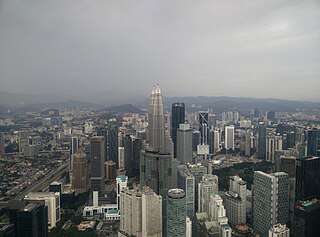
Kuala Lumpur City Centre (KLCC) is a multipurpose development area in Kuala Lumpur, Malaysia. KLCC refers to the area within and surrounding the KLCC Park but the term has also been widely used by buildings nearby to the vicinity.

Wangsa Maju is a township and a constituency in Kuala Lumpur, Malaysia. This area is surrounded by Setapak, Taman Melati and Gombak district in Selangor. Wangsa Maju is one of the major suburbs in Kuala Lumpur.

Setapak is a town and mukim straddling both norteastern Kuala Lumpur and Gombak District of Selangor, Malaysia.

Kampung Datuk Keramat or more commonly referred to as Keramat among the locals is a large zone in the Titiwangsa constituency, falling within the boundary of the Federal Territory of Kuala Lumpur, Malaysia. It is located northeast of downtown Kuala Lumpur and borders the district of Ampang in Selangor. The Klang River runs roughly from northeast to the west and acts as a natural divider of Keramat and Ampang.
Jalan Ampang or Ampang Road is a major road in the Klang Valley region, Selangor and the Federal Territory of Kuala Lumpur, Malaysia. Built in the 1880s, it is one of the oldest roads in the Klang Valley. It is a main road to Ampang Jaya and is easily accessible from Jalan Tun Razak or Jalan Ulu Klang from the Hulu Kelang or Setapak direction. It is also accessible from Cheras through Jalan Shamelin, from Jalan Tun Razak through Jalan Kampung Pandan via Taman Cempaka, from Kampung Pandan through Jalan Kampung Pandan Dalam via Taman Nirwana, from the Kuala Lumpur Middle Ring Road 2 via Pandan Indah and Taman Kencana and from Hulu Langat town through the mountain pass. Wangsa Maju, Setapak, central Kuala Lumpur, Ampang Park and Salak South surround Ampang. Jalan Ampang became the backbone of the road system linking Ampang to Kuala Lumpur before being surpassed by the Ampang–Kuala Lumpur Elevated Highway (AKLEH) in 2001.

Ampang Jaya, more commonly known as just Ampang, is a town, a mukim and a parliamentary constituency straddling parts of the Hulu Langat District and Gombak District, in eastern Selangor, Malaysia. It is located just outside the eastern border of Kuala Lumpur Federal Territory.
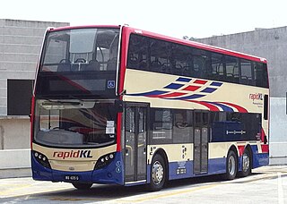
Rapid Bus Sdn Bhd is the largest bus operator in Malaysia operating mainly in urban areas of Klang Valley, Penang & Kuantan. As of February 2023, Rapid KL service brands unit of Rapid Bus, has operates 113 normal routes and also 69 MRT Feeder Bus routes, along with 8 Nadiputra routes in Putrajaya.

Dang Wangi LRT station is an underground metro station, in Kuala Lumpur, Malaysia, part of the Kelana Jaya Line. The station was opened on June 1, 1999, as part of the line's second and latest extension, which includes the addition of 12 stations, and an underground line that the Dang Wangi station is connected to. The Dang Wangi station is one of only five underground stations in the Kelana Jaya Line.

Titiwangsa station is a rapid transit interchange station in Kuala Lumpur, Malaysia. The station is served by the LRT Ampang and Sri Petaling Lines, the KL Monorail Line and the MRT Putrajaya Line. The station allows seamless physical and fare integration between the four train lines.
Transport in Greater Kuala Lumpur includes a road network, a railway network, airports, and other modes of public transport. Greater Kuala Lumpur is conterminous with the Klang Valley, an urban conglomeration consisting of the city of Kuala Lumpur, as well as surrounding towns and cities in the state of Selangor. The Klang Valley has the country's largest airport, the Kuala Lumpur International Airport (KLIA), as well as the country's largest intermodal transport hub and railway station, Kuala Lumpur Sentral.

Chan Sow Lin station is an integrated metro station in Pudu, Kuala Lumpur, Malaysia. The station serves as an interchange station between the LRT Sri Petaling Line, LRT Ampang Line and the MRT Putrajaya Line. The station consists of an at-grade station for the Ampang and Sri Petaling lines, and an underground station for the Putrajaya line. Both stations are connected by an elevated pedestrian walkway, allowing paid-to-paid integration.

Damai LRT station is an elevated rapid transit station in Kuala Lumpur, Malaysia, forming part of the Kelana Jaya line. The station was opened on 1 June 1999, as part of the line's second segment from Pasar Seni to Gombak. It is one of the 13 stations between Masjid Jamek and Gombak.

Setiawangsa LRT station is an elevated rapid transit station in Ampang, Malaysia, served by the LRT Kelana Jaya Line. The station was opened on June 1, 1999, as part of the line's second segment encompassing 12 stations between Masjid Jamek and Gombak and an underground line.
Pandan Indah LRT station is a Malaysian low-rise light rapid transit (LRT) station situated near and named after Pandan Indah, in Ampang Jaya, Selangor. The station of the LRT Ampang Line, was opened on December 16, 1996, as part of the first phase of the STAR system's operations, alongside 13 adjoining stations along the Sultan Ismail-Ampang route.
Cahaya LRT station is a Malaysian low-rise rapid transit station situated near and named after the nearby Taman Cahaya (Malay; English: Cahaya Estate, in Ampang Jaya, Selangor. The station is part of the Ampang Line, and was opened on December 16, 1996, as part of the first phase of the STAR system's opening, alongside 13 adjoining stations along the Sultan Ismail-Ampang route.

The Maluri station is an integrated light rapid transit (LRT) and mass rapid transit (MRT) located on the eastern fringe of Kuala Lumpur near and named after Taman Maluri, a residential housing estate. The station is located along Federal Route 1 Jalan Cheras opposite the AEON Taman Maluri shopping centre and Sunway Velocity Mall. The Kerayong River also runs beside the station.

Ampang Park LRT station is a light rapid transit (LRT) station in Kuala Lumpur that is served by RapidKL's LRT Kelana Jaya Line. The LRT station is the last underground station on the Kelana Jaya Line along Jalan Ampang, near the Jalan Tun Razak intersection, before the line heads above ground again at Damai LRT station.

Setiawangsa–Pantai Expressway (SPE) is a 29.8-kilometre (18.5 mi) expressway in Klang Valley, Malaysia that connects Taman Melati and Klang Gates from FT 28 Kuala Lumpur Middle Ring Road 2 to Sprint Expressway - Kerinchi Link and FT 2 Federal Highway at Kerinchi near Pantai and University of Malaya. The alignment of this highway will traverse north to south of Kuala Lumpur and will serve areas such as Tunku Abdul Rahman University of Management and Technology, Wangsa Maju, Setiawangsa, Ampang, the Tun Razak Exchange and Bandar Malaysia development corridor as well as providing a connection to Kuala Lumpur-Karak Experessay to the east coast. It was built and maintained by Ekovest Berhad. It is formerly known as DUKE Phase 3.


