Wangsa Maju

Last updated

Wangsa Maju
Township
Wangsa Maju cityscape (211031).jpg
Skyline of Wangsa Maju from the LRT Station
Nickname: 
Hawthornden (old name)
Malaysia location map.svg
Red pog.svg
Wangsa Maju
Location within Malaysia
Kuala Lumpur locator map.svg
Red pog.svg
Wangsa Maju
Wangsa Maju (Kuala Lumpur)
Coordinates: 3°12′2″N101°44′23″E / 3.20056°N 101.73972°E / 3.20056; 101.73972
Country Malaysia
State Federal Territory of Kuala Lumpur
Constituency Wangsa Maju
Government
   Local Authority Dewan Bandaraya Kuala Lumpur
   Mayor Tan Sri Hj. Mhd. Amin Nordin bin Abd. Aziz
Time zone UTC+8 (MST)
Postcode
53000-53300
Dialling code +603-402, +603-403, , +603-410, +603-413, +603-414, +603-416
Police Wangsa Maju

Wangsa Maju is a township and a constituency in Kuala Lumpur, Malaysia. This area is surrounded by Setapak, Taman Melati and Gombak district in Selangor. Wangsa Maju is one of the major suburbs in Kuala Lumpur.

Contents

History

Kelana Jaya Line railway track at Wangsa Maju, 2023 Wangsa Maju, Kuala Lumpur 20231216 105621.jpg
Kelana Jaya Line railway track at Wangsa Maju, 2023

Wangsa Maju is a township in Kuala Lumpur, formed in 1984 during the city's 10th anniversary. [1] The area was previously occupied by Setapak rubber estates named as “Hawthornden” from the 1900s until the 1980s. The township is the second to be developed by the Kuala Lumpur City Hall (DBKL), with the first being Bandar Baru Tun Razak initiated in 1975. Subsequently, other new townships were developed in Sentul and Bukit Jalil. The new township project in Wangsa Maju is a joint venture between DBKL and a local company named Paremba Berhad. [2] [3]

Most residents of Wangsa Maju are from the low to middle-income group, and many flat units in the area were built and rented out at a lower monthly rental rate than the private sector's housing in Kuala Lumpur and Petaling Jaya. This provides opportunities for as many families as possible in the country to own their homes. Through this joint venture project, most of the houses to be built will be sold directly to the public. The council may keep a small number of these houses for renting to low-income groups who are forced to relocate due to government development projects. [2]

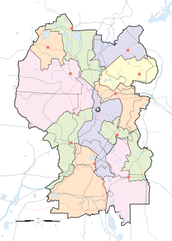
Wangsa Maju's commercial centre is known as the Kuala Lumpur Suburban Centre (KLSC). Initially, "Bandar Baru Titiwangsa Maju" was proposed as the name for the township. Wangsa Maju now only contains Sections 1, 2, 4, 5, 6, and 10, with no Sections 3,7,8 or 9 in between. Early charts indicated different sections of Wangsa Maju as "R", most likely referring to regions or residential areas. [4]

Following the opening of Tunku Abdul Rahman University of Management and Technology (TAR UMT) & Universiti Tunku Abdul Rahman (UTAR) campus, Wangsa Maju has become a major residential area for the students of TAR UMT & UTandR.

In May 2021, DBKL announced plans to transform Wangsa Maju's Section 1 into Kuala Lumpur's first zero-carbon township, focusing on green technologies. The project's goal is to provide the neighbourhood, which is mostly made up of low-cost flats, shophouses, and makeshift retail stores, with eco-conscious neighbourhoods that emphasise pedestrian walkways, jogging tracks and bicycle paths, as well as the replacement of ageing railings along residential areas. DBKL also wants residents to experience the benefits of living in an eco-friendly township so that they can better comprehend the larger objectives towards green solutions and combat climate change outlined in the KL Low-Carbon Society Blueprint 2030. DBKL also intends to transform vacant lots into landscaped gardens or urban farms. [4]

Facilities

Wangsa Link, one of the commercial areas in Wangsa Maju. Wangsa Maju Kuala Lumpur.jpg
Wangsa Link, one of the commercial areas in Wangsa Maju.

Shopping

Education

Others

Transport

Public transport

Wangsa Maju LRT Wangsa Maju LRT Station signboard (211031).jpg
Wangsa Maju LRT

Wangsa Maju is home to two Rapid KL LRT stations,  KJ3  Wangsa Maju LRT Station and  KJ4  Sri Rampai LRT Station. Kumpool, a ride-sharing DRT vanpool service to Wangsa Maju LRT Station also available here. [6]

Road networks

Wangsa Maju is well served by federal routes and expressways. Jalan Genting Klang Federal Route 2 links downtown Kuala Lumpur with Wangsa Maju and Setapak areas. [1] Motorists from Ampang and Pandan Indah will instead opt for the MRR2 Federal Route 28. [1] The Duta–Ulu Klang Expressway cuts through the southern part of Wangsa Maju. [1] The old road to Gombak and Bentong (Federal Route 68) also begins nearby.

Politics

Parliamentary boundaries can be confusing at times, particularly when it comes to the Wangsa Maju township. The Wangsa Maju Parliementary seat (P116) includes not only Sections 1, 2, and 4, but also Gombak, Danau Kota, and Taman Melati towards the Karak Highway. Before 2004, the Wangsa Maju constituency was part of the Setiawangsa constituency (P115). Nonetheless, some parts of Wangsa Maju are still administered by Setiawangsa, which causes some confusion among residents who live in Wangsa Maju yet vote for Setiawangsa. Also, the DBKL branch office at Wangsa Maju is called Setiawangsa, although another DBKL branch office called Wangsa Maju can be found on Jalan Gombak, possibly due to parliamentary boundaries. The area was first represented by Datuk Yew Teong Loke (MCA) in 2004. [7] In 2008 he lost to Wee Choo Keong (PKR) by merely 151 votes, subsequently this seat was win by the PKR for two terms [8]

The incumbent MP is Zahir Hassan of Pakatan Harapan-PKR, who won the 15th general election with a majority of 20,696 votes under the Pakatan Harapan flag. [9] The Setiawangsa constituency includes a portion of Wangsa Maju located south of Jalan Genting Klang, and the incumbent MP is Nik Nazmi, also of the PH-PKR.

Related Research Articles

<span class="mw-page-title-main">Gombak River</span> River in Kuala Lumpur and Selangor, Malaysia

The Gombak River is a river which flows through Selangor and Kuala Lumpur in Malaysia. It is a tributary of the Klang River. The point where it meets the Klang River is the origin of Kuala Lumpur's name.

<span class="mw-page-title-main">Puchong</span> Town in Selangor, Malaysia

Puchong is a major town and a parliamentary constituency in Petaling District, Selangor, Malaysia.

<span class="mw-page-title-main">Setapak</span>

Setapak is a mukim in Gombak District, Kuala Lumpur, Malaysia. Formerly a tin-mining and rubber estate area, in Malay tapak means 'step' so Setapak means 'one step', probably referring to the close proximity of the suburb to Kuala Lumpur. Another explanation of the origin of its name traces to its historical roots.

<span class="mw-page-title-main">Kampung Datuk Keramat</span>

Kampung Datuk Keramat or more commonly referred to as Keramat among the locals is a large zone in the Titiwangsa constituency, falling within the boundary of the Federal Territory of Kuala Lumpur, Malaysia. It is located northeast of downtown Kuala Lumpur and borders the district of Ampang in Selangor. The Klang River runs roughly from northeast to the west and acts as a natural divider of Keramat and Ampang.

Jalan Ampang or Ampang Road is a major road in the Klang Valley region, Selangor and the Federal Territory of Kuala Lumpur, Malaysia. Built in the 1880s, it is one of the oldest roads in the Klang Valley. It is a main road to Ampang Jaya and is easily accessible from Jalan Tun Razak or Jalan Ulu Klang from the Hulu Kelang or Setapak direction. It is also accessible from Cheras through Jalan Shamelin, from Jalan Tun Razak through Jalan Kampung Pandan via Taman Cempaka, from Kampung Pandan through Jalan Kampung Pandan Dalam via Taman Nirwana, from the Kuala Lumpur Middle Ring Road 2 via Pandan Indah and Taman Kencana and from Hulu Langat town through the mountain pass. Wangsa Maju, Setapak, central Kuala Lumpur, Ampang Park and Salak South surround Ampang. Jalan Ampang became the backbone of the road system linking Ampang to Kuala Lumpur before being surpassed by the Ampang–Kuala Lumpur Elevated Highway (AKLEH) in 2001.

<span class="mw-page-title-main">Ampang Jaya</span> Town in Selangor, Malaysia

Ampang Jaya, more commonly known as just Ampang, is a town, a mukim and a parliamentary constituency straddling parts of the Hulu Langat District and Gombak District, in eastern Selangor, Malaysia. It is located just outside the eastern border of Kuala Lumpur Federal Territory.

<span class="mw-page-title-main">Rapid Bus</span> Malaysian bus business

Rapid Bus Sdn Bhd is the largest bus operator in Malaysia operating mainly in urban areas of Klang Valley, Penang & Kuantan. As of February 2023, Rapid KL service brands unit of Rapid Bus, has operates 113 normal routes and also 69 MRT Feeder Bus routes, along with 8 Nadiputra routes in Putrajaya.

Transport in Greater Kuala Lumpur includes a road network, a railway network, airports, and other modes of public transport. Greater Kuala Lumpur is conterminous with the Klang Valley, an urban conglomeration consisting of the city of Kuala Lumpur, as well as surrounding towns and cities in the state of Selangor. The Klang Valley has the country's largest airport, the Kuala Lumpur International Airport (KLIA), as well as the country's largest intermodal transport hub and railway station, Kuala Lumpur Sentral.

<span class="mw-page-title-main">Wangsa Maju LRT station</span> Railway station in Kuala Lumpur, Malaysia

Wangsa Maju LRT station is an elevated rapid transit station in Wangsa Maju, Kuala Lumpur, Malaysia, forming part of the Kelana Jaya Line. The station opened on June 1, 1999, as part of the line's second segment encompassing 12 stations between Kelana Jaya station and Terminal PUTRA and an underground line.

<span class="mw-page-title-main">Geography of Kuala Lumpur</span> Geographical features of Kuala Lumpur

The geography of Kuala Lumpur, Malaysia is characterized by a huge valley — known as the Klang Valley — bordered by the Titiwangsa Mountains in the east, several minor ranges in the north and the south and the Malacca Straits in the west. The name Kuala Lumpur literally means muddy confluence; Kuala Lumpur is located at the confluence of the Klang and Gombak Rivers, facing the Malacca Straits.

<span class="mw-page-title-main">Genting Klang–Pahang Highway</span> Road in Malaysia

The Genting Klang–Pahang Highway or officially Jalan Genting Klang and Jalan Pahang, as it is locally known, is a major highway in Kuala Lumpur, Malaysia.

Taman Melati is a Malay majority township in Wangsa Maju, Kuala Lumpur, Malaysia. It is located between Gombak, Klang Gates, Wangsa Maju city centre and Taman Melawati. The 5 Kelana Jaya Line's  KJ2  Taman Melati LRT station is situated in this area.

<span class="mw-page-title-main">Greater Kuala Lumpur</span> Metropolitan area in Malaysia

Greater Kuala Lumpur is the geographical term that determines the boundaries of metropolitan Kuala Lumpur in Malaysia. Though similar to the term "Klang Valley", there remains a variation between the two. It is similar to Greater London and Greater Toronto. The metropolitan area covers 5,194.72 square km of land.

<span class="mw-page-title-main">Setapak Central</span> Shopping mall in Kuala Lumpur, Malaysia

Setapak Central, previously known as KL Festival City, is a shopping mall located along Jalan Genting Klang in Kuala Lumpur, Malaysia. It is situated in Danau Kota, a township in Setapak.

<span class="mw-page-title-main">Go KL City Bus</span>

Go KL City Bus is a free bus service in the city centre of Kuala Lumpur, Malaysia. Previously managed by Land Public Transport Commission (SPAD), the services were taken over by Kuala Lumpur City Hall (DBKL) by 1 January 2019.

<span class="mw-page-title-main">Kuala Lumpur Library</span> Library in Kuala Lumpur, Malaysia

The Kuala Lumpur Library is the main library of Kuala Lumpur, Malaysia. It has 15 branches around Kuala Lumpur :

Gombak is a town and locality in the mukim of Setapak in the coterminous Gombak District, Selangor, Malaysia.

<span class="mw-page-title-main">Taman Putra Perdana</span> Place in Selangor, Malaysia

Taman Putra Perdana is a township in Dengkil sub-district, Sepang District, Selangor, Malaysia. Although the township's postcode is 47100 / 47120 / 47130, which gives it Puchong postal address, it is actually in the Sepang constituency of Selangor, administered by the Sepang Municipal Council (MPSepang). The township was developed by Kenshine Corporation in 1997.

<span class="mw-page-title-main">Setiawangsa–Pantai Expressway</span> Road in Malaysia

Setiawangsa–Pantai Expressway (SPE) is a 29.8-kilometre (18.5 mi) expressway in Klang Valley, Malaysia that connects Taman Melati and Klang Gates from FT 28 Kuala Lumpur Middle Ring Road 2 to Sprint Expressway - Kerinchi Link and FT 2 Federal Highway at Kerinchi near Pantai and University of Malaya. The alignment of this highway will traverse north to south of Kuala Lumpur and will serve areas such as Tunku Abdul Rahman University of Management and Technology, Wangsa Maju, Setiawangsa, Ampang, the Tun Razak Exchange and Bandar Malaysia development corridor as well as providing a connection to Kuala Lumpur-Karak Experessay to the east coast. It was built and maintained by Ekovest Berhad. It is formerly known as DUKE Phase 3.

<span class="mw-page-title-main">Bukit Dinding</span> A hill in Kuala Lumpur

Bukit Dinding is a forested hill with published height of 291m in Kuala Lumpur sitting in between Setiawangsa and Wangsa Maju. There are variation of heights in different records where according to Google Earth (2022), the height of Bukit Dinding is 302m, but according to Kuala Lumpur Slope Information System (KULSIS), it is 311m.

References

  1. 1 2 3 4 5 6 7 8 9 Kaur, Sharen (9 August 2018). "Making an oasis in Wangsa Maju". New Straits Times. Retrieved 1 April 2019.
  2. 1 2 "A choice place to live with many high-rise and low-cost flats projects". The Star. 7 April 2018. Retrieved 14 March 2024.
  3. "PERASMIAN BANDAR BARU DI LADANG HAWTHORNDEN". Koleksi Arkib Ucapan Ketua Eksekutif. Retrieved 14 March 2024.
  4. 1 2 Datuk Yong, Soo Heong (29 May 2021). "Turning Wangsa Maju green". New Straits Times. Archived from the original on 7 March 2023. Retrieved 14 March 2024.
  5. "Setapak * KL EAST Central". setapakcentral.com.my.
  6. Rozlan, Ikmal (2 February 2023). "Rapid KL To End Kumpool T250 Feeder Bus". Lowyat.NET. Retrieved 7 March 2023.
  7. "Pilihan Raya Umum Malaysia". pmo.gov.my.
  8. "Pilihan Raya Umum Malaysia". pmo.gov.my.
  9. "Pilihan Raya Umum Malaysia". pmo.gov.my.

3°11′58″N101°44′24″E / 3.199495°N 101.7400196°E / 3.199495; 101.7400196