
West Jakarta is one of the five administrative cities of the Special Capital Region of Jakarta, Indonesia. West Jakarta is not self-governed and does not have a city council, hence it is not classified as a proper municipality. It had a population of 2,281,945 at the 2010 Census and 2,434,511 at the 2020 Census; the official estimate as at mid 2022 was 2,589,589 according to the BPS webpage for Jakarta Barat; however, the figure for Jakarta Barat according to the BPS DKI Jakarta webpage was 2,448,975. The administrative center of West Jakarta is at Puri Kembangan.

Grogol Petamburan is a district of West Jakarta, Indonesia, roughly bounded by the West Flood Canal to the east, Angke Canal to the west and to the north, and Jakarta-Merak Tollway to the south. It has an area 1,130 ha. As of 2004, the use of the land was 58.0% for housing, 12.5% for offices, 3.8% in parkland, and 2.2% in farmland with the remainder in other uses or idle.

Palmerah is a subdistrict of West Jakarta, Indonesia. The Subdistrict is roughly bounded by Jakarta-Merak Tollway to the north, Batusari - Rawa Belong Road to the west, Palmerah Barat - Palmerah Utara Road to the south, and Aipda K. Sasuit Tubun Road - Western Flood Canal to the east.

Pondok Indah is an upscale residential area in Pondok Pinang, Kebayoran Lama, South Jakarta, Indonesia. Dubbed as the Beverly Hills of Indonesia, this is a much sought-after suburb by expatriates, conglomerates, celebrities, and government officials. This area was built by the Metropolitan Kentjana Group in the 70s into the most prestigious and complete residential complex and commercial area in Indonesia. Houses in this suburb can run upwards to millions of U.S. dollars.

Kebayoran Baru is a district of South Jakarta, Indonesia. The name of the district was derived from an area which was developed in the post-war period as a new suburb town of Jakarta, Kebayoran Baru. Kebayoran Baru was the last residential area to be developed by the Dutch colonial administration. The urban planning was laid in a concept of the Garden city movement, consisting of a well-planned residential area, a shopping center, and a business district, supported with civic facilities e.g. schools, places of worship, hospitals, and parks. Many important governmental institutions are located in Kebayoran Baru, such as the Indonesia Stock Exchange building, the ASEAN Secretariat building, the Criminal Investigation Agency of the National Police, and the City Hall of South Jakarta. Sudirman Central Business District is also located in Kebayoran Baru sub-district.
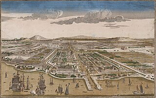
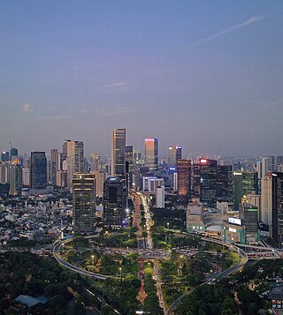
Jakarta is Indonesia's capital and largest city. Located on an estuary of the Ciliwung River, on the northwestern part of Java, the area has long sustained human settlement. Historical evidence from Jakarta dates back to the 4th century CE, when it was a Hindu settlement and port. The city has been sequentially claimed by the Indianized kingdom of Tarumanegara, the Hindu Kingdom of Sunda, the Muslim Sultanate of Banten, and by Dutch, Japanese and Indonesian administrations. The Dutch East Indies built up the area before it was taken during World War II by the Empire of Japan and finally became independent as part of Indonesia.
Central Park in Jakarta, Indonesia is a mixed-use complex including a shopping mall, an office tower, three apartment buildings, and a hotel covering an area of about 655,000 m2 (7,050,000 sq ft) located in the district of Grogol Petamburan, West Jakarta developed by the Agung Podomoro Group and part of Podomoro City development. Central Park is currently the 19th largest building in the world based on floor area.
Indonesian National Route 2 connects Jakarta and Cibadak, Sukabumi. It runs from north to south. It passes two provinces, namely Jakarta and West Java.

Koperasi Angkutan Jakarta or Kopaja was a cooperative established in 1971 to provide public transport services in Jakarta. There were reportedly over 1,400 minibuses in the Kopaja fleet in mid-2012, more than half of which were estimated to be over 20 years old.

Jalan M.H. Thamrin or Jalan Thamrin is a major thoroughfare in Jakarta, Indonesia. The road is located at the center of Jakarta, running from the north end of Jalan Jenderal Sudirman at West Flood Canal at the south end to the roundabout near Arjuna Wijaya Statue Jakarta at the north end. Developed in the 1950s, the road was a landmark of post-colonial Indonesia and continues to have a prominent importance in Jakarta.

Grogol Station (GGL) is a railway station in Jelambar, Grogol Petamburan, West Jakarta. It is the second station on the Duri-Tangerang branch line Brown Line service. The station is a strategic point for students as it is located within close proximity of Trisakti University and the University of Tarumanegara.

Jalan Jenderal Gatot Subroto(Gatot Subroto Avenue) is one of the major roads in Jakarta, Indonesia. The road starts from Dirgantara statue in South Jakarta, which crosses 10 administrative villages and ends at Slipi, Central Jakarta. The road is named after National Hero of Indonesia General Gatot Subroto. The road was constructed in 1960s. The road runs parallel with Jakarta Inner Ring Road. The location of the road is within the Golden Triangle CBD of Jakarta. Many important office buildings and skyscrapers are situated along the road.

Jalan Daan Mogot is one of the main avenues in Jakarta, Indonesia. The road is named after a military officer involved in the struggle for Indonesian independence Daan Mogot. This road stretches along 27.5 KM from Grogol, West Jakarta to Sukarasa, Tangerang, Tangerang. After entering Tangerang, this road continues to Jalan Merdeka and Jalan Gatot Subroto .This road is part of Indonesian National Route 1. This road crosses 14 urban villages, namely

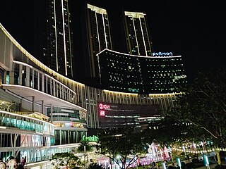
Mangga Dua is a shopping district at Pademangan subdistrict of North Jakarta, in Indonesia. The area is bordered by Jalan Gajah Mada in the west and Jalan Gunung Sahari in the east, while in the middle is Jalan Pangeran Jayakarta and Jalan Mangga Dua Raya. Mangga Dua is part of Jakarta's long history starting from Sunda Kelapa port and Glodok, which is biggest China town in Indonesia. The area is one of the 12 coastal tourism spots to attract foreign tourists by Dinas Pariwisata dan Kebudayaan. Mangga Dua and the contiguous Glodok are one of the biggest shopping areas in southeast Asia.
Semanggi Interchange or commonly known as Semanggi Bridge is a major road interchange in Jakarta, Indonesia which consists of a cloverleaf interchange —the first, and until the 1990s the only, of its kind in Indonesia—and a partial turbine interchange. Two main roads of the city Gatot Subroto Road and Sudirman Road intersect at this interchange. Initially completed in 1962 as part of several projects intended to be completed before the 1962 Asian Games, the interchange is a landmark and an important part of the Golden Triangle of Jakarta.
The following outline is provided as an overview of and topical guide to Jakarta:

The TransJakarta Corridor 9 is the TransJakarta bus rapid transit corridor that operates from the Pinang Ranti bus terminal in East Jakarta to the Pluit BRT station in North Jakarta. The streets traversed by corridor 9 are Jalan Pluit Putri/Putra, Jalan Jembatan Tiga, Jalan Prof Dr. Latumeten, Jalan Satria/Prof. Dr. Makaliwe, Jalan Letjen S. Parman, Jalan Jend. Gatot Subroto, Jalan MT Haryono, Jalan Mayjen Sutoyo, Jagorawi Toll Road, and Jalan Pondok Gede Raya. Corridor 9 is integrated with the KAI Commuter Bogor Line service at the Cikoko Stasiun Cawang BRT station that connects to the Cawang railway station and the Tangerang Line at the Latumeten Stasiun Grogol BRT station that connects to the Grogol railway station on Jalan Satria/Prof. Dr. Makaliwe. Corridor 9 is also integrated with Jabodebek LRT from BNN to Pancoran Barat BRT stations.

