
Allamakee County is the northeasternmost county in the U.S. state of Iowa. As of the 2020 census, the population was 14,061. Its county seat is Waukon.

New Albin is a city in Iowa Township, Allamakee County, Iowa, United States. It is the northeasternmost town in Iowa, located on the Mississippi River and the Minnesota border. The population was 432 at the time of the 2020 census.

Waukon is a city in Makee Township, Allamakee County, Iowa, United States, and the county seat of Allamakee County. The population was 3,827 at the time of the 2020 census.

Winona is a city in and the county seat of Winona County, Minnesota, United States. Located in bluff country on the Mississippi River, its most noticeable physical landmark is Sugar Loaf. The population was 25,948 at the 2020 census.

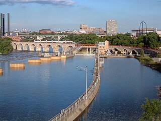
The Stone Arch Bridge is a former railroad bridge crossing the Mississippi River at Saint Anthony Falls in downtown Minneapolis, Minnesota. It is the only arched bridge made of stone on the entire Mississippi River. It is the second oldest bridge on the river next to Eads Bridge. The bridge was built to connect the railway system to the new Union Depot, which at that time was planned to be built between Hennepin Avenue and Nicollet Avenue. The bridge was completed in 1883, costing $650,000 at the time. 117 Portland Avenue is the general address of the historic complex.

The Anoka–Champlin Mississippi River Bridge, also known as the Ferry Street Bridge, is a 10-span open spandrel concrete deck arch bridge that spans the Mississippi River between Anoka and Champlin, Minnesota, United States. It was built in 1929 by the Minneapolis Bridge Company, replacing an 1884 bridge at the same site.

Minnesota State Highway 26 is a state highway in southeastern corner of the U.S. state of Minnesota. At 21 miles (34 km) in length, Highway 26 runs parallel to the Mississippi River and is a portion of the Great River Road. The route begins at the Iowa state line where it continues as Iowa Highway 26, and ends at an intersection with Minnesota State Highway 16 south of La Crescent.
Transportation in the U.S. State of Minnesota consists of a complex network of roadways, railways, waterways and airports. The transportation system is generally overseen by the Minnesota Department of Transportation, a cabinet-level agency of the state government. Additionally, regional governments such as the Metropolitan Council have authority over regional planning for the transportation system and local governments such as cities and counties oversee the local transportation network.

Iowa Highway 26 is a 11-mile-long (18 km) state highway that runs from south to north in Allamakee County, Iowa. It begins in Lansing at an intersection with Iowa Highway 9 at the Black Hawk Bridge and ends at the Minnesota border at New Albin. It continues into Minnesota as Minnesota State Highway 26. Iowa 26 was created in 1969 in a numbering swap with Iowa Highway 182. The designation was changed to match TH 26. The highway is the northernmost leg of the Great River Road in Iowa. Most of the highway is designated the Driftless Area Scenic Byway.

Fish Farm Mounds State Preserve is a 3-acre (12,000 m2) archaeological mound group containing Native American burials in the U.S. state of Iowa. It is located within the larger Fish Farms Mounds Wildlife area, a state owned hunting area a few miles south of New Albin, just inland from the Upper Mississippi River in Allamakee County.

Transportation in Omaha, Nebraska, includes most major modes, such as pedestrian, bicycle, automobile, bus, train and airplane. While early transportation consisted of ferries, stagecoaches, steamboats, street railroads, and railroads, the city's transportation systems have evolved to include the Interstate Highway System, parklike boulevards and a variety of bicycle and pedestrian trails. The historic head of several important emigrant trails and the First transcontinental railroad, its center as a national transportation hub earned Omaha the nickname "Gate City of the West" as early as the 1860s.

The Village of East Davenport, also known simply as The Village, is located along the Mississippi River on the southeast side of Davenport, Iowa, United States. It was listed as a historic district on the National Register of Historic Places in 1980 as the Davenport Village. At the time of its nomination it included 145 contributing properties, most of which were working-class housing.
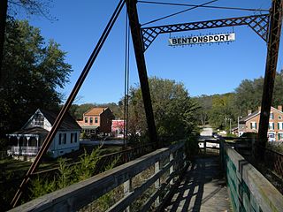
Bentonsport, a village on the Des Moines River near Keosauqua, in Van Buren County, Iowa, was recognized in 1972 for being very little changed since its historic heyday as a thriving steamboat port in the mid-1800s. A 35-acre (14 ha) historic district covering 16 original blocks in the historic center of the village was then approved for listing on the National Register of Historic Places. The district also included waterfront property and the village's historic wagon bridge across the river to the village of Vernon.

Joseph Reynolds was an American entrepreneur and founder of the Diamond Jo Line, a transportation company which operated steamboats on the upper Mississippi River. In his youth, while still living in upstate New York, he operated a butchery, a general store, a grain mill, and a tannery.

Cody Road Historic District is a nationally recognized historic district located in Le Claire, Iowa, United States. It includes 60 buildings along a nine-block stretch of U.S. Route 67, Cody Road, the primary street through the town. The district contains Le Claire's main commercial district on the south side of the district and residential area on the north. The district has been listed on the National Register of Historic Places since 1979.

Ada Village Hall is the former center for local government in Ada, Minnesota, United States. Completed in 1904, it was also an important public meeting hall and social facility through the 1970s. Architecturally, the building is an excellent example of the combined city hall and fire hall buildings that were constructed in Minnesota during the early 20th century. It was listed on the National Register of Historic Places for having local significance to politics/government and social history.

The West Liberty Commercial Historic District in West Liberty, Iowa, United States, is a historic district that was listed on the National Register of Historic Places in 2002. At that time, it included 41 contributing buildings, six other contributing structures, and eight non-contributing buildings.
The history of Winona, Minnesota as a settlement begins with the foundation in 1851 in what was then Minnesota Territory on the West side of the Mississippi River. The site was of the village of Keoxa of Dakota people. The name "Winona" (Wee-no-nah) was noted to be the name of a first-born daughter in the local Dakota language.

The Daniel Dayton House, also known as Ravine House, is a historic stagecoach inn in Harmony Township, Minnesota, United States. It was built in 1857 as an overnight stop on the Dubuque–St. Paul Stage Road, a frontier mail and stagecoach route through Iowa and Minnesota. The house was listed on the National Register of Historic Places in 1977 for its local significance in the themes of architecture, exploration/settlement, and transportation. It was nominated for being one of Minnesota's few surviving stagecoach inns, for its stone architecture, and for its association with the pioneer era of Harmony Township.

The Davenport Downtown Commercial Historic District is a nationally recognized historic district located in the central business district of Davenport, Iowa, United States. It was listed on the National Register of Historic Places in 2020. At the time of its nomination it consisted of 43 resources, which included 33 contributing buildings, one contributing structure, and nine non-contributing buildings. In addition, the district also contains 33 buildings that are individually listed on the National Register. This historic district is bordered by four other districts: the Crescent Warehouse Historic District and the Davenport Motor Row and Industrial Historic District on the east, the Hamburg Historic District to the northwest, and the West Third Street Historic District on the west.


