Jesus Backside Beach

Last updated

Deserted Beach (6395938771).jpg
View of the beach from Cape Fatucama
East Timor relief location map.jpg
Red pog.svg
LocationHera, Cristo Rei, East Timor
Nearest city Dili
Coordinates 8°31′19″S125°36′51″E / 8.522021°S 125.614039°E / -8.522021; 125.614039
Named for Cristo Rei of Dili

Jesus Backside Beach or Dolok Oan Beach (Portuguese : Praia dos Portugueses, Tetum : Dolok Oan) is a public beach located in the suco of Hera, a short distance north east of Dili, East Timor. The beach forms part of the south shore of Wetar Strait, immediately to the east of Cape Fatucama.

Contents

Etymology

The beach's "precise but utterly uncharming" [1] most commonly used English language name, Jesus Backside Beach, alludes to the colossal Cristo Rei of Dili statue located immediately to its west. As the statue faces in a westerly direction, it presents its rear or back side to the beach. [2]

In Portuguese, the beach is often referred to as Praia dos Portugueses (transl.Beach of the Portuguese), which is an allusion to its popularity with National Republican Guard (GNR) troops when they are stationed in East Timor. [3] In Tetum, and sometimes also in English [4] or Portuguese, [5] the beach is referred to as Dolok Oan, which is a combination of the Tetum words for wet ground (Dolok) and a child (Oan). [2]

Geography

Jesus Backside Beach is composed of white sand [2] [6] and is almost 1 km (0.62 mi) long. [2] It is situated immediately to the east of Cape Fatucama, which is at the north eastern end of the Bay of Dili, about 7 km (4.3 mi) from the centre of Dili, capital city of East Timor. [7] [8] [9]

The beach faces Wetar Strait, the body of water that separates the north eastern shore of Timor from the Indonesian island of Wetar to its north. [10] Its land side is surrounded by steep low hills overlaid with Eucalyptus alba savanna woodland, in which small stands of tropical dry forest are developing. [11] [12] The beach and woodland are both part of the Areia Branca no Dolok Oan Important Bird Area. [12]

At the peak of Cape Fatucama is the Cristo Rei of Dili statue, which is accessible from the car park at nearby Cristo Rei Beach, just inside the Bay of Dili on the other side of the Cape, via a 570-step concrete staircase. [2] [8] [9]

The beach is popular with both locals and tourists. [13] Pedestrian access is provided by a combination of the main staircase to Cristo Rei of Dili and a second concrete staircase descending from about one third of the way up the main staircase. [2] [9] There is also vehicle access, via a rough road that enters the area from the east. [11]

The waves at the beach are stronger than those at the more sheltered Cristo Rei Beach, and some parts of it are fringed by rocky reefs. [2] [4] Good snorkeling is available directly from the shore. [1] Despite the barriers to access, the beach is popular with local residents and tourists on Sundays and holidays, and occasionally also attracts people on company sponsored outings or taking diving lessons. [2] [5] [11]

Facilities

Other than the car park at Cristo Rei Beach, the staircases providing access for pedestrians, and the rough road that gives access to vehicles, the beach is an unspoiled coastline with no facilities. [5] [14] There are no shelters other than the trees, no toilets, no snack shops and no lifeguard station; nothing is available for rent, and there are no hawkers offering food or any other items. [11]

Visitors to the beach have been observed responding to its lack of facilities by bringing their own equipment, such as beach mats and even whole dining sets including tables and chairs. [2] Some of them also set up and use barbecue pits to cook their own food. [2] [5]

See also

Related Research Articles

<span class="mw-page-title-main">Dili</span> Capital and largest city of East Timor / Timor Leste

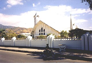
Dili is the capital and largest city of East Timor. It lies on the northern coast of the island of Timor, in a small area of flat land hemmed in by mountains. The climate is tropical, with distinct wet and dry seasons. The city has served as the economic hub and chief port of what is now East Timor since its designation as the capital of Portuguese Timor in 1769. It also serves as the capital of the Dili Municipality, which includes some rural subdivisions in addition to the urban ones which make up the city itself. Dili's growing population is relatively youthful, being mostly of working age. The local language is Tetum, however residents include many internal migrants from other areas of the country.

<span class="mw-page-title-main">Baucau Municipality</span> Municipality of East Timor

Baucau is a municipality, and was formerly a district, of East Timor, on the northern coast in the eastern part of the country. The capital is also called Baucau. The population of the municipality is 111,694 and it has an area of 1,506 km².

<span class="mw-page-title-main">União Nacional dos Escuteiros de Timor-Leste</span>

The União Nacional dos Escuteiros de Timor-Leste is the national Scouting organization of East Timor. It was founded on December 2, 2005 through the merger of the Corpo de Escuteiros Católicos em Timor-Leste and of Timor-Leste Scouting. The organization is a member of the Comunidade do Escutismo Lusófono. It became a member of the World Organization of the Scout Movement on 22 June 2017.

<span class="mw-page-title-main">Atauro</span> East Timorese island and municipality north of Dili

Atauro, also known as Kambing Island, is an island and municipality of East Timor. Atauro is a small oceanic island situated north of Dili, on the extinct Wetar segment of the volcanic Inner Banda Arc, between the Indonesian islands of Alor and Wetar. The nearest island is the Indonesian island of Liran, 13.0 km (8.1 mi) to the northeast. At the 2015 census, it had 9,274 inhabitants.

<span class="mw-page-title-main">Lautém Municipality</span> Municipality of East Timor

Lautém is one of the municipalities of East Timor, at the eastern end of the country. It has a population of 64,135 and an area of 1,813 km². Its capital is Lospalos, which lies 248 km east of the national capital, Dili.

<span class="mw-page-title-main">Manatuto Municipality</span> Municipality of East Timor

Manatuto is one of the municipalities of East Timor, located in the central part of the country. It has a population of 45,541 and an area of 1,783.3 km². The capital of the municipality is also named Manatuto. It is the least populated municipality of East Timor.

<span class="mw-page-title-main">Dili Municipality</span> Municipality of East Timor

Dili Municipality is one of the 14 municipalities, formerly districts, of Timor-Leste, and includes the national capital Dili. The municipality had a population of 277,279 as of 2015, most of whom live in the capital city.

<span class="mw-page-title-main">Ombai Strait</span> Strait in Southeast Asia

Ombai Strait is an international strait in Southeast Asia. It separates the Alor Archipelago from the islands of Wetar, Atauro, and Timor in the Lesser Sunda Islands. The strait is also the western portion of a pair of international straits, the other one being Wetar Strait; the two straits combine to link the Pacific Ocean with the Indian Ocean.

<span class="mw-page-title-main">Wetar Strait</span> Strait in Southeast Asia

Wetar Strait is an international strait in Southeast Asia. It separates the island of Wetar from the eastern part of the island of Timor. The strait is also the eastern portion of a pair of international straits, the other one being Ombai Strait; the two straits combine to link the Indian Ocean with the Pacific Ocean.

<i>Cristo Rei of Dili</i> Statue of Jesus Christ in Dili, East Timor

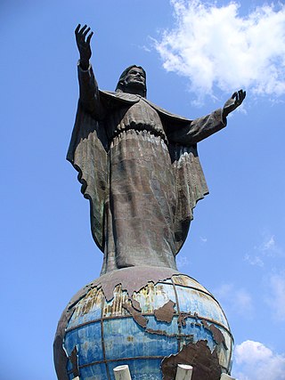
The Cristo Rei of Dili statue is a 27.0-metre-high (88.6 ft) colossal statue of Jesus Christ situated atop a globe at Cape Fatucama in Dili, East Timor. It is one of East Timor's main tourist attractions.

<span class="mw-page-title-main">Cristo Rei Administrative Post</span> Administrative post in Dili Municipality, East Timor

Cristo Rei, officially Cristo Rei Administrative Post, is an administrative post in Dili municipality, East Timor. Its seat or administrative centre is Becora, and its population at the 2010 census was 54,936.

<span class="mw-page-title-main">Tasitolu</span> Protected area in East Timor

Tasitolu is a protected area on the coast of East Timor, 8 kilometres (5.0 mi) west of the capital Dili. The Tasitolu wetlands include three saline lakes, an esplanade, and a beach; it has been designated a Wetland of National Significance. Tasitolu Peace Park was designated in 2002 because of its cultural and historical importance. The Tasitolu Important Bird Area accommodates several near-threatened species. A 2004 reforestation project, which included community member participation, was funded by the national government. Subsequent to the 2006 East Timorese crisis, several hundred people sought refuge at Tasitolu's tent camp, established by the United Nations High Commissioner for Refugees. INTERFET, an Australian-led international military Peace Keeping Force governed by the United Nations, has established a base at Tasitolu.

<span class="mw-page-title-main">Areia Branca no Dolok Oan</span>

Areia Branca no Dolok Oan is a 2,916 ha Important Bird Area (IBA) in East Timor, a country occupying the eastern end of the island of Timor at the eastern end of the Lesser Sunda Islands group of Wallacea.

<span class="mw-page-title-main">Bay of Dili</span> Bay in East Timor

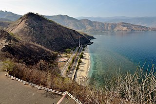
The Bay of Dili is a bay on the north coast of East Timor adjacent to Dili, its capital city. The bay forms part of Ombai Strait, which separates the Alor Archipelago from the islands of Wetar, Atauro, and Timor in the Lesser Sunda Islands.

<span class="mw-page-title-main">Cristo Rei Beach</span> Beach in the Bay of Dili, East Timor

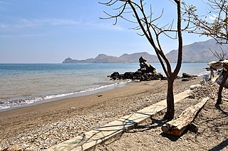
Cristo Rei Beach is a public beach facing the Bay of Dili in the suco of Metiaut, East Timor.

<span class="mw-page-title-main">Areia Branca Beach</span> Beach in the Bay of Dili, East Timor

Areia Branca Beach is a public beach on the north eastern shore of the Bay of Dili, in the suco of Metiaut, East Timor. It is very popular with both local residents and tourists.

<span class="mw-page-title-main">Cape Fatucama</span> Cape or large headland near Dili, East Timor

Cape Fatucama is a cape or large headland a short distance north east of Dili, on the north coast of East Timor. It is best known as the site of the Cristo Rei of Dili, a colossal statue of Jesus Christ.

<span class="mw-page-title-main">One Dollar Beach</span> Beach near Dili, East Timor

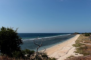
One Dollar Beach or Dollar Beach is a public beach on the north coast of East Timor, east north east of Dili, the capital city. It is long, white, sandy and clean, and also frequently deserted, yet popular with beach users at other times.

<span class="mw-page-title-main">Valu Beach</span> Beach in East Timor

Valu Beach is a public beach at the easternmost tip of mainland East Timor, and the gateway to Jaco Island to its east.

References

  1. 1 2 "East Timor travel guide". globespots.com. Retrieved 25 April 2022.
  2. 1 2 3 4 5 6 7 8 9 10 "Lakad Pilipinas: EAST TIMOR | The Beaches of Dili". Lakad Pilipinas. Retrieved 19 March 2022.
  3. Pereira-Müller, M.Margarida (2013). "Singapura e Timor: Suai-Maliana-Batugadé-Maubara-Dili". Cadernos de Viagem (in Portuguese) (91): 23. Retrieved 19 March 2022.
  4. 1 2 Raynor, Sophie (13 January 2020). "The Coco Travel Guide to Dili: A weekend of nature, culture, history and food in the seaside Timor-Leste capital". Coconuts. Coconuts Media . Retrieved 19 March 2022.
  5. 1 2 3 4 Gosaves, Lucivânia (7 May 2020). "10 pontos turísticos do Timor-Leste, na Ásia" [10 tourist attractions in East Timor, Asia]. Quero Viajar Mais (in Portuguese). Retrieved 19 March 2022.
  6. Yunus, Ahmad (24 March 2008). "Di Balik Cristo Rei Timor Leste" [Behind Cristo Rei Timor Leste]. Aceh Feature (in Indonesian). Archived from the original on 1 December 2010. Retrieved 18 March 2022.
  7. "Cristo Rei in Timor-Leste". The Elevated Moments. 19 August 2019. Retrieved 18 March 2022.
  8. 1 2 Gregory, David. "Hike to Cristo Rei of Dili". www.theoutbound.com. Retrieved 18 March 2022.
  9. 1 2 3 "Lakad Pilipinas: EAST TIMOR | Climbing the Cristo Rei of Dili". Lakad Pilipinas. Retrieved 18 March 2022.
  10. Leifer, Michael (1978). Malacca, Singapore, and Indonesia. International Straits of the World, Volume 2. Alphen aan den Rijn: Sijthoff & Noordhoff. pp. 83–84. ISBN   9028607781.
  11. 1 2 3 4 Tan, Luna (7 September 2013). "Piece of Paradise at Jesus Backside Beach, Dili, East Timor". Life to Reset. Retrieved 19 March 2022.
  12. 1 2 BirdLife International (2022). "Important Bird Areas factsheet: Areia Branca no Dolok Oan". BirdLife International . Retrieved 19 March 2022.
  13. Bhatia, Aunindita (29 May 2022). "10 Facts About The Lesser-Known Timor-Leste". TheTravel. Retrieved 5 July 2022.
  14. Tan, Luna (27 July 2013). "Weekend with Jesus at the Beach, Cristo Rei, Dili, East Timor". Life to Reset. Retrieved 21 April 2022.

Commons-logo.svg Media related to Dolok Oan Beach at Wikimedia Commons