
Lod, also known as Lydda, is a city 15 km southeast of Tel Aviv and 40 km (25 mi) northwest of Jerusalem in the Central District of Israel. It is situated between the lower Shephelah on the east and the coastal plain on the west. The city had a population of 85,351 in 2019.

Ad Halom is a site at the eastern entrance to the city of Ashdod, Israel, where three bridges cross the Lakhish River.

Bayt Nabala or Beit Nabala was a Palestinian Arab village in the Ramle Subdistrict in Palestine that was destroyed during the 1948 Arab–Israeli War. The village was in the territory allotted to the Arab state under the 1947 UN Partition Plan, which was rejected by Arab leaders and never implemented. Its population in 1945, before the war, was 2,310.

The Church of Saint George in the city of Lod is a Greek Orthodox church containing a sarcophagus venerated as the tomb of the fourth-century Christian martyr Saint George.

Yazur was a Palestinian Arab town located 6 kilometers (3.7 mi) east of Jaffa. Mentioned in 7th century BCE Assyrian texts, the village was a site of contestation between Muslims and Crusaders in the 12th-13th centuries.

Gesher Bnot Ya'akov is a bridge that spans the last natural ford of the Jordan River at the southern end of the Hula Basin between the Korazim Plateau and the Golan Heights. It has been a crossing point for thousands of years.
Farkha is a Palestinian village located in the Salfit Governorate in the northern West Bank, 30 kilometers south of Nablus. According to the Palestinian Central Bureau of Statistics, it had a population of 1,650 in 2017.

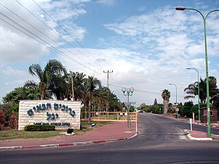
Ginaton is a moshav in central Israel. Located near Ben Shemen, it falls under the jurisdiction of Hevel Modi'in Regional Council. In 2022 it had a population of 867.
Yagel is a religious moshav in the Central District of Israel. Located near Lod and Ben Gurion International Airport, it falls under the jurisdiction of Sdot Dan Regional Council. In 2022 it had a population of 905.

Kharbatha Bani Harith is a Palestinian town in the central West Bank, located 15 kilometers west of Ramallah in the Ramallah and al-Bireh Governorate. The name of the town is probably a corruption of Khirbat Bani Harith. According to the Palestinian Central Bureau of Statistics, the town had a population of 3,471 in 2017. It has a total land area of 7,120 dunams.

Al-Safiriyya was a Palestinian Arab village in the Jaffa Subdistrict. It was depopulated during Operation Hametz in the 1948 Palestine War on May 20, 1948. It was located 11 km east of Jaffa, 1.5 km west of Ben Gurion Airport.

Bir Ma'in was a Palestinian Arab village in the Ramle Subdistrict. It was depopulated during the 1948 Arab-Israeli War on July 15, 1948 during the second phase of Operation Danny by the First and Second Battalions of the Yiftach Brigade. It was located 14 km east of Ramla. The village was defended by the Jordanian Army.
Khulda, also Khuldeh, was a Palestinian Arab village located 12 kilometers (7.5 mi) south of Ramla in the Mandatory Palestine. Known as Huldre to the Crusaders, it is also mentioned in documents dating to the periods of Mamluk, Ottoman, and Mandatory rule over Palestine. During the 1948 war, the village was depopulated as part of Operation Nachshon and was subsequently destroyed. The Israeli kibbutz of Mishmar David was established that same year on land belonging to the village.

The mausoleum of Abu Hurayra, or Rabban Gamaliel's Tomb, is a maqam turned synagogue in HaSanhedrin Park in Yavne, Israel, formerly belonging to the depopulated Palestinian village of Yibna. It has been described as "one of the finest domed mausoleums in Palestine."

The Yibna Bridge or Nahr Rubin Bridge is a Mamluk arch bridge near Yibna, which crosses the river Nahal Sorek. It was previously used by Route 410 to Rehovot, and was known as the Jumping Bridge due to a bump in the middle of the bridge which caused cars to jump if speeding. It is now a part of a recreation ground, next to a new bridge carrying the Route 410.

Jisr el-Majami or Jisr al-Mujamieh is an ancient stone bridge, possibly of Roman origin, over the Jordan River on the border between Israel and Jordan. The name is derived from the bridge's location 200 m (660 ft) south of the confluence of the Yarmouk and Jordan rivers.
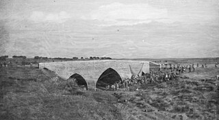
Jisr Isdud or Isdud Bridge, also known as the Ad Halom Bridge, was a 13th century Mamluk bridge built over the Lakhish River. It is located approximately 1.5 km north of the Ad Halom junction. The bridge is similar in style and history to the nearby Jisr Jindas and Yibna Bridge.

The Great Omari Mosque of Lod, also known as al-Omari Mosque or the Great Mosque of Lod, is a mosque in the city of Lod (Lydd), in Israel, which is located adjacent to the 19th-century Greek Orthodox Church of Saint George, allegedly erected over the tomb of the fourth-century martyr George of Lydda, who is frequently associated with the Muslim holy figure Al-Khadr.
Jindas is an archaeological site in modern-day Israel, 2 kilometers east of the city of Lod in Israel's Central District.
Subtara is an archaeological site in the Lod Valley, near the modern Israeli settlement of Yagel in Israel's Central District.


 Baibars' lion on the Bridge of Jindas
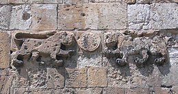 Baibars' lions on Lions' Gate, Jerusalem
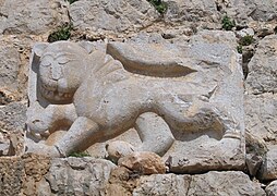 Baibars' lion from Qal'at al-Subeiba, at the foot of Mount Hermon


